close
-
Layers w
- Weather Layers
- Pro
- Pro
- Pro
- Pro
- Pro
- Pro
- More Layers
- Pro
- Pro
- Pro
- Pro
-
Upgrade to

3D
Trail Conditions
- Unknown
- Snow Groomed
- Snow Packed
- Snow Covered
- Snow Cover Partial
- Freeze/thaw Cycle
- Icy
- Prevalent Mud
- Wet
- Variable
- Ideal
- Dry
- Very Dry
Trail Flow (Ridden Direction)
Trailforks scans users ridelogs to determine the most popular direction each trail is ridden. A good flowing trail network will have most trails flowing in a single direction according to their intension.
The colour categories are based on what percentage of riders are riding a trail in its intended direction.
The colour categories are based on what percentage of riders are riding a trail in its intended direction.
- > 96%
- > 90%
- > 80%
- > 70%
- > 50%
- < 50%
- bi-directional trail
- no data
Trail Last Ridden
Trailforks scans ridelogs to determine the last time a trail was ridden.
- < 2 days
- < 1 week
- < 2 weeks
- < 1 month
- < 6 months
- > 6 months
Trail Ridden Direction
The intended direction a trail should be ridden.
- Downhill Only
- Downhill Primary
- Both Directions
- Uphill Primary
- Uphill Only
- One Direction
Contribute Details
Colors indicate trail is missing specified detail.
- Description
- Photos
- Description & Photos
- Videos
Trail Popularity ?
Trailforks scans ridelogs to determine which trails are ridden the most in the last 9 months.
Trails are compared with nearby trails in the same city region with a possible 25 colour shades.
Think of this as a heatmap, more rides = more kinetic energy = warmer colors.
- most popular
- popular
- less popular
- not popular
ATV/ORV/OHV Filter
Max Vehicle Width
inches
US Cell Coverage
Legend

Radar Time
Activity Recordings
Trailforks uses anonymized public activity data.
?
Activity Recordings
Trailforks uses anonymized public activity data.
?
Personal Heatmap
▶
Activity Types
all
/
none
▶
Options
2
Date range
month
–
Winter Trails
Warning
A routing network for winter maps does not exist. Selecting trails using the winter trails layer has been disabled.
Missing Trails
Most Popular
Least Popular
Trails are colored based on popularity. The more popular a trail is, the more red. Less popular trails trend towards green.
Jump Magnitude Heatmap
Heatmap of where riders jump on trails. Zoom in to see individual jumps, click circles to view jump details.
BC Backroad Status
![map legend]()
Service Road Atlas is a free to use, community-driven service for viewing and creating reports on the numerous back-country service roads around B.C. and Alberta.

Slope Aspect
Direction the slope faces
Trails Deemphasized
Trails are shown in grey.
Only show trails with no bike usage.
Suggested Layers
Based on selected activity type
Save the current map location and zoom level as your default home location whenever this page is loaded.
Save
No description for Sula has been added yet!
Login or register to submit one.
Links
Activities Click to view
- Mountain Bike
30 trails
- Gravel Bike
0 trails
- Adaptive Bike
0 trails
- Horse
28 trails
- Hike
31 trails
- Trail Running
31 trails
- Dirtbike/Moto
10 trails
Stats
- Avg Trail Rating
- Trails (view details)
- 31
- Trails Mountain Bike
- 30
- Trails Horse
- 28
- Trails Hike
- 31
- Trails Trail Running
- 31
- Trails Dirtbike/Moto
- 10
- Trails ATV/ORV/OHV
- 1
- Total Distance
- 135 miles
- Total Descent
- 31,757 ft
- Total Vertical
- 4,059 ft
- Highest Trailhead
- 8,394 ft
- Reports
- 235
- Photos
- 54
- Ridden Counter
- 904
Sub Regions
-
Warm Springs / Lost Trail Pass
- 8
- 12
- 3
Popular Sula Mountain Biking Trails
• 100 ★ 4.3 • 15 miles • 1,824 ft • 137 •
Warm Springs Ridge is one of the best trails in the area. Mtn Bike Associations from Hamilton-MT and Salmon-ID work to keep it in good shape, but expect deadfall from the forest fire burn of 2000. The south section from to Porcupine...
• 100 ★ 4.3 • 5 miles • 526 ft • 94 •
A great trail. Short rocky areas breakup the long sections of singletrack. Expect a couple stream crossings. Vegetation can be thick to the south end of the trail and junction w/ .
• 70 ★ 4.8 • 4 miles • 271 ft • 71 •
A great descent, nothing too technical and plenty of switchback practice on the lower portion. Climbing is tough but enjoyable earning great views.
• 75 ★ 4.8 • 3 miles • 1,721 ft • 68 •
29 switchbacks! Very ridable climbing and super fun descending. Video shows climbing Warm Springs Ridge then the Porcupine Creek Trail descent w/ 29 switchbacks.
• 80 ★ 4.2 • 2 miles • 407 ft • 65 •
Good singletrack paralleling Porcupine Creek. Some loose, gravel sections challenge the skills. Otherwise excellent riding. Twogood Cabin sits along this section of trail, and can be rented from the USFS via recreation.gov.
• 95 ★ 4.0 • 2 miles • 209 ft • 65 •
Good trail segment to ride to view Overwich Falls or access Capri Lake, or out Warm Springs Creek.
• 90 ★ 4.3 • 3 miles • 131 ft • 56 •
Good out and back or loop ride using other trails.
• 80 ★ 4.2 • 3 miles • 378 ft • 54 •
This trail segment can be used to do a great shuttle ride from Lost Trail to Hwy 93. It has the most technical riding of the Warm Springs Area Trails with chunky sections, rocks and tight switchbacks.
Sula Mountain Bike Routes
28 miles • 4,471 ft • 7 •
A big, scenic loop in the Warm Springs area. You'll feel truly out there at Overwhich Falls and Shields Creek.
20 miles • 4,834 ft • 0 • Loop •
Another sweet ride in the Warm Springs area, and of all the rides this one just might have the most...
• 16 miles • 2,546 ft • 5 •
• 8 miles • 2,249 ft • 0 •
• 18 miles • 1,443 ft • 1 •
• 21 miles • 2,911 ft • 2 •
Photos of Sula Mountain Bike
Videos of Sula Mountain Bike
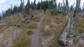
trail: Warm Springs Ridge
1403 |
Sep 26, 2015 , Sula
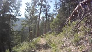
trail: Porcupine Creek
1077 |
Oct 12, 2014 , Sula
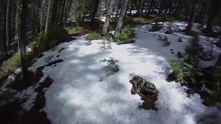
trail: Fire Creek
975 |
Oct 3, 2014 , Sula
Recent Trail Reports
| status | trail | date | condition | info | user |
|---|---|---|---|---|---|
| Overwhich Falls | Jun 14, 2026 @ 9:45pm (America/Denver) 1 hours | Unknown | jkernmt | ||
| Shields Creek | Jun 14, 2026 @ 9:44pm (America/Denver) 1 hours | Unknown | jkernmt | ||
| Colter Creek | Jun 14, 2026 @ 9:42pm (America/Denver) 1 hours | Unknown | jkernmt | ||
| Warm Springs Ridge | Jun 13, 2026 @ 12:20pm (America/Boise) 1 day | Dry | Jjsze13 | ||
| Porcupine Creek | Aug 15, 2025 @ 5:26am Aug 15, 2025 | Unknown | oldermountain | ||
| Piquett Creek | Aug 9, 2025 @ 8:25am Aug 9, 2025 | Unknown | jkernmt | ||
| Tolan Ridge | Jul 31, 2025 @ 2:38pm Jul 31, 2025 | Ideal | jkernmt | ||
| Hughes Point | Jul 27, 2025 @ 7:04pm Jul 27, 2025 | Ideal | chuktA TRAILFORKS | ||
| Reimel Creek Trail | Jul 21, 2025 @ 9:36am Jul 21, 2025 | Variable | jkernmt | ||
| Warm Springs Creek (South) | Jun 21, 2025 @ 10:39am Jun 21, 2025 | Dry | jkernmt |
Activity Feed
| username | action | type | title | date |
|---|---|---|---|---|
| jkernmt | add | report | activity #97021388 and 2 more | Jun 14, 2026 @ 8:42pm 1 hours |
| Jjsze13 | add | report | activity #97015579 | Jun 14, 2026 @ 5:38pm 4 hours |
| Jjsze13 | wishlist | trail | activity #96738724 | Jun 11, 2026 @ 8:13am Jun 11, 2026 |
| AaronDzFuKF | wishlist | trail | activity #96542450 | Jun 8, 2026 @ 8:48am Jun 8, 2026 |
| RodneyMTB | wishlist | route | activity #96168239 | Jun 3, 2026 @ 11:06am Jun 3, 2026 |
Recent Comments
| username | type | title | comment | date |
|---|---|---|---|---|
| trail | Supa fast. Totes worth it. | Aug 24, 2025 @ 9:32pm Aug 24, 2025 | ||
| trail | Up and over climb, you may lose the trail... | Aug 9, 2024 @ 9:36pm Aug 9, 2024 | ||
| trail | Super technical fun back country trail when... | Aug 9, 2024 @ 9:32pm Aug 9, 2024 | ||
| trail | Nice trail, fast, good scenery. i would say... | Aug 9, 2024 @ 6:36pm Aug 9, 2024 | ||
| report | Awesome! Thank you! | Jun 22, 2024 @ 8:27pm Jun 22, 2024 |
Local Badges
-

Epic Ride Climb 2k9 awarded -

Climbing 10k Badge1 awarded -

Climbing 100k Badge0 awarded -

Epic Ride Descent 2k15 awarded -

Descent 10k Badge3 awarded -

Descent 100k Badge0 awarded
Activity Type Stats
| activitytype | trails | distance | descent | descent distance | total vertical | rating | global rank | state rank | photos | reports | routes | ridelogs |
|---|---|---|---|---|---|---|---|---|---|---|---|---|
| Mountain Bike | 30 | 133 miles | 31,759 ft | 64 miles | 4,058 ft | #1,974 | #719 | 54 | 235 | 2 | 531 | |
| Horse | 28 | 115 miles | 27,356 ft | 56 miles | 4,029 ft | #502 | #505 | 212 | 1 | |||
| Hike | 31 | 135 miles | 31,759 ft | 64 miles | 4,058 ft | #2,111 | #882 | 235 | 1 | 137 | ||
| Trail Running | 31 | 135 miles | 31,759 ft | 64 miles | 4,058 ft | #1,654 | #562 | 235 | 1 | 13 | ||
| Dirtbike/Moto | 10 | 40 miles | 11,093 ft | 21 miles | 3,921 ft | #777 | #276 | 166 | 9 | |||
| ATV/ORV/OHV | 1 | 4 miles | 3 ft | 545 ft | 1,135 ft | 130 | 1 |
Frequently Asked Questions About Sula
▼
What are the best places to ride in Sula?
Sula has 1 areas to explore for mountain biking. The top rated areas are:
▼
What are the highest rated mountain biking trails in Sula?
The highest rated mountain biking trails in Sula are:
- Hughes Point (Colter Creek) (4.3/5)
- Porcupine Creek (4.3/5)
- Fire Creek (4.3/5)
- Piquett Ridge (4.2/5)
- Warm Springs Ridge (4.2/5)
▼
What is the best time of the year to ride in Sula?
Based on ride log data, the most popular months to ride in Sula are:
- August (27 activities)
- July (17 activities)
- June (12 activities)
▼
Where can I park to ride in Sula?
There are 8 parking locations listed in Sula. The most popular parking spots are: View all parking and trailhead locations on the map to plan your visit.
Activities
Trails
- By chuktA
 TRAILFORKS NFTA & contributors
 - Admins: BBC
- #5208 - 3,560 views
- sula activity log | embed map of Sula mountain bike trails | sula mountain biking points of interest
Downloading of trail gps tracks in kml & gpx formats is enabled for Sula.
You must login to download files.