close
-
Layers w
- Weather Layers
- Pro
- Pro
- Pro
- Pro
- Pro
- Pro
- More Layers
- Pro
- Pro
- Pro
- Pro
-
Upgrade to

3D
Trail Conditions
- Unknown
- Snow Groomed
- Snow Packed
- Snow Covered
- Snow Cover Partial
- Freeze/thaw Cycle
- Icy
- Prevalent Mud
- Wet
- Variable
- Ideal
- Dry
- Very Dry
Trail Flow (Ridden Direction)
Trailforks scans users ridelogs to determine the most popular direction each trail is ridden. A good flowing trail network will have most trails flowing in a single direction according to their intension.
The colour categories are based on what percentage of riders are riding a trail in its intended direction.
The colour categories are based on what percentage of riders are riding a trail in its intended direction.
- > 96%
- > 90%
- > 80%
- > 70%
- > 50%
- < 50%
- bi-directional trail
- no data
Trail Last Ridden
Trailforks scans ridelogs to determine the last time a trail was ridden.
- < 2 days
- < 1 week
- < 2 weeks
- < 1 month
- < 6 months
- > 6 months
Trail Ridden Direction
The intended direction a trail should be ridden.
- Downhill Only
- Downhill Primary
- Both Directions
- Uphill Primary
- Uphill Only
- One Direction
Contribute Details
Colors indicate trail is missing specified detail.
- Description
- Photos
- Description & Photos
- Videos
Trail Popularity ?
Trailforks scans ridelogs to determine which trails are ridden the most in the last 9 months.
Trails are compared with nearby trails in the same city region with a possible 25 colour shades.
Think of this as a heatmap, more rides = more kinetic energy = warmer colors.
- most popular
- popular
- less popular
- not popular
ATV/ORV/OHV Filter
Max Vehicle Width
inches
US Cell Coverage
Legend

Radar Time
Activity Recordings
Trailforks uses anonymized public activity data.
?
Activity Recordings
Trailforks uses anonymized public activity data.
?
Personal Heatmap
▶
Activity Types
all
/
none
▶
Options
2
Date range
month
–
Winter Trails
Warning
A routing network for winter maps does not exist. Selecting trails using the winter trails layer has been disabled.
Missing Trails
Most Popular
Least Popular
Trails are colored based on popularity. The more popular a trail is, the more red. Less popular trails trend towards green.
Jump Magnitude Heatmap
Heatmap of where riders jump on trails. Zoom in to see individual jumps, click circles to view jump details.
BC Backroad Status
![map legend]()
Service Road Atlas is a free to use, community-driven service for viewing and creating reports on the numerous back-country service roads around B.C. and Alberta.

Slope Aspect
Direction the slope faces
Trails Deemphasized
Trails are shown in grey.
Only show trails with no bike usage.
Suggested Layers
Based on selected activity type
Save the current map location and zoom level as your default home location whenever this page is loaded.
SaveTurkey Point offers over 85 kms of sandy and hardpacked cross country super fast singletrack trails managed by the Turkey Point Mountain Bike Club (TPMBC) in association with several different landowners. This trail network is a hidden jewel and rideable most of the year.
Activities Click to view
- Mountain Bike
131 trails
- E-Bike
23 trails
- Gravel Bike
1 trails
- Adaptive Bike
2 trails
- Winter Fat Bike
2 trails
- Hike
130 trails
- Trail Running
130 trails
- ATV/ORV/OHV
8 trails
- Snowshoe
46 trails
- Nordic Ski
14 trails
Region Details
- 28
- 8
- 47
- 27
- 18
- 3
Region Status
Open as of Jun 27, 2026Stats
- Avg Trail Rating
- Trails (view details)
- 131
- Trails Mountain Bike
- 131
- Trails E-Bike
- 23
- Trails Gravel Bike
- 1
- Trails Adaptive Bike
- 2
- Trails Winter Fat Bike
- 2
- Trails Hike
- 130
- Trails Trail Running
- 130
- Trails ATV/ORV/OHV
- 8
- Trails Snowshoe
- 46
- Trails Nordic Ski
- 14
- Total Distance
- 70 miles
- Total Descent
- 2,141 ft
- Total Vertical
- 126 ft
- Highest Trailhead
- 728 ft
- Reports
- 4,388
- Photos
- 268
- Ridden Counter
- 55,644
Sub Regions
-
St. Williams Conservation Reserve - Turkey Point Tract
- 4
- 1
-
Turkey Point Provincial Park
- 9
Popular Turkey Point Mountain Biking Trails
• 100 ★ 4.4 • 3,320 ft • 10 ft • 1,386 •
Tight turns on this track. Tough root section, and some fun features... Enjoy.
• 95 ★ 4.6 • 4,121 ft • 3 ft • 1,199 •
Highly rated popular black diamond difficulty singletrack. This mountain bike primary trail can be used downhill primary. On average it takes 8 minutes to complete this trail.
• 95 ★ 3.9 • 3,294 ft • 63 ft • 1,130 •
Popular black diamond difficulty singletrack. This mountain bike primary trail can be used both directions and has a moderate overall physical rating. On average it takes 6 minutes to complete this trail.
• 90 ★ 2.0 • 2,513 ft • 51 ft • 1,119 •
Popular green difficulty singletrack. This mountain bike primary trail can be used downhill primary. On average it takes 3 minutes to complete this trail.
• 100 ★ 4.3 • 4,157 ft • 3 ft • 1,113 •
This is a great trail to start on. Go slow and this trail is a green, speed up and make this trail as fun or hard as you like.
• 100 ★ 4.3 • 1 mile • 8 ft • 1,097 •
Highly rated popular blue difficulty singletrack. This mountain bike primary trail can be used both directions and has a moderate overall physical rating with a 8 ft blue climb. On average it takes 9 minutes to complete this trail.
Turkey Point Mountain Bike Routes
★ 5.0 • 16 miles • 596 ft • 16 • Loop •
A great introductory ride to the Turkey Point area. Experience the Carolinian Rainforest as well as the...
★ 5.0 • 20 miles • 750 ft • 20 • Loop •
Activate “Beast Mode” for this tour of all the advanced trails on the East Side of Turkey Point...
★ 5.0 • 20 miles • 630 ft • 24 • Loop •
Turkey Point Northern Tier Route. Ride all the trails north of fish hatchery in one large interweaving...
40 miles • 1,523 ft • 56 • Out & Back •
Route to cover the majority of Turkey Point in a fun loop.
15 miles • 865 ft • 18 • Loop •
Buckle up for the Nor’Easter! A continuous loop off all the trails in the North East quadrant of Turkey...
7 miles • 180 ft • 8 • Out & Back •
Easy route of mostly Beginner and Intermediate trails with a few easy “Advanced” trails tossed in. A...
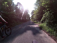
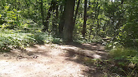
Photos of Turkey Point Mountain Bike
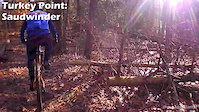
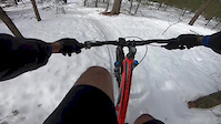
Videos of Turkey Point Mountain Bike
trail: Saudwinder
0:12 |
53 |
Aug 1, 2021
trail: Saudwinder
3:28 |
98 |
Dec 31, 2019
trail: Big Mike
0:09 |
217 |
Jul 25, 2019
trail: The Burn
0:47 |
136 |
Mar 10, 2018

3:01 |
495 |
May 9, 2014

0:43 |
1756 |
Jun 4, 2013

2:39 |
71556 |
May 20, 2013

0:40 |
1364 |
Apr 26, 2013
Recent Trail Reports
| status | trail | date | condition | info | user |
|---|---|---|---|---|---|
| Earshot | Jun 27, 2026 @ 2:28pm (America/Toronto) Jun 27, 2026 | Ideal | RyderRowsell | ||
| Roughshod | Jun 24, 2026 @ 9:34am (America/Toronto) Jun 24, 2026 | Ideal | AstroDover | ||
| Pail Trail | Jun 24, 2026 @ 9:34am (America/Toronto) Jun 24, 2026 | Ideal | AstroDover | ||
| Dizzy Lizzy | Jun 24, 2026 @ 9:34am (America/Toronto) Jun 24, 2026 | Ideal | AstroDover | ||
| Fin & Feather - Mole Road Connector | Jun 24, 2026 @ 9:34am (America/Toronto) Jun 24, 2026 | Ideal | AstroDover | ||
| Saudwinder | Jun 24, 2026 @ 9:34am (America/Toronto) Jun 24, 2026 | Ideal | AstroDover | ||
| The Burn | Jun 24, 2026 @ 9:34am (America/Toronto) Jun 24, 2026 | Ideal | AstroDover | ||
| Rainbow Ridge - Green | Jun 24, 2026 @ 9:34am (America/Toronto) Jun 24, 2026 | Ideal | AstroDover | ||
| Hot Flash | Jun 24, 2026 @ 9:34am (America/Toronto) Jun 24, 2026 | Ideal | AstroDover | ||
| Toxicity | Jun 24, 2026 @ 9:34am (America/Toronto) Jun 24, 2026 | Ideal | AstroDover |
Activity Feed
| username | action | type | title | date |
|---|---|---|---|---|
| fishpond | update | trail | activity #99071672 | Jul 12, 2026 @ 6:15pm 16 hours |
| fishpond | add | trail | activity #99068947 and 1 more | Jul 12, 2026 @ 5:14pm 17 hours |
| rich212 | wishlist | route | activity #98202242 | Jul 1, 2026 @ 8:25am Jul 1, 2026 |
| rich212 | wishlist | trail | activity #98194619 | Jul 1, 2026 @ 6:11am Jul 1, 2026 |
| RichD76 | wishlist | region | activity #98116253 | Jun 30, 2026 @ 2:32am Jun 30, 2026 |
Recent Comments
| username | type | title | comment | date |
|---|---|---|---|---|
| report | Mint. Running fast | Mar 21, 2026 @ 7:30pm Mar 21, 2026 | ||
| trail | Awesome trail cool features | Aug 4, 2025 @ 2:22am Aug 4, 2025 | ||
| trail | Very fun, flowy trail | Jul 28, 2025 @ 11:31am Jul 28, 2025 | ||
| trail | This trail feels like a bit of a hidden gem.... | Jul 28, 2025 @ 11:27am Jul 28, 2025 | ||
| report | Not Picetum but Pettifogger direction where it... | Sep 13, 2024 @ 8:06pm Sep 13, 2024 |
Local Badges
-

10 Green Trails635 awarded -

10 Blue Trails626 awarded -

10 Black Trails505 awarded -

Epic Ride Climb 2k1 awarded -

Climbing 10k Badge34 awarded -

Climbing 100k Badge0 awarded
Activity Type Stats
| activitytype | trails | distance | descent | descent distance | total vertical | rating | global rank | state rank | photos | reports | routes | ridelogs |
|---|---|---|---|---|---|---|---|---|---|---|---|---|
| Mountain Bike | 131 | 70 miles | 2,142 ft | 14 miles | 125 ft | #356 | #15 | 263 | 4,351 | 11 | 21,407 | |
| E-Bike | 23 | 7 miles | 56 ft | 5,187 ft | 66 ft | #3,971 | #73 | 3,711 | 566 | |||
| Gravel Bike | 1 | #169 | #21 | 10 | 53 | |||||||
| Adaptive Bike | 2 | #169 | #33 | 2 | ||||||||
| Winter Fat Bike | 2 | #169 | #29 | 12 | 1 | 11 | ||||||
| Hike | 130 | 68 miles | 2,047 ft | 14 miles | 125 ft | #854 | #22 | 5 | 4,321 | 526 | ||
| Trail Running | 130 | 68 miles | 2,047 ft | 14 miles | 125 ft | #582 | #11 | 4,320 | 344 | |||
| ATV/ORV/OHV | 8 | 4 miles | 13 ft | 1,745 ft | 16 ft | #500 | #8 | 1,233 | 1 | |||
| Snowshoe | 46 | 20 miles | 331 ft | 3 miles | 118 ft | #438 | #44 | 46 | 46 | |||
| Nordic Ski | 14 | 6 miles | 16 ft | 3,583 ft | 20 ft | #675 | #45 | 23 | 40 |
Frequently Asked Questions About Turkey Point
▼
What are the best places to ride in Turkey Point?
Turkey Point has 2 areas to explore for mountain biking. The top rated areas are:
▼
What are the highest rated mountain biking trails in Turkey Point?
The highest rated mountain biking trails in Turkey Point are:
- High Mile (4.5/5)
- The Stroller (4.5/5)
- Summit (4.5/5)
- Planet of the Apes Trail (4.4/5)
- Dizzy Lizzy (4.4/5)
▼
What is the best time of the year to ride in Turkey Point?
Based on ride log data, the most popular months to ride in Turkey Point are:
- July (522 activities)
- August (433 activities)
- June (422 activities)
▼
Where can I park to ride in Turkey Point?
There are 6 parking locations listed in Turkey Point. The most popular parking spots are: View all parking and trailhead locations on the map to plan your visit.
Activities
Trails
- By grump444
 & contributors
 - Admins: TPMBC
- #4511 - 53,122 views
- turkey point activity log | embed map of Turkey Point mountain bike trails | turkey point mountain biking points of interest
Downloading of trail gps tracks in kml & gpx formats is enabled for Turkey Point.
You must login to download files.