
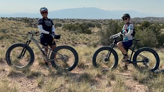
All singletrack Loop. Some of Cabazon Trail is getting overgrown so keep an eye on your map. Needs to be ridden more to keep the grasses down. There are some marker flags out there right now (Jan 29 2019). If you want some good miles with the beautiful views of Jemez View Trail this is a loop to do. You can change up the return to incorporate Coyote Ridge as to not back track. OR Add on more miles by incorporating Top Of The World on the way back. .

Local Trail Association
Mariposa Fat Bike Society (www.facebook.com)Stats
-
Distance20 miles
-
Avg time3 hr 44 min
-
Altitude min5,845 ft
-
Altitude start5,851 ft
-
Altitude end5,853 ft
-
Climb1,617 ft
-
Descent-1,619 ft
-
Grade max-21.6%
-
Grade min21.1%
-
Distance climb8 miles
-
Distance down8 miles
-
Distance flat5 miles
5 Reviews & Comments
We hope you've been enjoying Trailforks!
Create a FREE account to view all route reviews and much more.
Trails in Route
| 2,165 ft | |||||
| 3,005 ft | |||||
| 5,010 ft | |||||
| 3,360 ft | |||||
| 3 miles | |||||
| 1 mile | |||||
| 2 miles | |||||
| 1 mile | |||||
| 4,879 ft | |||||
| 2 miles | |||||
| 3 miles | |||||
| 4,327 ft | |||||
| 3,337 ft | |||||
| 1,545 ft | |||||
| 1,932 ft |
Details
-
Riding area
-
Primary ActivityMountain Bike
-
Difficulty ratingBlue
-
Route TypeLoop
-
eBike Allowed
-
Bike typeXC, Fat
-
DirectionOne Direction
-
Physical ratingHard
- Unknown
- Snow Groomed
- Snow Packed
- Snow Covered
- Snow Cover Partial
- Freeze/thaw Cycle
- Icy
- Prevalent Mud
- Wet
- Variable
- Ideal
- Dry
- Very Dry
The colour categories are based on what percentage of users are riding a trail in its intended direction.
- > 96%
- > 90%
- > 80%
- > 70%
- > 50%
- < 50%
- bi-directional trail
- no data
- < 2 days
- < 1 week
- < 2 weeks
- < 1 month
- < 6 months
- > 6 months
- Downhill Only
- Downhill Primary
- Both Directions
- Uphill Primary
- Uphill Only
- One Direction
- Description
- Photos
- Description & Photos
- Videos
- most popular
- popular
- less popular
- not popular
Service Road Atlas is a free to use, community-driven service for viewing and creating reports on the numerous back-country service roads around B.C. and Alberta.
Save the current map location and zoom level as your default home location whenever this page is loaded.
Save- Singletrack
Photos
Videos
Recent Trail Reports Along Route
- By TerraFormer
MFBS & contributors - #11376 - 1,160 views

