26.6 miles
Distance
2,424 ft
Climb
-2,422 ft
Descent
1,258 ft
High Point
2 ft
Altitude change
507 ft
Altitude min
555 ft
Altitude start
558 ft
Altitude end
-30.2%
Grade max
46.2%
Grade min
11 miles
Distance climb
12 miles
Distance down
4 miles
Distance flat

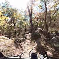
Longer ride through some of the best technical trails in Oak Mountain State Park

Detailed Description
Oak Mountain Tech Loop is a 27 mile popular expert route located near Pelham Alabama. This mountain bike only route. This route includes 14 trails. This route climbs 2,424 ft with a max elevation of 1,258 ft then descends -2,422 ft.

Trail Issues on Route

  • Significant Issue / Amber: 2 trails (newest: May 1, 2026)
  • Minor Issue / Yellow: 3 trails (newest: Jun 24, 2026)
Local Trail Association
Local trail association
Birmingham Urban Mountain Pedalers (bump.org)
Please consider joining or donating to the local riding association to support trail development & maintenance.
Donate to earn trail karma!

Stats

  • Distance
    27 miles
  • Avg time
    2 hr 36 min
  • Altitude change
    2 ft
  • Altitude min
    507 ft
  • Altitude start
    555 ft
  • Altitude end
    558 ft
  • Climb
    2,424 ft
  • Descent
    -2,422 ft
  • Grade max
    -30.2%
  • Grade min
    46.2%
  • Distance climb
    11 miles
  • Distance down
    12 miles
  • Distance flat
    4 miles

46 Reviews & Comments


We hope you've been enjoying Trailforks!

Create a FREE account to view route comments and much more.

Trails in Route

Details

Avg: 5 (1 votes)
close
3D
Trail Conditions
  • Unknown
  • Snow Groomed
  • Snow Packed
  • Snow Covered
  • Snow Cover Partial
  • Freeze/thaw Cycle
  • Icy
  • Prevalent Mud
  • Wet
  • Variable
  • Ideal
  • Dry
  • Very Dry
Trail Flow (Ridden Direction)
Trailforks scans users ridelogs to determine the most popular direction each trail is ridden. A good flowing trail network will have most trails flowing in a single direction according to their intension.
The colour categories are based on what percentage of riders are riding a trail in its intended direction.
  • > 96%
  • > 90%
  • > 80%
  • > 70%
  • > 50%
  • < 50%
  • bi-directional trail
  • no data
Trail Last Ridden
Trailforks scans ridelogs to determine the last time a trail was ridden.
  • < 2 days
  • < 1 week
  • < 2 weeks
  • < 1 month
  • < 6 months
  • > 6 months
Trail Ridden Direction
The intended direction a trail should be ridden.
  • Downhill Only
  • Downhill Primary
  • Both Directions
  • Uphill Primary
  • Uphill Only
  • One Direction
Contribute Details
Colors indicate trail is missing specified detail.
  • Description
  • Photos
  • Description & Photos
  • Videos
Trail Popularity ?
Trailforks scans ridelogs to determine which trails are ridden the most in the last 9 months. Trails are compared with nearby trails in the same city region with a possible 25 colour shades. Think of this as a heatmap, more rides = more kinetic energy = warmer colors.
  • most popular
  • popular
  • less popular
  • not popular
ATV/ORV/OHV Filter
Max Vehicle Width
inches
US Cell Coverage
Legend
cell carrier legend

Radar Time
Activity Recordings
Trailforks uses anonymized public activity data. ?
Activity Recordings
Trailforks uses anonymized public activity data. ?
Personal Heatmap
Activity Types
all / none
Options
2
Date range month
Winter Trails
Warning A routing network for winter maps does not exist. Selecting trails using the winter trails layer has been disabled.
Missing Trails
Most Popular
Least Popular
Trails are colored based on popularity. The more popular a trail is, the more red. Less popular trails trend towards green.
Jump Magnitude Heatmap
Heatmap of where riders jump on trails. Zoom in to see individual jumps, click circles to view jump details.
BC Backroad Status

Service Road Atlas is a free to use, community-driven service for viewing and creating reports on the numerous back-country service roads around B.C. and Alberta.

map legend
Slope Aspect
Direction the slope faces
Flat N NE E SE S SW W NW
Trails Deemphasized
Trails are shown in grey.
disable
Only show trails with no bike usage.
Enable
Suggested Layers
Based on selected activity type

    Save the current map location and zoom level as your default home location whenever this page is loaded.

    Save
    Trail transparency
    • Singletrack
    • Unpaved
    38
    68
    57
    83
    Best Flow Trail in Oak Mountain State Park? |...
    Best Flow Trail in Oak Mountain State Park? | Lightning Trail Preview
    trail: Lightning
    4:01 | 86 | comments: 0 | favs:
    Apr 30, 2026
    Tree hugging
    Tree hugging
    0:10 | 267 | comments: 0 | favs:
    Dec 5, 2021
    Don’t go as slow as I did:)

    Recent Trail Reports Along Route

    statustraildateconditiondescription
    Johnsons Mountain
    Jun 27, 2026 @ 7:47am (America/Chicago)
    3 hours
    tree
    Foreplay
    Jun 24, 2026 @ 5:30pm (America/Chicago)
    3 days
    Too much steeze in the corner made the tree fall. Sorry guys.
    Seven Bridges
    Jun 15, 2026 @ 2:04pm (America/Chicago)
    Jun 15, 2026
    Trail Crew cleared mud off of S-5 6/15/26
    reporter
    Boulder Ridge
    May 31, 2026 @ 7:41pm (America/Chicago)
    May 31, 2026
    Overgrown vegetation
    Garrett's Gulch
    May 1, 2026 @ 12:15pm (America/Chicago)
    May 1, 2026
    Tree down across trail
    more reports »
    • By rpearce1475TF Pro & contributors
    • #4343 - 2,322 views

    Hit the Trail

    Open in App

    Get this route on your phone instantly.

    Download Route

    Save to wishlist, Garmin & download.