3.7 miles
Distance
1,358 ft
Climb
-1,360 ft
Descent
1,610 ft
High Point
-2 ft
Altitude change
729 ft
Altitude min
730 ft
Altitude start
728 ft
Altitude end
-97.3%
Grade max
48.5%
Grade min
2 miles
Distance climb
1 mile
Distance down
866 ft
Distance flat

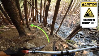
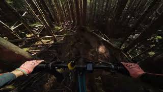
Ride technical downhill trails with no mandatory airs. Probably the longest time spent descending compared to climbing for a quick ride.

Detailed Description
Techy Time is a 4 mile less popular expert route located near Terrace British Columbia. This mountain bike only route. This route includes 25 trails. This route climbs 1,358 ft with a max elevation of 1,610 ft then descends -1,360 ft.

Trail Issues on Route

  • Closed: 1 trail (newest: May 22, 2026)
Local Trail Association
Local trail association
Terrace Off Road Cycling Association (www.torcanorth.com)
Please consider joining or donating to the local riding association to support trail development & maintenance.
Donate to earn trail karma!

Stats

  • Distance
    4 miles
  • Avg time
    50 min 20 sec
  • Altitude change
    -2 ft
  • Altitude min
    729 ft
  • Altitude start
    730 ft
  • Altitude end
    728 ft
  • Climb
    1,358 ft
  • Descent
    -1,360 ft
  • Grade max
    -97.3%
  • Grade min
    48.5%
  • Distance climb
    2 miles
  • Distance down
    1 mile
  • Distance flat
    866 ft

5 Reviews & Comments


We hope you've been enjoying Trailforks!

Create a FREE account to view route comments and much more.

Trails in Route

4 noobs4,232 ft
Access Road2,657 ft
Packhorse449 ft
Wade's World1,148 ft
4 noobs1,939 ft
Access Road5,013 ft
Sexecutioner1,207 ft
Packhorse558 ft
Jet boy518 ft
Leftovers935 ft

Details

  • Riding area
  • Primary Activity
    Mountain Bike
  • Difficulty rating
    Black Diamond
  • Ridelogs
    20
no votes yet
close
3D
Trail Conditions
  • Unknown
  • Snow Groomed
  • Snow Packed
  • Snow Covered
  • Snow Cover Partial
  • Freeze/thaw Cycle
  • Icy
  • Prevalent Mud
  • Wet
  • Variable
  • Ideal
  • Dry
  • Very Dry
Trail Flow (Ridden Direction)
Trailforks scans users ridelogs to determine the most popular direction each trail is ridden. A good flowing trail network will have most trails flowing in a single direction according to their intension.
The colour categories are based on what percentage of riders are riding a trail in its intended direction.
  • > 96%
  • > 90%
  • > 80%
  • > 70%
  • > 50%
  • < 50%
  • bi-directional trail
  • no data
Trail Last Ridden
Trailforks scans ridelogs to determine the last time a trail was ridden.
  • < 2 days
  • < 1 week
  • < 2 weeks
  • < 1 month
  • < 6 months
  • > 6 months
Trail Ridden Direction
The intended direction a trail should be ridden.
  • Downhill Only
  • Downhill Primary
  • Both Directions
  • Uphill Primary
  • Uphill Only
  • One Direction
Contribute Details
Colors indicate trail is missing specified detail.
  • Description
  • Photos
  • Description & Photos
  • Videos
Trail Popularity ?
Trailforks scans ridelogs to determine which trails are ridden the most in the last 9 months. Trails are compared with nearby trails in the same city region with a possible 25 colour shades. Think of this as a heatmap, more rides = more kinetic energy = warmer colors.
  • most popular
  • popular
  • less popular
  • not popular
ATV/ORV/OHV Filter
Max Vehicle Width
inches
US Cell Coverage
Legend
cell carrier legend

Radar Time
Activity Recordings
Trailforks uses anonymized public activity data. ?
Activity Recordings
Trailforks uses anonymized public activity data. ?
Personal Heatmap
Activity Types
all / none
Options
2
Date range month
Winter Trails
Warning A routing network for winter maps does not exist. Selecting trails using the winter trails layer has been disabled.
Missing Trails
Most Popular
Least Popular
Trails are colored based on popularity. The more popular a trail is, the more red. Less popular trails trend towards green.
Jump Magnitude Heatmap
Heatmap of where riders jump on trails. Zoom in to see individual jumps, click circles to view jump details.
BC Backroad Status

Service Road Atlas is a free to use, community-driven service for viewing and creating reports on the numerous back-country service roads around B.C. and Alberta.

map legend
Slope Aspect
Direction the slope faces
Flat N NE E SE S SW W NW
Trails Deemphasized
Trails are shown in grey.
disable
Only show trails with no bike usage.
Enable
Suggested Layers
Based on selected activity type

    Save the current map location and zoom level as your default home location whenever this page is loaded.

    Save
    Trail transparency
    • Singletrack
    • Unpaved
    28
    219 | 1 faves
    233
    141
    youtuber DON'T RIDE HERE...
    DON'T RIDE HERE...
    42:51 | 42 | comments: 0 | favs:
    Dec 10, 2025
    Copper Mountain | Terrace, BC
    Copper Mountain | Terrace, BC
    trail: Leftovers
    13:24 | 64 | comments: 0 | favs:
    Jan 30, 2025

    Recent Trail Reports Along Route

    statustraildateconditiondescription
    Packhorse
    Jun 27, 2026 @ 6:38pm (America/Vancouver)
    Jun 27, 2026
    Bridges across the slide are amazing. The work is much appreciated.
    Wade's World
    May 22, 2026 @ 8:34pm (America/Vancouver)
    May 22, 2026
    Bottom section of the trail got caught in the 2024 carnage, major debris flow across the trail
    Leftovers
    Jul 24, 2025 @ 7:23am
    Jul 24, 2025
    This trail is open again. It has a huge lily pad and a few drops and jumps. This trail has double black features. Best not to hit anything blind.
    Sexecutioner
    Jul 2, 2025 @ 1:18pm
    Jul 2, 2025
    POST SLIDE: Trail can be completed by exiting packhorse via Lil jump run.
    4 noobs
    Jul 2, 2025 @ 1:10pm
    Jul 2, 2025
    more reports »
    • By lovetoridebikesTF Pro & contributors
    • #26533 - 493 views

    Hit the Trail

    Open in App

    Get this route on your phone instantly.

    Download Route

    Save to wishlist, Garmin & download.