This trail is permanently closed/decommissioned
more stats
935 ft
Distance
-137 ft
Descent
00:01:19
Avg time
-137 ft
Altitude change
729 ft
Altitude min
865 ft
Altitude max
865 ft
Altitude start
728 ft
Altitude end
-14.6%
Grade
-52.5%
Grade max
1.6%
Grade min
26 ft
Distance climb
758 ft
Distance down
151 ft
Distance flat
00:01:19
Avg time

Leftovers Details

  • Activities
    • Mountain Bike
    • Hike
    • Trail Running
  • Riding Area
    Copper Mountain
    Terrace, British Columbia
  • Difficulty Rating
  • Local Popularity
    65 in Mountain Biking [+]
    • 5 in Trail Running
    • 65 in Hiking
  • Trail Type
    Singletrack
  • Bike Type
    DH, AM
  • Dogs Allowed
    Yes
  • eBike Allowed
  • TTFs on Trail
    Berm, Bridge, Jump, Ladder Bridge
  • Land Owner
    Recreation Sites and Trails BC

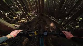
Trail starts out off the 4noobs road with a couple tighter bermy corners. If you stay right after the first few berms there is a separate trail with fun jumps but this route tends to be wet and muddy. There's an old log ride on the ground that was turned into a ladder bridge next that leads into the jumps. If you stay left there's no gaps but go hard right and there is.

Access Info

Cuts off 4 noobs.

This trail is unsanctioned.

Traditionally Indigenous Territory

Recent Activity on Trail

Past Week
  • 0 rides
  •  
6 Months
  • 2 rides
  • 4 miles avg distance
All
  • 28 rides
  • Last: Jun 29, 2026
c1c2c3c4
January
February
March
April
May
June
July
August
September
October
November
December
update trails status or condition

Leftovers Trail Reports

statusdatedescription
Jul 24, 2025 @ 7:23am
Jul 24, 2025
This trail is open again. It has a huge lily pad and a few drops and jumps. This trail has double black features. Best not to hit anything blind.
May 14, 2025 @ 3:44pm
May 14, 2025
90% of this trail was taken out by a massive landslide in fall 2024. RIP leftovers.
Mar 30, 2024 @ 10:12pm
Mar 30, 2024
Ready for the season
Apr 23, 2023 @ 5:03am
Apr 23, 2023
Perfect conditions.
Dec 11, 2020 @ 10:08pm
Dec 11, 2020
A little soft on the loamy strait lines, the original trail route is great and the bridge work is strong.
more »
Status:
on Jul 24, 2025
Dry
Avg: 3.99 (2 votes)
Your vote: 0

view (541)
close
3D
Trail Conditions
  • Unknown
  • Snow Groomed
  • Snow Packed
  • Snow Covered
  • Snow Cover Partial
  • Freeze/thaw Cycle
  • Icy
  • Prevalent Mud
  • Wet
  • Variable
  • Ideal
  • Dry
  • Very Dry
Trail Flow (Ridden Direction)
Trailforks scans users ridelogs to determine the most popular direction each trail is ridden. A good flowing trail network will have most trails flowing in a single direction according to their intension.
The colour categories are based on what percentage of riders are riding a trail in its intended direction.
  • > 96%
  • > 90%
  • > 80%
  • > 70%
  • > 50%
  • < 50%
  • bi-directional trail
  • no data
Trail Last Ridden
Trailforks scans ridelogs to determine the last time a trail was ridden.
  • < 2 days
  • < 1 week
  • < 2 weeks
  • < 1 month
  • < 6 months
  • > 6 months
Trail Ridden Direction
The intended direction a trail should be ridden.
  • Downhill Only
  • Downhill Primary
  • Both Directions
  • Uphill Primary
  • Uphill Only
  • One Direction
Contribute Details
Colors indicate trail is missing specified detail.
  • Description
  • Photos
  • Description & Photos
  • Videos
Trail Popularity ?
Trailforks scans ridelogs to determine which trails are ridden the most in the last 9 months. Trails are compared with nearby trails in the same city region with a possible 25 colour shades. Think of this as a heatmap, more rides = more kinetic energy = warmer colors.
  • most popular
  • popular
  • less popular
  • not popular
ATV/ORV/OHV Filter
Max Vehicle Width
inches
US Cell Coverage
Legend
cell carrier legend

Radar Time
Activity Recordings
Trailforks uses anonymized public activity data. ?
Activity Recordings
Trailforks uses anonymized public activity data. ?
Personal Heatmap
Activity Types
all / none
Options
2
Date range month
Winter Trails
Warning A routing network for winter maps does not exist. Selecting trails using the winter trails layer has been disabled.
Missing Trails
Most Popular
Least Popular
Trails are colored based on popularity. The more popular a trail is, the more red. Less popular trails trend towards green.
Jump Magnitude Heatmap
Heatmap of where riders jump on trails. Zoom in to see individual jumps, click circles to view jump details.
BC Backroad Status

Service Road Atlas is a free to use, community-driven service for viewing and creating reports on the numerous back-country service roads around B.C. and Alberta.

map legend
Slope Aspect
Direction the slope faces
Flat N NE E SE S SW W NW
Trails Deemphasized
Trails are shown in grey.
disable
Only show trails with no bike usage.
Enable
Suggested Layers
Based on selected activity type

    Save the current map location and zoom level as your default home location whenever this page is loaded.

    Save
        Directions to leftovers trailhead (54.488050, -128.467680)

        Photos

        5 more »
        28 |
        Aug 6, 2025 @ 9:29am
        Aug 6, 2025
        271 |
        Jul 5, 2010 @ 9:46am
        Jul 5, 2010
        359 |
        Jul 5, 2010 @ 9:46am
        Jul 5, 2010
        252 |
        Jun 7, 2014 @ 11:48am
        Jun 7, 2014

        Videos

        1 more »
        Copper Mountain | Terrace, BC
        13:24 | 64 | Jan 30, 2025 , Terrace

        Routes with this trail

        8 miles 2,702 ft 49
        If you are in the area for a good time but not a long time, this route will show you the best copper...
        7 miles 2,829 ft 44
        The diamond, four expert trails that are arguably the best steep trails on copper mountain.
        4 miles 1,358 ft 25
        Ride technical downhill trails with no mandatory airs. Probably the longest time spent descending compared...

        1 Review & Comments


        We hope you've been enjoying Trailforks!

        Create a FREE account to view trail comments and much more.

        • #95876 - 1,227 views

        Frequently Asked Questions About Leftovers

        Where is Leftovers located?
        Leftovers is located in Copper Mountain, Terrace, British Columbia, Canada. It is part of the Copper Mountain trail network. The trailhead is located at coordinates 54.48805, -128.46768.
        How hard is Leftovers?
        Leftovers is rated as Blue difficulty. The average grade is 14.6%.
        What is the elevation gain for Leftovers?
        The trail has 137 ft of elevation descent. The elevation ranges from 729 ft to 865 ft.
        How long is Leftovers?
        Leftovers is 935 ft long. The trail type is singletrack.

        Hit the Trail

        Open in App

        Get this trail on your phone instantly.
        open trail in app

        Download Trail

        Save to wishlist, Garmin & download.
        save the trail

        Find Related Routes

        Find routes and users activities that include this trail.
        find routes for this trail

        You must enter a description before submitting.