4.6 miles
Distance
108 ft
Climb
-894 ft
Descent
5,092 ft
High Point
-786 ft
Altitude change
4,305 ft
Altitude min
5,092 ft
Altitude start
4,304 ft
Altitude end
-3.2%
Grade
-26.8%
Grade max
9.1%
Grade min
4,373 ft
Distance climb
3 miles
Distance down
4,216 ft
Distance flat

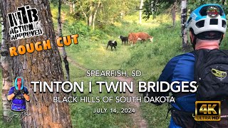
Shuttle up to the Aspen Hills rd. and ride the Tinton Trail back to the lower Tinton Trailhead, or all the way back to town. This is a fun way to experience Tinton without the steep climbs.

Detailed Description
Tinton Shuttle is a 5 mile popular intermediate route located near Spearfish South Dakota. This mountain bike only route. This route includes 1 trails. This route climbs 108 ft with a max elevation of 5,092 ft then descends -894 ft.
Local Trail Association
Local trail association
Ridge Riders of Black Hills Mountain Bike Club (ridgeridersblackhills.blogspot.com)
Please consider joining or donating to the local riding association to support trail development & maintenance.
Donate to earn trail karma!

Stats

  • Distance
    5 miles
  • Altitude change
    -786 ft
  • Altitude min
    4,305 ft
  • Altitude start
    5,092 ft
  • Altitude end
    4,304 ft
  • Climb
    108 ft
  • Descent
    -894 ft
  • Grade
    -3.2%
  • Grade max
    -26.8%
  • Grade min
    9.1%
  • Distance climb
    4,373 ft
  • Distance down
    3 miles
  • Distance flat
    4,216 ft

1 Review & Comments


We hope you've been enjoying Trailforks!

Create a FREE account to view route comments and much more.

Trails in Route

Tinton Trail5 miles

Details

Directions

  1. Walk southeast on Super D.
  2. Continue for 5 kilometers.
  3. Keep right to take Tinton Trail.
  4. Continue for 2.5 kilometers.
no votes yet
close
3D
Trail Conditions
  • Unknown
  • Snow Groomed
  • Snow Packed
  • Snow Covered
  • Snow Cover Partial
  • Freeze/thaw Cycle
  • Icy
  • Prevalent Mud
  • Wet
  • Variable
  • Ideal
  • Dry
  • Very Dry
Trail Flow (Ridden Direction)
Trailforks scans users ridelogs to determine the most popular direction each trail is ridden. A good flowing trail network will have most trails flowing in a single direction according to their intension.
The colour categories are based on what percentage of riders are riding a trail in its intended direction.
  • > 96%
  • > 90%
  • > 80%
  • > 70%
  • > 50%
  • < 50%
  • bi-directional trail
  • no data
Trail Last Ridden
Trailforks scans ridelogs to determine the last time a trail was ridden.
  • < 2 days
  • < 1 week
  • < 2 weeks
  • < 1 month
  • < 6 months
  • > 6 months
Trail Ridden Direction
The intended direction a trail should be ridden.
  • Downhill Only
  • Downhill Primary
  • Both Directions
  • Uphill Primary
  • Uphill Only
  • One Direction
Contribute Details
Colors indicate trail is missing specified detail.
  • Description
  • Photos
  • Description & Photos
  • Videos
Trail Popularity ?
Trailforks scans ridelogs to determine which trails are ridden the most in the last 9 months. Trails are compared with nearby trails in the same city region with a possible 25 colour shades. Think of this as a heatmap, more rides = more kinetic energy = warmer colors.
  • most popular
  • popular
  • less popular
  • not popular
ATV/ORV/OHV Filter
Max Vehicle Width
inches
US Cell Coverage
Legend
cell carrier legend

Radar Time
Activity Recordings
Trailforks uses anonymized public activity data. ?
Activity Recordings
Trailforks uses anonymized public activity data. ?
Personal Heatmap
Activity Types
all / none
Options
2
Date range month
Winter Trails
Warning A routing network for winter maps does not exist. Selecting trails using the winter trails layer has been disabled.
Missing Trails
Most Popular
Least Popular
Trails are colored based on popularity. The more popular a trail is, the more red. Less popular trails trend towards green.
Jump Magnitude Heatmap
Heatmap of where riders jump on trails. Zoom in to see individual jumps, click circles to view jump details.
BC Backroad Status

Service Road Atlas is a free to use, community-driven service for viewing and creating reports on the numerous back-country service roads around B.C. and Alberta.

map legend
Slope Aspect
Direction the slope faces
Flat N NE E SE S SW W NW
Trails Deemphasized
Trails are shown in grey.
disable
Only show trails with no bike usage.
Enable
Suggested Layers
Based on selected activity type

    Save the current map location and zoom level as your default home location whenever this page is loaded.

    Save
    Trail transparency
    • Singletrack
    386
    294
    320
    332
    Supercal 9.9 XTR med
    Supercal 9.9 XTR med
    0:19 | 6 | comments: 0 | favs:
    Jan 22, 2026
    Xc bike

    Recent Trail Reports Along Route

    statustraildateconditiondescription
    Tinton Trail
    Jun 1, 2025 @ 6:33am
    Jun 1, 2025
    reporter
    more reports »
    • By HeathscliffTF Pro STA & contributors
    • #66946 - 69 views

    Hit the Trail

    Open in App

    Get this route on your phone instantly.

    Download Route

    Save to wishlist, Garmin & download.