
14.7 miles
Distance
1,177 ft
Climb
-1,180 ft
Descent
6,302 ft
High Point
-1 ft
Altitude change
5,955 ft
Altitude min
6,058 ft
Altitude start
6,056 ft
Altitude end
-20.4%
Grade max
35%
Grade min
6 miles
Distance climb
5 miles
Distance down
3 miles
Distance flat

Ride at your own risk. 35 dollar yearly permit required if you cross state trust lands.

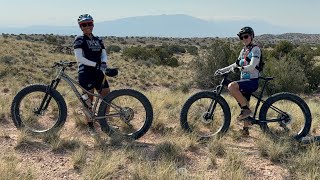
This upper loop is where the soil is much more stable than within the badlands. It consists of very narrow singletrack, some sandy arroyo crossings and lots of cactus. Trails ARE DIRECTIONAL. This trail system is for seasoned trail riders with a good set of advanced skills under their belt. Be self contained and have all the tools and supplies needed if something goes wrong. This is in the middle of nowhere and the desert can eat you up and spit you out if you are not 100% prepared. Read all signs and respect the trails. Keep it narrow. Leave it like you found it with minimum impact. Please stay on the trail and off the cryptobiotic crust to help slow erosion in this area. Fat tires are not required for this upper loop but recommended. Fat bikes are required within the badlands to help minimize trail damage and erosion. Keep singletrack single. Beware of snakes bears and mountain lions that occasionally pass through this area.

Detailed Description
Upper loop is a 15 mile popular intermediate route located near Rio Rancho New Mexico. This mountain bike only route can be used one direction and has a hard overall physical rating. This route includes 8 trails. This route climbs 1,177 ft with a max elevation of 6,302 ft then descends -1,180 ft.
Tags
DesertSandy
Route Supporters

Local Trail Association

Local trail association
Mariposa Fat Bike Society (www.facebook.com)
Please consider joining or donating to the local riding association to support trail development & maintenance.
Donate to earn trail karma!

Stats

  • Distance
    15 miles
  • Avg time
    2 hr 11 min
  • Altitude min
    5,955 ft
  • Altitude start
    6,058 ft
  • Altitude end
    6,056 ft
  • Climb
    1,177 ft
  • Descent
    -1,180 ft
  • Grade max
    -20.4%
  • Grade min
    35%
  • Distance climb
    6 miles
  • Distance down
    5 miles
  • Distance flat
    3 miles

5 Reviews & Comments

Aps79
Someone put some effort into these “trails”. They ride more like poorly marked fame trails. Easy to get lost despite all the signs. They are loose, poorly defined and not that much fun. Not really worth the drive from town. Wouldnt ride here again

We hope you've been enjoying Trailforks!

Create a FREE account to view all route reviews and much more.

Trails in Route

Details

  • Riding area
  • Primary Activity
    Mountain Bike
  • Difficulty rating
    Blue
  • Route Type
    Loop
  • Bike type
    AM, XC, Fat
  • Direction
    One Direction
  • Physical rating
    Hard
Avg: 3 (2 votes)
close
Trail transparency
  • Singletrack
New Mexico Monsoon
mtb
New Mexico Monsoon
2:58 | 81 | comments: 0 | favs:
Aug 9, 2025
Fat Biking New Mexico With Skydio2
mtb
Fat Biking New Mexico With Skydio2
24:24 | 745 | comments: 0 | favs:
Apr 30, 2021

Recent Trail Reports Along Route

statustraildateconditiondescription
Middle Reservoir
Oct 26, 2026 @ 5:13pm (America/Ciudad_Juarez)
Oct 26, 2026
Tres Caballos
Oct 25, 2026 @ 9:50am (America/Ciudad_Juarez)
Oct 25, 2026
Jack Rabbit Ridge
Oct 25, 2026 @ 9:50am (America/Ciudad_Juarez)
Oct 25, 2026
Overlook
Jun 15, 2026 @ 9:23am (America/Ciudad_Juarez)
Jun 15, 2026
Bitchin Bridges
Mar 28, 2026 @ 5:50pm (America/Denver)
Mar 28, 2026
more reports »
  • By TerraFormerTF Pro MFBS & contributors
  • #7553 - 1,244 views

Hit the Trail

Open in App

Get this route on your phone instantly.

Download Route

Save to wishlist, Garmin & download.