Supporters, Builders, Maintainers & Land Managers of Bam-Ba-Lam Trail
- past supporters
Pineapple Express Adventure Rides
2017 - 2019Sponsor
Ptarmigan Ptrails
2019Builder
Wild Rivers Coast Mountain Bicycling Association
2017 - 2019Maintainer
Bam-Ba-Lam Details
-
Activities
- Mountain Bike
-
Riding AreaWhiskey Run Trails
Coos Bay, Oregon -
Difficulty Rating
-
Voted DifficultyBlue (1 vote)
-
Trail TypeSingletrack
-
Bike TypeAM
-
DirectionDownhill OnlyPopular direction shown
-
Physical RatingModerate
-
Trail VisibilityAlways easy to follow
-
SeasonDry Season
-
eBike Allowed
-
TTFs on TrailBerm, Drop, Jump, Gap Jump
-
Global Ranking#8914 in Mountain Biking
-
Local Popularity90 in Mountain Biking
-
Year Opened2019
-
Land OwnerCoos County Forest
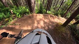
Get ready to fly through the forest and over the ferns with this Black Diamond, downhill only trail which starts off with a large 3-4' drop off an old tree. You'll want to pedal hard off the start so you don't OTB (the drop is not "rollable"). Enjoy sweeping, sculpted berms and a trail with option lines to jump gaps or stick to carving the clay berms. This trail gets fast and is designed to allow you to carry your speed and lay into the large berms and air over the jumps. Bam-Ba-Lam exits at the bottom of Copperhead Road for an easy climb back up. A two-way blue trail will also join at this lower intersection but is not completed yet. Please do not ride closed trails.
Please only ride when dry
Do not walk up the trail!
Access Info
Drop into Bam-Ba-Lam from Copperhead Road. Descend down the east side from the main parking lot area off Whiskey Run Road onto Copperhead Road and continue all the way until the trail crosses a Logging Road. Copperhead Road continues along the tree line towards the right, while Bam-Ba-Lam cuts off left.
Disclaimer
Absolutely NO DOGS. No Walking. Downhill only!
Local Trail Association
-
Please consider joining or donating to the local trail association to supportdonate to earn trail karma!
trail development & maintenance.
Traditionally Indigenous Territory
More Stats for Bam-Ba-Lam mountain bike trail trail
-
Altitude change-202 ft
-
Altitude min130 ft
-
Altitude max338 ft
-
Altitude start338 ft
-
Altitude end136 ft
-
Grade-10.209%
-
Grade max-31.413%
-
Grade min28.195%
-
Distance climb314 ft
-
Distance down1,646 ft
-
Distance flat19 ft
-
Avg time00:02:05
-
Avg reverse time00:04:59
- view trail stats
- Unknown
- Snow Groomed
- Snow Packed
- Snow Covered
- Snow Cover Inadequate
- Freeze/thaw Cycle
- Icy
- Prevalent Mud
- Wet
- Variable
- Ideal
- Dry
- Very Dry
The colour categories are based on what percentage of riders are riding a trail in its intended direction.
- > 96%
- > 90%
- > 80%
- > 70%
- > 50%
- < 50%
- bi-directional trail
- no data
- < 2 days
- < 1 week
- < 2 weeks
- < 1 month
- < 6 months
- > 6 months
- Downhill Only
- Downhill Primary
- Both Directions
- Uphill Primary
- Uphill Only
- One Direction
- Description
- Photos
- Description & Photos
- Videos
- most popular
- popular
- less popular
- not popular
- mountain biking recent
- mountain biking (>6 month)
- hiking (1 year)
- moto (1 year)
- Downhill Ski
- Backcountry Ski
- Nordic Ski
- Snowmobile
Save the current map location and zoom level as your default home location whenever this page is loaded.
SaveBam-Ba-Lam Trail Reports
Recent Ridelog Activity on Trail
Past Week
- 2 rides
- 10 miles avg distance
6 Months
- 81 rides
- 11 miles avg distance
All
- 977 rides
- Last: Mar 28, 2023
Routes with this trail
3 Reviews & Comments
We hope you've been enjoying Trailforks!
Create a FREE account to view trail comments and much more.
Nearby Trails
- New Bones 148 ft
- The Bowls Pumptrack 328 ft
- Upper Reboot 659 ft
- The Onceler 820 ft
- Old Bones 1,004 ft
- embed Bam-Ba-Lam trail on your website
- By whiskeyqueen
WRCMBA & contributors
- #186788 - 1,921 views
- subscribe
- login to download gpx or kml files.