more stats
1.1 miles
Distance
48 ft
Climb
-569 ft
Descent
00:04:12
Avg time
-521 ft
Altitude change
601 ft
Altitude min
1,122 ft
Altitude max
1,122 ft
Altitude start
600 ft
Altitude end
-9%
Grade
-41.2%
Grade max
18.9%
Grade min
541 ft
Distance climb
4,094 ft
Distance down
1,158 ft
Distance flat
00:04:12
Avg time

Barbro Details

  • Activities
    • Mountain Bike
  • Riding Area
  • Difficulty Rating
  • Local Popularity
    95 in Mountain Biking
  • Global Ranking
    #130 in Mountain Biking
  • Trail Type
    Machine Groomed
  • Bike Type
    DH, AM
  • Direction
    Downhill Only
    Popular Direction Shown
  • Physical Rating
    Easy
  • TTFs on Trail
    Berm, Jump, Wallride

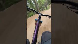
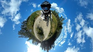
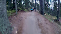
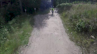
Den här leden är precis vad Järvsö Bergscykel Park står för – cykling för alla. Det finns stora velodromkurvor, sköna hopp sugande nedförsbackar och spännande utmaningar. I Barbro trivs alla sorters cyklister, allt ifrån fullblodsproffs till barnfamiljen som provar på downhill för första gången.

Inför säsongen 2021 har Barbro fått tillbaka sin wallride, och arbete har gjorts för att göra sträckan under de första broarna, mot "stora bermen" roligare med några mindre hopp, berms samt både step-down och step-up.

Bike Park

Traditionally Indigenous Territory

Recent Activity on Trail

Past Week
  • 18 rides
  • 24.2 km average
6 Months
  • 69 rides
  • 28.4 km avg distance
All
  • 818 rides
  • Last: Jun 26, 2026
c1c2c3c4
January
February
March
April
May
June
July
August
September
October
November
December
Status:
on Jun 8, 2026
Ideal
Avg: 4.54 (19 votes)
Your vote: 0

view (41,671)
close
3D
Trail Conditions
  • Unknown
  • Snow Groomed
  • Snow Packed
  • Snow Covered
  • Snow Cover Partial
  • Freeze/thaw Cycle
  • Icy
  • Prevalent Mud
  • Wet
  • Variable
  • Ideal
  • Dry
  • Very Dry
Trail Flow (Ridden Direction)
Trailforks scans users ridelogs to determine the most popular direction each trail is ridden. A good flowing trail network will have most trails flowing in a single direction according to their intension.
The colour categories are based on what percentage of riders are riding a trail in its intended direction.
  • > 96%
  • > 90%
  • > 80%
  • > 70%
  • > 50%
  • < 50%
  • bi-directional trail
  • no data
Trail Last Ridden
Trailforks scans ridelogs to determine the last time a trail was ridden.
  • < 2 days
  • < 1 week
  • < 2 weeks
  • < 1 month
  • < 6 months
  • > 6 months
Trail Ridden Direction
The intended direction a trail should be ridden.
  • Downhill Only
  • Downhill Primary
  • Both Directions
  • Uphill Primary
  • Uphill Only
  • One Direction
Contribute Details
Colors indicate trail is missing specified detail.
  • Description
  • Photos
  • Description & Photos
  • Videos
Trail Popularity ?
Trailforks scans ridelogs to determine which trails are ridden the most in the last 9 months. Trails are compared with nearby trails in the same city region with a possible 25 colour shades. Think of this as a heatmap, more rides = more kinetic energy = warmer colors.
  • most popular
  • popular
  • less popular
  • not popular
ATV/ORV/OHV Filter
Max Vehicle Width
inches
US Cell Coverage
Legend
cell carrier legend

Radar Time
Activity Recordings
Trailforks uses anonymized public activity data. ?
Activity Recordings
Trailforks uses anonymized public activity data. ?
Personal Heatmap
Activity Types
all / none
Options
2
Date range month
Winter Trails
Warning A routing network for winter maps does not exist. Selecting trails using the winter trails layer has been disabled.
Missing Trails
Most Popular
Least Popular
Trails are colored based on popularity. The more popular a trail is, the more red. Less popular trails trend towards green.
Jump Magnitude Heatmap
Heatmap of where riders jump on trails. Zoom in to see individual jumps, click circles to view jump details.
BC Backroad Status

Service Road Atlas is a free to use, community-driven service for viewing and creating reports on the numerous back-country service roads around B.C. and Alberta.

map legend
Slope Aspect
Direction the slope faces
Flat N NE E SE S SW W NW
Trails Deemphasized
Trails are shown in grey.
disable
Only show trails with no bike usage.
Enable
Suggested Layers
Based on selected activity type

    Save the current map location and zoom level as your default home location whenever this page is loaded.

    Save
        Directions to barbro trailhead (61.716090, 16.146980)

        Photos

        10 more »
        190 |
        Nov 18, 2017 @ 9:40am
        Nov 18, 2017
        175 |
        Jun 7, 2017 @ 9:52am
        Jun 7, 2017
        236 |
        May 27, 2021 @ 2:31am
        May 27, 2021
        162 |
        May 27, 2021 @ 2:31am
        May 27, 2021

        Videos

        9 more »
        First timer downhill JBP barbro
        3:16 | 113 | Aug 10, 2024 , Ljusdal
        Järvsö BikePark Ur Ett Annorlunda Perspektiv...
        2:26 | 401 | Mar 17, 2020 , Ljusdal
        crash at JBP
        0:13 | 134 | Oct 6, 2020 , Ljusdal
        12-year old Alex.
        0:00 | 95 | Aug 13, 2019 , Ljusdal

        1 Review & Comments


        We hope you've been enjoying Trailforks!

        Create a FREE account to view trail comments and much more.

        • By maciek1998TF Pro & contributors
        • #54787 - 3,917 views

        Frequently Asked Questions About Barbro

        Where is Barbro located?
        Barbro is located in Järvsö Bergscykel Park, Ljusdal, Sweden. It is part of the Järvsö Bergscykel Park trail network. The trailhead is located at coordinates 61.71609, 16.14698.
        How hard is Barbro?
        Barbro is rated as Blue difficulty. The physical rating is Easy. The average grade is 9%.
        What is the elevation gain for Barbro?
        Barbro has 48 ft of elevation gain. The trail has 569 ft of elevation descent. The elevation ranges from 601 ft to 1,122 ft.
        Is Barbro a point to point trail?
        Yes, Barbro is a point to point trail. The direction is Downhill Only. The trail type is machine groomed.

        Hit the Trail

        Open in App

        Get this trail on your phone instantly.
        open trail in app

        Download Trail

        Save to wishlist, Garmin & download.
        save the trail

        Find Related Routes

        Find routes and users activities that include this trail.
        find routes for this trail

        You must enter a description before submitting.