This trail is permanently closed/decommissioned
more stats
3,848 ft
Distance
8 ft
Climb
-977 ft
Descent
00:14:24
Avg time
-969 ft
Altitude change
961 ft
Altitude min
1,930 ft
Altitude max
1,930 ft
Altitude start
961 ft
Altitude end
-25.2%
Grade
-116%
Grade max
9.6%
Grade min
102 ft
Distance climb
3,691 ft
Distance down
56 ft
Distance flat
00:14:24
Avg time

Beaster Details

  • Activities
    • Mountain Bike
    • E-Bike
    • Hike
    • Trail Running
  • Riding Area
    Nesbyen sentrum
    Nesbyen
  • AKA
    British Easter trail
  • Difficulty Rating
  • Local Popularity
    85 in Mountain Biking [+]
    • 80 in E-Biking
    • 5 in Trail Running
    • 5 in Hiking
  • Global Ranking
    #9805 in Mountain Biking [+]
    • #51461 in E-Biking
    • #181335 in Trail Running
    • #180532 in Hiking
  • Trail Type
    Singletrack
  • Bike Type
    DH, AM
  • Direction
    Downhill Primary
    Popular Direction Shown
  • Trail Visibility
    Always easy to follow
  • eBike Allowed
    Yes up to Class 1
  • TTFs on Trail
    Berm
  • Year Opened
    2022

Norsk (English below):
STENGT AV GRUNNEIER, VENNLIGST IKKE SYKLE DENNE STIEN
En sti inspirert av de bratte og krappe svingene i Tweed Valley i Skottland. Mange av stiene i Nesbyen er raske og direkte, men denne skiller seg ut med tekniske, bratte svinger, avbrutt av høyhastighetsseksjoner. "Beaster" = British Easter trail, en referanse til stibygger Will Gibson og nabostien "Påskestien".

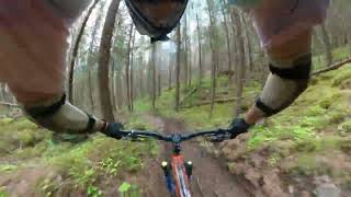
Stien starter med en kort travers før du slippes rett inn i det bratteste partiet – en håndbygd, sandfarget slange som snor seg ned fjellsiden. Etter dette treffer du en gammel traktorvei hvor farten øker og høyden forsvinner raskt. Resten av stien følger denne traseen med håndbygde svinger og hopp. Følg med på endringer Målet er å bygge stadig flere svinger, så det kan dukke opp nye der du minst venter det!

For å sykle denne stien, har du tre alternativer for tilkomst:
Sykle opp (eller shuttle deler av) grusveien som starter nord for sentrum / Alfarvegen.
Sykle opp grusveien fra Rukkedalen til starten av "Påskeekstra" og følg den til "Beaster".
Sykle fra toppen av Espeset, via stien "Påskeekstra".

English:
CLOSED BY LANDOWNER, PLEASE DO NOT USE
A trail inspired by the steep and tight turns of Tweed Valley in Scotland. Unlike Nesbyen’s fast and direct trails, this one features technical, steep corners mixed with high-speed sections.

"Beaster" = British Easter trail, a nod to trail builder Will Gibson and the neighboring "Påskestien".

The trail starts with a short traverse before dropping straight into the steepest section – a hand-built, sandy brown snake twisting down the mountainside. After this, you hit an old logging trail, gaining speed and dropping elevation fast. The rest of the trail follows this path with hand-built turns and jumps.

To ride this trail, there are three access options:
Cycle up (or shuttle part of) the gravel road that begins north of town / Alfarvegen.
Cycle up the gravel road from Rukkedalen to the start of "Påskeekstra" and follow it to "Beaster".
Cycle from the top of Espeset, via the trail "Påskeekstra".

Watch for changes! The goal is to add more corners over time, so expect new surprises!

Recent Activity on Trail

Past Week
  • 0 rides
  •  
6 Months
  • 0 rides
  •  
All
  • 25 rides
  • Last: Jun 5, 2026
c1c2c3c4
January
February
March
April
May
June
July
August
September
October
November
December
update trails status or condition

Beaster Trail Reports

statusdatedescription
Sep 12, 2025 @ 8:44pm (Europe/Oslo)
Sep 12, 2025
Wet but still good!
Aug 12, 2025 @ 8:23am
Aug 12, 2025
great work!
Jul 14, 2025 @ 10:54am
Jul 14, 2025
Tree in the middle of the track. Watch out when going fast
Jun 9, 2023 @ 8:38am
Jun 9, 2023
more »
Status:
on Sep 12, 2025
Wet
Avg: 4.21 (6 votes)
Your vote: 0

view (95)
close
3D
Trail Conditions
  • Unknown
  • Snow Groomed
  • Snow Packed
  • Snow Covered
  • Snow Cover Partial
  • Freeze/thaw Cycle
  • Icy
  • Prevalent Mud
  • Wet
  • Variable
  • Ideal
  • Dry
  • Very Dry
Trail Flow (Ridden Direction)
Trailforks scans users ridelogs to determine the most popular direction each trail is ridden. A good flowing trail network will have most trails flowing in a single direction according to their intension.
The colour categories are based on what percentage of riders are riding a trail in its intended direction.
  • > 96%
  • > 90%
  • > 80%
  • > 70%
  • > 50%
  • < 50%
  • bi-directional trail
  • no data
Trail Last Ridden
Trailforks scans ridelogs to determine the last time a trail was ridden.
  • < 2 days
  • < 1 week
  • < 2 weeks
  • < 1 month
  • < 6 months
  • > 6 months
Trail Ridden Direction
The intended direction a trail should be ridden.
  • Downhill Only
  • Downhill Primary
  • Both Directions
  • Uphill Primary
  • Uphill Only
  • One Direction
Contribute Details
Colors indicate trail is missing specified detail.
  • Description
  • Photos
  • Description & Photos
  • Videos
Trail Popularity ?
Trailforks scans ridelogs to determine which trails are ridden the most in the last 9 months. Trails are compared with nearby trails in the same city region with a possible 25 colour shades. Think of this as a heatmap, more rides = more kinetic energy = warmer colors.
  • most popular
  • popular
  • less popular
  • not popular
ATV/ORV/OHV Filter
Max Vehicle Width
inches
US Cell Coverage
Legend
cell carrier legend

Radar Time
Activity Recordings
Trailforks uses anonymized public activity data. ?
Activity Recordings
Trailforks uses anonymized public activity data. ?
Personal Heatmap
Activity Types
all / none
Options
2
Date range month
Winter Trails
Warning A routing network for winter maps does not exist. Selecting trails using the winter trails layer has been disabled.
Missing Trails
Most Popular
Least Popular
Trails are colored based on popularity. The more popular a trail is, the more red. Less popular trails trend towards green.
Jump Magnitude Heatmap
Heatmap of where riders jump on trails. Zoom in to see individual jumps, click circles to view jump details.
BC Backroad Status

Service Road Atlas is a free to use, community-driven service for viewing and creating reports on the numerous back-country service roads around B.C. and Alberta.

map legend
Slope Aspect
Direction the slope faces
Flat N NE E SE S SW W NW
Trails Deemphasized
Trails are shown in grey.
disable
Only show trails with no bike usage.
Enable
Suggested Layers
Based on selected activity type

    Save the current map location and zoom level as your default home location whenever this page is loaded.

    Save
        Directions to beaster trailhead (60.579520, 9.072780)

        Photos

        5 more »
        56 |
        Jul 12, 2025 @ 2:43pm
        Jul 12, 2025
        120 |
        Apr 14, 2023 @ 4:56am
        Apr 14, 2023
        118 |
        Apr 14, 2023 @ 4:56am
        Apr 14, 2023
        100 |
        Apr 14, 2023 @ 4:56am
        Apr 14, 2023

        Videos

        1 more »
        Beaster and bottom part of Påskestien
        2:42 | 238 | Apr 14, 2023 , Nesbyen

        Reviews / Comments

        No reviews yet, be the first to write a review or ask a question.
        Use trail reports to comment on trail conditions.


        We hope you've been enjoying Trailforks!

        Create a FREE account to view trail comments and much more.

        • By larsstorheimTF Pro H Rides & contributors
        • #626524 - 441 views

        Frequently Asked Questions About Beaster

        Where is Beaster located?
        Beaster is located in Nesbyen sentrum, Norway. It is part of the Nesbyen sentrum trail network. The trailhead is located at coordinates 60.57952, 9.07278.
        How hard is Beaster?
        Beaster is rated as Black difficulty. The average grade is 25.2%.
        What is the elevation gain for Beaster?
        Beaster has 8 ft of elevation gain. The trail has 977 ft of elevation descent. The elevation ranges from 961 ft to 1,930 ft.
        Is Beaster a point to point trail?
        Beaster is not a point to point trail. The direction is Downhill Primary. The trail type is singletrack.

        Hit the Trail

        Open in App

        Get this trail on your phone instantly.
        open trail in app

        Download Trail

        Save to wishlist, Garmin & download.
        save the trail

        Find Related Routes

        Find routes and users activities that include this trail.
        find routes for this trail

        You must enter a description before submitting.