more stats
1,601 ft
Distance
-287 ft
Descent
00:05:44
Avg time
-287 ft
Altitude change
2,330 ft
Altitude min
2,618 ft
Altitude max
2,616 ft
Altitude start
2,329 ft
Altitude end
-17.9%
Grade
-41.9%
Grade max
2.2%
Grade min
59 ft
Distance climb
1,542 ft
Distance down
00:05:44
Avg time

Beaver Pass Details

  • Activities
    • Mountain Bike
    • E-Bike
    • Hike
    • Trail Running
  • Riding Area
    Westside - Sproatt
    Whistler, British Columbia
  • Difficulty Rating
  • Local Popularity
    60 in Mountain Biking [+]
    • 40 in E-Biking
    • 20 in Trail Running
    • 30 in Hiking
  • Global Ranking
    #93583 in Mountain Biking [+]
    • #86247 in E-Biking
    • #128424 in Trail Running
    • #119376 in Hiking
  • Trail Type
    Singletrack
  • Bike Type
    AM, XC
  • Direction
    Downhill Primary
    Popular Direction Shown
  • Physical Rating
    Hard
  • Dogs Allowed
    Yes
  • eBike Allowed
    Yes up to Class 1

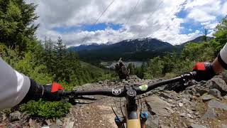
Beaver Pass is a trail that offers excellent views from a unique perspective of the valley. Unfortunately, ongoing construction at Stonebridge has made finding the trail head a bit of a challenge.

Access Info

The trail is accessed by riding up Stonebridge Drive for about 2km. Look for a very expensive trail marker about 200m past Scotia Creek (immediately opposite Stonebridge Place). Follow a new acces road along the power lines for about 1 km and pick a single-track trail that descends into a series of tight switchbacks.

Local Trail Association

Recent Activity on Trail

Past Week
  • 7 rides
  • 13 miles average
6 Months
  • 46 rides
  • 10 miles avg distance
All
  • 583 rides
  • Last: Jul 1, 2026
c1c2c3c4
January
February
March
April
May
June
July
August
September
October
November
December
Status:
on Jun 24, 2026
Dry
Avg: 3.78 (22 votes)
Your vote: 0

view (3,137)
close
3D
Trail Conditions
  • Unknown
  • Snow Groomed
  • Snow Packed
  • Snow Covered
  • Snow Cover Partial
  • Freeze/thaw Cycle
  • Icy
  • Prevalent Mud
  • Wet
  • Variable
  • Ideal
  • Dry
  • Very Dry
Trail Flow (Ridden Direction)
Trailforks scans users ridelogs to determine the most popular direction each trail is ridden. A good flowing trail network will have most trails flowing in a single direction according to their intension.
The colour categories are based on what percentage of riders are riding a trail in its intended direction.
  • > 96%
  • > 90%
  • > 80%
  • > 70%
  • > 50%
  • < 50%
  • bi-directional trail
  • no data
Trail Last Ridden
Trailforks scans ridelogs to determine the last time a trail was ridden.
  • < 2 days
  • < 1 week
  • < 2 weeks
  • < 1 month
  • < 6 months
  • > 6 months
Trail Ridden Direction
The intended direction a trail should be ridden.
  • Downhill Only
  • Downhill Primary
  • Both Directions
  • Uphill Primary
  • Uphill Only
  • One Direction
Contribute Details
Colors indicate trail is missing specified detail.
  • Description
  • Photos
  • Description & Photos
  • Videos
Trail Popularity ?
Trailforks scans ridelogs to determine which trails are ridden the most in the last 9 months. Trails are compared with nearby trails in the same city region with a possible 25 colour shades. Think of this as a heatmap, more rides = more kinetic energy = warmer colors.
  • most popular
  • popular
  • less popular
  • not popular
ATV/ORV/OHV Filter
Max Vehicle Width
inches
US Cell Coverage
Legend
cell carrier legend

Radar Time
Activity Recordings
Trailforks uses anonymized public activity data. ?
Activity Recordings
Trailforks uses anonymized public activity data. ?
Personal Heatmap
Activity Types
all / none
Options
2
Date range month
Winter Trails
Warning A routing network for winter maps does not exist. Selecting trails using the winter trails layer has been disabled.
Missing Trails
Most Popular
Least Popular
Trails are colored based on popularity. The more popular a trail is, the more red. Less popular trails trend towards green.
Jump Magnitude Heatmap
Heatmap of where riders jump on trails. Zoom in to see individual jumps, click circles to view jump details.
BC Backroad Status

Service Road Atlas is a free to use, community-driven service for viewing and creating reports on the numerous back-country service roads around B.C. and Alberta.

map legend
Slope Aspect
Direction the slope faces
Flat N NE E SE S SW W NW
Trails Deemphasized
Trails are shown in grey.
disable
Only show trails with no bike usage.
Enable
Suggested Layers
Based on selected activity type

    Save the current map location and zoom level as your default home location whenever this page is loaded.

    Save
        Directions to beaver-pass trailhead (50.118960, -122.991350)

        Photos

        37 more »
        28 |
        Apr 4, 2026 @ 6:29pm
        Apr 4, 2026
        115 |
        Aug 11, 2019 @ 5:53pm
        Aug 11, 2019
        240 |
        Jun 24, 2019 @ 1:55pm
        Jun 24, 2019
        117 |
        Jun 14, 2019 @ 2:06pm
        Jun 14, 2019

        Videos

        9 more »
        youtuber BEAVER PASS | Black trail | Whistler
        3:05 | 152 | Nov 27, 2023 , Whistler
        youtuber Bleeding Out Of What Hole ?!?
        9:41 | 160 | Apr 21, 2024 , Whistler
        Beaver Pass, Whistler, BC
        8:15 | 475 | May 1, 2021 , Whistler
        beaver pass to lower
        6:27 | 415 | Jun 30, 2020 , Whistler

        Trail Lists

        Routes with this trail

        4.2 13 miles 1,896 ft 41 Loop
        A Sample of Whistler's Westside is an advanced technical trail featuring several rockfaces, difficult...
        4 miles 861 ft 10 Point to Point
        Thursday, June 4, 2026 | Start: 6:30 PM Apres hosted by Scandinave Spa: 8 PM - 10 PM Course sponsorship:...
        4 miles 865 ft 7 Point to Point
        WORCA IRL Toonie July 25, 2024 Sponsored by Whistler Connection, Whistler Brewing, Mons Royale and...

        Trail Products

        2 Reviews & Comments


        We hope you've been enjoying Trailforks!

        Create a FREE account to view trail comments and much more.

        • By canadakaTF Pro Trailforks & contributors
        • #1668 - 10,059 views

        Frequently Asked Questions About Beaver Pass

        Where is Beaver Pass located?
        Beaver Pass is located in Westside - Sproatt, Whistler, British Columbia, Canada. It is part of the Westside - Sproatt trail network. The trailhead is located at coordinates 50.11896, -122.99135.
        How hard is Beaver Pass?
        Beaver Pass is rated as Black Diamond difficulty. The physical rating is Hard. The average grade is 17.9%.
        What is the elevation gain for Beaver Pass?
        The trail has 87 m of elevation descent. The elevation ranges from 710 m to 798 m.
        Is Beaver Pass a point to point trail?
        Beaver Pass is not a point to point trail. The direction is Downhill Primary. The trail type is singletrack.

        Hit the Trail

        Open in App

        Get this trail on your phone instantly.
        open trail in app

        Download Trail

        Save to wishlist, Garmin & download.
        save the trail

        Find Related Routes

        Find routes and users activities that include this trail.
        find routes for this trail

        You must enter a description before submitting.