more stats
2.1 miles
Distance
61 ft
Climb
-171 ft
Descent
00:20:52
Avg time
-110 ft
Altitude change
4,161 ft
Altitude min
4,290 ft
Altitude max
4,274 ft
Altitude start
4,163 ft
Altitude end
-1%
Grade
-21.9%
Grade max
10.8%
Grade min
2,989 ft
Distance climb
4,331 ft
Distance down
3,707 ft
Distance flat
00:20:52
Avg time

Big Park Loop Details

  • Activities
    • Mountain Bike
    • Adaptive Bike
    • Horse
    • Hike
    • Trail Running
  • Riding Area
    Big Park
    Village Of Oak Creek, Arizona
  • Difficulty Rating
  • Voted Difficulty
    Green (1 vote)
  • Local Popularity
    55 in Mountain Biking [+]
    • 45 in Trail Running
    • 55 in Hiking
    • 5 in Horseback
  • Global Ranking
    #8789 in Mountain Biking [+]
    • #92250 in Trail Running
    • #82505 in Hiking
  • Trail Type
    Singletrack
  • Bike Type
  • Direction
    Both Directions
  • Dogs Allowed
    Yes
  • eBike Allowed

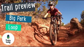
Beginner 70% and intermediate 30%, 2.5 mile MTB trail which is a bi-directional wide singletrack that doesn’t have much climbing but a lot of short ups and downs, it is twisty with several dry creek crossings, lots of small drops and some semi technical sections. The trail tread is mostly packed dirt mixed with rocks.

Adaptive Bike Info
aMTB Blue Rating: Intermediate features and steeper terrain.

Gets narrow towards the outer parts. Use Middle to bypass

Trail Supporters

  • USFS
    Land Manager
Local Trail Association

Recent Activity on Trail

Past Week
  • 3 rides
  • 8 miles average
6 Months
  • 82 rides
  • 14 miles avg distance
All
  • 837 rides
  • Last: Jun 27, 2026
c1c2c3c4
January
February
March
April
May
June
July
August
September
October
November
December
update trails status or condition

Big Park Loop Trail Reports

statusdatedescription
Feb 27, 2026 @ 10:30am (America/Phoenix)
Feb 27, 2026
Oct 10, 2025 @ 1:58pm (America/Phoenix)
Oct 10, 2025
Damp but only two or three short muddy spots when we rode the loop this morning but as rain started falling, it was changing to wet. Will need a...
Apr 9, 2025 @ 11:32pm
Apr 9, 2025
Hot today!
Jan 4, 2025 @ 1:29pm
Jan 4, 2025
Dec 10, 2024 @ 2:25pm
Dec 10, 2024
more »
Status:
on Feb 27, 2026
Ideal
Avg: 3.88 (20 votes)
Your vote: 0

view (3,367)
close
3D
Trail Conditions
  • Unknown
  • Snow Groomed
  • Snow Packed
  • Snow Covered
  • Snow Cover Partial
  • Freeze/thaw Cycle
  • Icy
  • Prevalent Mud
  • Wet
  • Variable
  • Ideal
  • Dry
  • Very Dry
Trail Flow (Ridden Direction)
Trailforks scans users ridelogs to determine the most popular direction each trail is ridden. A good flowing trail network will have most trails flowing in a single direction according to their intension.
The colour categories are based on what percentage of riders are riding a trail in its intended direction.
  • > 96%
  • > 90%
  • > 80%
  • > 70%
  • > 50%
  • < 50%
  • bi-directional trail
  • no data
Trail Last Ridden
Trailforks scans ridelogs to determine the last time a trail was ridden.
  • < 2 days
  • < 1 week
  • < 2 weeks
  • < 1 month
  • < 6 months
  • > 6 months
Trail Ridden Direction
The intended direction a trail should be ridden.
  • Downhill Only
  • Downhill Primary
  • Both Directions
  • Uphill Primary
  • Uphill Only
  • One Direction
Contribute Details
Colors indicate trail is missing specified detail.
  • Description
  • Photos
  • Description & Photos
  • Videos
Trail Popularity ?
Trailforks scans ridelogs to determine which trails are ridden the most in the last 9 months. Trails are compared with nearby trails in the same city region with a possible 25 colour shades. Think of this as a heatmap, more rides = more kinetic energy = warmer colors.
  • most popular
  • popular
  • less popular
  • not popular
ATV/ORV/OHV Filter
Max Vehicle Width
inches
US Cell Coverage
Legend
cell carrier legend

Radar Time
Activity Recordings
Trailforks uses anonymized public activity data. ?
Activity Recordings
Trailforks uses anonymized public activity data. ?
Personal Heatmap
Activity Types
all / none
Options
2
Date range month
Winter Trails
Warning A routing network for winter maps does not exist. Selecting trails using the winter trails layer has been disabled.
Missing Trails
Most Popular
Least Popular
Trails are colored based on popularity. The more popular a trail is, the more red. Less popular trails trend towards green.
Jump Magnitude Heatmap
Heatmap of where riders jump on trails. Zoom in to see individual jumps, click circles to view jump details.
BC Backroad Status

Service Road Atlas is a free to use, community-driven service for viewing and creating reports on the numerous back-country service roads around B.C. and Alberta.

map legend
Slope Aspect
Direction the slope faces
Flat N NE E SE S SW W NW
Trails Deemphasized
Trails are shown in grey.
disable
Only show trails with no bike usage.
Enable
Suggested Layers
Based on selected activity type

    Save the current map location and zoom level as your default home location whenever this page is loaded.

    Save
        Directions to big-park-loop trailhead (34.797690, -111.762990)

        Photos

        28 more »
        366 |
        Jan 8, 2017 @ 1:17pm
        Jan 8, 2017
        108 |
        May 8, 2024 @ 12:34pm
        May 8, 2024
        104 |
        May 6, 2024 @ 12:39pm
        May 6, 2024
        85 |
        Jan 28, 2024 @ 10:43am
        Jan 28, 2024

        Videos

        6 more »
        youtuber Trail Preview: Big Park Loop - Roam Bike Fest...
        8:02 | 1032 | Oct 22, 2019 , Village Of Oak Creek
        Big Park Loop
        7:31 | 428 | Feb 19, 2023 , Village Of Oak Creek
        MTB Riding Sedona | Bell Rock Vista Trails |...
        29:39 | 305 | Sep 10, 2022 , Village Of Oak Creek
        MTB Riding Day 1: DH Only Sedona, Apr 30, 2021
        6:59 | 253 | Nov 1, 2021 , Village Of Oak Creek

        Trail Lists

        Routes with this trail

        4.0 9 miles 696 ft 15
        This is a great beginner loop in Sedona. is super mellow and picturesque. is a bit more technical and...
        8 miles 840 ft 2
        old outer plus new and trails
        1.0 6 miles 460 ft 8 Loop
        This fast and fun lap is perfect for a quick ride whether you are a beginner or advanced rider. From the...

        9 Reviews & Comments


        We hope you've been enjoying Trailforks!

        Create a FREE account to view trail comments and much more.

        • By toddTF Pro Trailforks & contributors
        • #14690 - 8,502 views

        Frequently Asked Questions About Big Park Loop

        Where is Big Park Loop located?
        Big Park Loop is located in Big Park, Village Of Oak Creek, Arizona, United States. It is part of the Big Park trail network. The trailhead is located at coordinates 34.79769, -111.76299.
        How hard is Big Park Loop?
        Big Park Loop is rated as Green difficulty. The average grade is 1%.
        What is the elevation gain for Big Park Loop?
        Big Park Loop has 61 ft of elevation gain. The trail has 171 ft of elevation descent. The elevation ranges from 4,161 ft to 4,290 ft.
        Is Big Park Loop a point to point trail?
        Big Park Loop is not a point to point trail. The direction is Both Directions. The trail type is singletrack.

        Hit the Trail

        Open in App

        Get this trail on your phone instantly.
        open trail in app

        Download Trail

        Save to wishlist, Garmin & download.
        save the trail

        Find Related Routes

        Find routes and users activities that include this trail.
        find routes for this trail

        You must enter a description before submitting.