1.3 miles
Distance
-540 ft
Descent
00:07:49
Avg time

Billy T Details

  • Activities
    • Mountain Bike
    • E-Bike
  • Riding Area
  • Difficulty Rating
  • Trail Type
    Singletrack
  • Direction
    Downhill Only
    Popular direction shown
  • Dogs Allowed
    Yes
  • eBike Allowed
    Yes up to Class 1
  • TTFs on Trail
    Berm, Drop, Jump, Wallride
  • Global Ranking
    #579 in Mountain Biking [+]
    • #795 in E-Biking
  • Local Popularity
    85 in Mountain Biking [+]
    • 85 in E-Biking

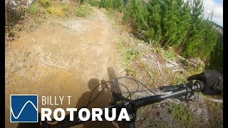
Starts from the top of Tawa end on Moerangi Rd. Sweet flowing downhill singletrack.
Downhill craziness that feels extreme but isn’t, if you can get up to it the Billy is the best. I can't believe riders are rating this as a 3 This trail is so sweet I could kiss it. It rides particularly well in the spring after the trail has dried a bit and before the summer sun bakes it to dust. There are so many lines you want to ride it again and again, plus it provides a great connection to Moerangi then to Loop Rd and Split Enz.
It's not super technical - give it a smack.

January 2020 - has been reopened after logging to be Billy T again.

The open areas of this trail can succumb to frost damage, so please avoid when frosty.

source: Ride Rotorua
Access Info

From the shuttle drop, continue up the hill for 200M

Local Trail Association
More Stats for Billy T mountain bike trail trail
  • Altitude change
    -541 ft
  • Altitude min
    1,846 ft
  • Altitude max
    2,387 ft
  • Altitude start
    2,387 ft
  • Altitude end
    1,847 ft
  • Grade
    -8.1%
  • Grade max
    -32.9%
  • Grade min
    1%
  • Distance climb
    33 ft
  • Distance down
    1 mile
  • Distance flat
    341 ft
  • Avg time
    00:07:49
  • Avg reverse time
    00:22:42
  • view trail stats
Status:
on Feb 16, 2023
Ideal
Avg: 4.6 (54 votes)
Your vote: 0

view (6,830)
close
3D
Trail Conditions
  • Unknown
  • Snow Groomed
  • Snow Packed
  • Snow Covered
  • Snow Cover Inadequate
  • Freeze/thaw Cycle
  • Icy
  • Prevalent Mud
  • Wet
  • Variable
  • Ideal
  • Dry
  • Very Dry
Trail Flow (Ridden Direction)
Trailforks scans users ridelogs to determine the most popular direction each trail is ridden. A good flowing trail network will have most trails flowing in a single direction according to their intension.
The colour categories are based on what percentage of riders are riding a trail in its intended direction.
  • > 96%
  • > 90%
  • > 80%
  • > 70%
  • > 50%
  • < 50%
  • bi-directional trail
  • no data
Trail Last Ridden
Trailforks scans ridelogs to determine the last time a trail was ridden.
  • < 2 days
  • < 1 week
  • < 2 weeks
  • < 1 month
  • < 6 months
  • > 6 months
Trail Ridden Direction
The intended direction a trail should be ridden.
  • Downhill Only
  • Downhill Primary
  • Both Directions
  • Uphill Primary
  • Uphill Only
  • One Direction
Contribute Details
Colors indicate trail is missing specified detail.
  • Description
  • Photos
  • Description & Photos
  • Videos
Trail Popularity ?
Trailforks scans ridelogs to determine which trails are ridden the most in the last 9 months. Trails are compared with nearby trails in the same city region with a possible 25 colour shades. Think of this as a heatmap, more rides = more kinetic energy = warmer colors.
  • most popular
  • popular
  • less popular
  • not popular
ATV/ORV/OHV Filter
Max Vehicle Width
inches

Radar Time
x Activity Recordings
Trailforks users anonymized public ridelogs from the past 6 months.
  • mountain biking recent
  • mountain biking (>6 month)
  • hiking (1 year)
  • moto (1 year)
Activity Recordings
Trailforks users anonymized public skilogs from the past 12 months.
  • Downhill Ski
  • Backcountry Ski
  • Nordic Ski
  • Snowmobile
Jump Magnitude Heatmap
Heatmap of where riders jump on trails. Zoom in to see individual jumps, click circles to view jump details.
Trails Deemphasized
Trails are shown in grey.
disable
Only show trails with NO bikes.
enable

Save the current map location and zoom level as your default home location whenever this page is loaded.

Save
      Directions to billy-t trailhead (-38.177670, 176.312590)
      update trails status or condition

      Billy T Trail Reports

      statusdatedescription
      Feb 16, 2023 @ 10:04pm
      Feb 16, 2023
      nice work by adoptee - trail is immaculate, thanks!
      Feb 16, 2023 @ 7:34pm
      Feb 16, 2023
      like everywhere loads of foliage debris, did a full rake groom on BillyT including UnderBilly cleared small twig across trail, ENJOY!!!
      Feb 13, 2023 @ 4:24pm
      Feb 13, 2023
      small tree down. easy and early to see
      Jan 28, 2023 @ 7:14pm
      Jan 28, 2023
      Drain all clear, was over the trail last year as well during heavy rain period and found quite easy to clear..
      Jan 28, 2023 @ 3:27pm
      Jan 28, 2023
      reporter Drais and ie need cleaeiing digger job whole Track uderwater
      view all reports »

      Recent Ridelog Activity on Trail

      Past Week
      • 22 rides
      • 23 miles avg distance
      6 Months
      • 623 rides
      • 27 miles avg distance
      All
      • 5,798 rides
      • Last: Mar 25, 2023

      Photos

      more »
      0 |
      Mar 7, 2023 @ 8:40pm
      Mar 7, 2023
      62 |
      Dec 23, 2021 @ 6:14pm
      Dec 23, 2021
      832 |
      Mar 26, 2017 @ 3:07am
      Mar 26, 2017
      | 2 comments
      710 |
      Dec 11, 2016 @ 1:15am
      Dec 11, 2016

      Trail Lists

      Trail Products

      Reviews / Comments

      No reviews yet, be the first to write a review or ask a question.
      Use trail reports to comment on trail conditions.


      Login or Sign Up to Comment

      Videos

      more »
      youtuber Billy T - Rotorua's Favourite track
      6:30 | 191 | Jun 8, 2021 , Rotorua
      youtuber ENDLESS LINES - Billy T Mountain Bike Trail...
      5:11 | 480 | Apr 24, 2021 , Rotorua
      youtuber Billy T trail  ●  Redwoods Forest, Rotorua...
      6:19 | 1032 | Feb 25, 2018 , Rotorua
      BILLY T Rotorua-Trail forks series
      9:17 | 46 | Nov 24, 2022 , Rotorua
      • subscribe
      • flag
      • login to download gpx or kml files.