more stats
6.2 miles
Distance
852 ft
Climb
-1,350 ft
Descent
01:58:00
Avg time
-498 ft
Altitude change
3,138 ft
Altitude min
4,178 ft
Altitude max
4,077 ft
Altitude start
3,579 ft
Altitude end
-1.5%
Grade
-35.2%
Grade max
38.9%
Grade min
2 miles
Distance climb
4 miles
Distance down
925 ft
Distance flat
01:58:00
Avg time

Bluff Mountain Details

  • Activities
    • Mountain Bike
    • Horse
    • Hike
    • Trail Running
  • Riding Area
    Silver Star Scenic Area
    North Bonneville, Washington
  • Ref Number
    #172
  • Difficulty Rating
  • Voted Difficulty
    Black Diamond (1 vote)
  • Local Popularity
    40 in Mountain Biking [+]
    • 40 in Trail Running
    • 5 in Hiking
    • 5 in Horseback
  • Global Ranking
    #112172 in Mountain Biking [+]
    • #115232 in Trail Running
    • #291617 in Hiking
    • #3437 in Horseback
  • Hiking SAC Scale
    T1 Hiking
  • Trail Type
    Singletrack
  • Bike Type
    AM, XC
  • Direction
    Both Directions
  • Climb Difficulty
    Black Diamond
  • Physical Rating
    Hard
  • Season
    Summer, Fall
  • Dogs Allowed
    Yes
  • eBike Allowed
  • Land Owner
    USFS, DNR

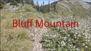
The Bluff Mountain trail is the eastern approach to the Silver Star mountain trail complex. The trail begins as an old road bed for the first 3 miles. The views are incredible from the get-go as you traverse a ridgetop and can peer down into canyons, valleys and glimpse Mt Hood towering in the distance. After about two miles you'll see Bluff Mountain become pronounced in front of you. At mile three, you'll be upon it as the trail starts to veer to the right (west) of it.

Continue on the trail another 2/3 mile as it keeps arcing to the right and heads due west. You'll see the distinctive Little Baldy Mountain right in front of you. You'll pass it to the left (the trail does not cross its summit) at just under the four mile mark. Little Baldy's top is mostly loose talus.Soon the trail narrows and climbs to the tops of a distinct spiny ridgeline, through rugged basaltic, volcanic outcrops. The trail will undulate, gaining and losing elevation. This area can be quite brushy as it receives very little maintenance.

Finally, at the 5 mile mark, you reach a junction with the Starway Trail where the seldom traveled Starway Trail meets. Snow in this area can last late into June. The trail ends at the Silver Star trail, where you can turn left and climb up to the dual summits of Silver Star mountain and take in the views of 5 volcanoes

Trail Supporters

  • USFS
    Land Manager
Local Trail Association
Traditionally Indigenous Territory

Recent Activity on Trail

Past Week
  • 0 rides
  •  
6 Months
  • 0 rides
  •  
All
  • 3 rides
  • Last: May 10, 2026
c1c2c3c4
January
February
March
April
May
June
July
August
September
October
November
December
update trails status or condition

Bluff Mountain Trail Reports

statusdatedescription
May 14, 2026 @ 8:15am (America/Los_Angeles)
May 14, 2026
Rode from the top of Silver Star on May 11, trail was running surprisingly well. A couple of spots had seen some pretty minor rock/mud slides that...
Sep 24, 2024 @ 4:35pm
Sep 24, 2024
Trail is clear and riding good. the Beargrass and huckleberry bushes are making the trail tight in spots
Sep 13, 2023 @ 8:31am
Sep 13, 2023
Report for 9/11. The trail base was prime. Quite a few overgrown areas before the exposed rock slope section making for scraped up shins. Still...
Jun 21, 2023 @ 12:29pm
Jun 21, 2023
Jun 21, 2023 @ 12:29pm
Jun 21, 2023
Snow field traverse at start and ends. Very over grown. I’d hold off riding till later in the season
more »
Status:
on May 14, 2026
Dry
Avg: 3.76 (3 votes)
Your vote: 0

view (25)
close
3D
Trail Conditions
  • Unknown
  • Snow Groomed
  • Snow Packed
  • Snow Covered
  • Snow Cover Partial
  • Freeze/thaw Cycle
  • Icy
  • Prevalent Mud
  • Wet
  • Variable
  • Ideal
  • Dry
  • Very Dry
Trail Flow (Ridden Direction)
Trailforks scans users ridelogs to determine the most popular direction each trail is ridden. A good flowing trail network will have most trails flowing in a single direction according to their intension.
The colour categories are based on what percentage of riders are riding a trail in its intended direction.
  • > 96%
  • > 90%
  • > 80%
  • > 70%
  • > 50%
  • < 50%
  • bi-directional trail
  • no data
Trail Last Ridden
Trailforks scans ridelogs to determine the last time a trail was ridden.
  • < 2 days
  • < 1 week
  • < 2 weeks
  • < 1 month
  • < 6 months
  • > 6 months
Trail Ridden Direction
The intended direction a trail should be ridden.
  • Downhill Only
  • Downhill Primary
  • Both Directions
  • Uphill Primary
  • Uphill Only
  • One Direction
Contribute Details
Colors indicate trail is missing specified detail.
  • Description
  • Photos
  • Description & Photos
  • Videos
Trail Popularity ?
Trailforks scans ridelogs to determine which trails are ridden the most in the last 9 months. Trails are compared with nearby trails in the same city region with a possible 25 colour shades. Think of this as a heatmap, more rides = more kinetic energy = warmer colors.
  • most popular
  • popular
  • less popular
  • not popular
ATV/ORV/OHV Filter
Max Vehicle Width
inches
US Cell Coverage
Legend
cell carrier legend

Radar Time
Activity Recordings
Trailforks uses anonymized public activity data. ?
Activity Recordings
Trailforks uses anonymized public activity data. ?
Personal Heatmap
Activity Types
all / none
Options
2
Date range month
Winter Trails
Warning A routing network for winter maps does not exist. Selecting trails using the winter trails layer has been disabled.
Missing Trails
Most Popular
Least Popular
Trails are colored based on popularity. The more popular a trail is, the more red. Less popular trails trend towards green.
Jump Magnitude Heatmap
Heatmap of where riders jump on trails. Zoom in to see individual jumps, click circles to view jump details.
BC Backroad Status

Service Road Atlas is a free to use, community-driven service for viewing and creating reports on the numerous back-country service roads around B.C. and Alberta.

map legend
Slope Aspect
Direction the slope faces
Flat N NE E SE S SW W NW
Trails Deemphasized
Trails are shown in grey.
disable
Only show trails with no bike usage.
Enable
Suggested Layers
Based on selected activity type

    Save the current map location and zoom level as your default home location whenever this page is loaded.

    Save
        Directions to bluff-mountain trailhead (45.749900, -122.242200)

        Photos

        30 more »
        38 |
        Sep 19, 2025 @ 1:07pm
        Sep 19, 2025
        115 |
        Sep 12, 2023 @ 10:16am
        Sep 12, 2023
        116 |
        Sep 12, 2023 @ 10:15am
        Sep 12, 2023
        194 |
        Jun 18, 2019 @ 3:15pm
        Jun 18, 2019

        Videos

        1 more »
        youtuber VOTR Bluff Mountain to 173 Loop
        10:18 | 793 | Jun 18, 2019 , North Bonneville

        Reviews / Comments

        No reviews yet, be the first to write a review or ask a question.
        Use trail reports to comment on trail conditions.


        We hope you've been enjoying Trailforks!

        Create a FREE account to view trail comments and much more.

        • By northwestdhdad EMBA-SW & contributors
        • #3336 - 4,689 views

        Frequently Asked Questions About Bluff Mountain

        Where is Bluff Mountain located?
        Bluff Mountain is located in Silver Star Scenic Area, North Bonneville, Washington, United States. It is part of the Silver Star Scenic Area trail network. The trailhead is located at coordinates 45.7499, -122.2422.
        How hard is Bluff Mountain?
        Bluff Mountain is rated as Black Diamond difficulty. The physical rating is Hard. The average grade is 1.5%. The climb difficulty is rated Black Diamond.
        What is the elevation gain for Bluff Mountain?
        Bluff Mountain has 852 ft of elevation gain. The trail has 1,350 ft of elevation descent. The elevation ranges from 3,138 ft to 4,178 ft.
        Is Bluff Mountain a point to point trail?
        Bluff Mountain is not a point to point trail. The direction is Both Directions. The trail type is singletrack.

        Hit the Trail

        Open in App

        Get this trail on your phone instantly.
        open trail in app

        Download Trail

        Save to wishlist, Garmin & download.
        save the trail

        Find Related Routes

        Find routes and users activities that include this trail.
        find routes for this trail

        You must enter a description before submitting.