more stats
3,481 ft
Distance
62 ft
Climb
-58 ft
Descent
00:07:08
Avg time
4 ft
Altitude change
268 ft
Altitude min
325 ft
Altitude max
321 ft
Altitude start
325 ft
Altitude end
0.1%
Grade
-19.5%
Grade max
9.8%
Grade min
1,440 ft
Distance climb
1,453 ft
Distance down
525 ft
Distance flat
00:07:08
Avg time

Bobsled Details

  • Activities
    • Mountain Bike
    • E-Bike
    • Horse
    • Hike
    • Trail Running
  • Riding Area
    Port Gamble Forest Heritage Park
    Port Gamble, Washington
  • Difficulty Rating
  • Local Popularity
    50 in Mountain Biking heatmap [+]
    • 45 in E-Biking
    • 45 in Trail Running
    • 65 in Hiking
    • 5 in Horseback
  • Global Ranking
    #119967 in Mountain Biking [+]
    • #131013 in E-Biking
    • #155258 in Trail Running
    • #139838 in Hiking
    • #22570 in Horseback
  • State Ranking
    #2,037 in Mountain Biking · Washington [+]
    • #1,618 in E-Biking
    • #4,671 in Trail Running
    • #4,695 in Hiking
    • #654 in Horseback
  • Trail Type
    Singletrack
  • Bike Type
    AM, XC
  • Direction
    Both Directions
  • Climb Difficulty
    Blue
  • Physical Rating
    Moderate
  • Dogs Allowed
    Yes
  • eBike Allowed
    Yes up to Class 1
  • TTFs on Trail
    Berm

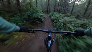
Connector trail to Derailed. Some berms, with good flow in sections. Rides well either direction.

Tags
BermsFlowy

Local Trail Association

Traditionally Indigenous Territory

Recent Activity on Trail

Past Week
  • 0 rides
  •  
6 Months
  • 67 rides
  • 22.0 km avg distance
All
  • 1,146 rides
  • Last: Nov 14, 2026
c1c2c3c4
January
February
March
April
May
June
July
August
September
October
November
December
update trails status or condition

Bobsled Trail Reports

statusdatedescription
Aug 26, 2026 @ 3:55pm (America/Vancouver)
Aug 26, 2026
Jun 6, 2026 @ 4:31pm (America/Los_Angeles)
Jun 6, 2026
Feb 20, 2026 @ 3:19pm (America/Los_Angeles)
Feb 20, 2026
There is extensive logging road construction branching off from this access road at multiple locations. It looks like Rayonier is going to do...
Jan 20, 2026 @ 7:49pm (America/Los_Angeles)
Jan 20, 2026
Tree down
Oct 10, 2025 @ 11:50am (America/Los_Angeles)
Oct 10, 2025
more »
Status:
on Aug 26, 2026
Ideal
Avg: 3.86 (9 votes)
Your vote: 0

view (5,213)
close
      Directions to bobsled-69220 trailhead (47.800890, -122.595170)

      Photos

      6 more »
      mtb
      634 |
      Nov 11, 2011 @ 11:00pm
      Nov 11, 2011
      mtb
      876 |
      Nov 11, 2011 @ 11:10pm
      Nov 11, 2011
      report
      mtb
      66 |
      Jun 6, 2026 @ 4:31pm
      Jun 6, 2026
      report
      mtb
      87 |
      Jan 20, 2026 @ 7:49pm
      Jan 20, 2026

      Videos

      1 more »
      Camelbak to Bobsled - Uncut - Port Gamble...
      mtb
      4:15 | 815 | Nov 19, 2020 , Port Gamble

      Routes with this trail

      more »
      ★ 5.0 • 18 miles • 1,881 ft • 20 • Loop •
      Looking to hit ALL the new downhills at Port Gamble in one ride? This route includes Derailed, The (new)...
      ★ 4.0 • 29 miles • 2,727 ft • 38 •
      NW Epic race series 2021 stottlemeyer
      7 miles • 659 ft • 10 • Loop • Race •
      This is the 2019 Budu race course starting at Stottlemeyer road.
      3.8 ★★★★★
      9 Ratings
      5 ★ 11%
      4 ★ 56%
      3 ★ 33%
      2 ★
      1 ★

      1 Review & Comments

      Combinednathan
      With a name like bobsled, you’d think the trail would be fun…

      We hope you've been enjoying Trailforks!

      Create a FREE account to view all trail reviews and much more.

      Frequently Asked Questions

      ▼ Where is Bobsled located?
      Bobsled is located in Port Gamble Forest Heritage Park, Port Gamble, Washington, United States. It is part of the Port Gamble Forest Heritage Park trail network. The trailhead is located at coordinates 47.80089, -122.59517.
      ▼ How hard is Bobsled?
      Bobsled is rated as Blue difficulty. The physical rating is Moderate. The average grade is 0.1%. The climb difficulty is rated Blue.
      ▼ What is the elevation gain for Bobsled?
      Bobsled has 62 ft of elevation gain. The trail has 58 ft of elevation descent. The elevation ranges from 268 ft to 325 ft.
      ▼ Is Bobsled a point to point trail?
      Bobsled is not a point to point trail. The direction is Both Directions. The trail type is singletrack.
      ▼ How long is Bobsled?
      Bobsled is 3,481 ft long. The trail type is singletrack.
      ▼ Are dogs allowed on Bobsled?
      Yes, dogs are allowed on Bobsled. Please keep dogs on a leash where required and clean up after them.
      ▼ How do I access Bobsled? Where is the closest parking trailhead?
      The closest parking and trailhead locations to Bobsled are: View all parking locations in the area.
      ▼ How long does it take to ride Bobsled?
      Based on recorded activities, it takes an average of 7 minutes to ride Bobsled. The trail is 3,481 ft long. Actual times will vary based on fitness level, conditions, and pace. View recent activity logs for more details.
      ▼ How busy is Bobsled?
      Bobsled is a moderately popular trail. There have been 4,680 recorded activities on this trail. The trail has received 5,213 check-ins. View recent activity on this trail.

      Hit the Trail

      Open in App

      Get this trail on your phone instantly.

      open trail in app

      Download Trail

      Save to wishlist, Garmin & download.
      save the trail

      Find Related Routes

      Find routes and users activities that include this trail.
      find routes for this trail

      You must enter a description before submitting.