Bobsled Loop Details
-
Activities
- Mountain Bike
- E-Bike
- Hike
- Trail Running
-
Riding AreaCuyuna Country State Recreation Area
Crosby, Minnesota -
Difficulty Rating
-
Trail TypeSingletrack
-
Bike TypeAM, XC, Fat
-
DirectionOne Direction
-
Climb DifficultyBlue
-
Physical RatingModerate
-
Dogs AllowedYes
-
eBike AllowedYes up to Class 1
-
TTFs on TrailBerm, Rock Garden
-
Global Ranking
-
Local Popularity100 in Mountain Biking [+]
- 95 in E-Biking
- 65 in Trail Running
- 95 in Hiking
-
Land Owner
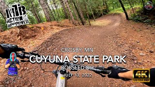
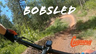
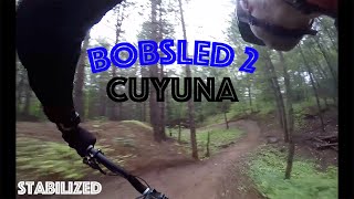
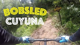
Easily one of the most fun and popular trails in Cuyuna The east trails around Yawkey Mine are basically a bike park. All of them are less than 2kms long and everything funnels back to your vehicle. Bobsled has the standard leg burning "pay the admission" then 7-8 massive 10' high x 20' wide hillside berms that line a small valley that funnels you back towards the start. Very well groomed, well maintained, and if you get really high on the walls your speed can get quite high. There's a shortcut option that allows you to forego the shale rock gardens that complete the circuit at the top of the trail. That being said, many less-experienced riders take the short cut and can mess up your flow if you're not aware while you're tearing around the berms!
Local Trail Association
-
Please consider joining or donating to the local trail association to supportdonate to earn trail karma!
trail development & maintenance.
Traditionally Indigenous Territory
More Stats for Bobsled Loop mountain bike trail trail
-
Altitude change-5 ft
-
Altitude min1,260 ft
-
Altitude max1,350 ft
-
Altitude start1,265 ft
-
Altitude end1,260 ft
-
Grade-0.1%
-
Grade max-14.6%
-
Grade min13.4%
-
Distance climb1,962 ft
-
Distance down2,172 ft
-
Distance flat1,670 ft
-
Avg time00:11:42
-
Avg reverse time00:14:49
- view trail stats
- Unknown
- Snow Groomed
- Snow Packed
- Snow Covered
- Snow Cover Partial
- Freeze/thaw Cycle
- Icy
- Prevalent Mud
- Wet
- Variable
- Ideal
- Dry
- Very Dry
The colour categories are based on what percentage of riders are riding a trail in its intended direction.
- > 96%
- > 90%
- > 80%
- > 70%
- > 50%
- < 50%
- bi-directional trail
- no data
- < 2 days
- < 1 week
- < 2 weeks
- < 1 month
- < 6 months
- > 6 months
- Downhill Only
- Downhill Primary
- Both Directions
- Uphill Primary
- Uphill Only
- One Direction
- Description
- Photos
- Description & Photos
- Videos
- most popular
- popular
- less popular
- not popular
- mountain biking recent
- mountain biking (>6 month)
- hiking (1 year)
- moto (1 year)
- Downhill Ski
- Backcountry Ski
- Nordic Ski
- Snowmobile
Save the current map location and zoom level as your default home location whenever this page is loaded.
SaveBobsled Loop Trail Reports
Recent Ridelog Activity on Trail
- 17 rides
- 12 miles avg distance
- 133 rides
- 14 miles avg distance
- 1,529 rides
- Last: Jun 17, 2025
Photos
Trail Lists
-
CCSRA - Yawkey Unit
17 trails
Routes with this trail
6 Reviews & Comments
We hope you've been enjoying Trailforks!
Create a FREE account to view trail comments and much more.
Videos

Nearby Trails
- Little Rock 259 ft
- Haul Road - Exit 397 ft
- Trout 423 ft
- Timber Shaft - T1 1,043 ft
- Manuel Drive 1,056 ft
Cuyuna Country State Recreation Area
- By brenthillier
NSMBA TRAILFORKS & contributors
- #4193 - 8,091 views
- follow/subscribe
- login to download gpx or kml files.
You must enter a description before submitting.