more stats
2.0 miles
Distance
3 ft
Climb
-986 ft
Descent
00:25:13
Avg time
-983 ft
Altitude change
3,682 ft
Altitude min
4,666 ft
Altitude max
4,666 ft
Altitude start
3,684 ft
Altitude end
-9.2%
Grade
-55.6%
Grade max
4.4%
Grade min
577 ft
Distance climb
2 miles
Distance down
623 ft
Distance flat
00:25:13
Avg time

Bone Shaker Details

  • Activities
    • Mountain Bike
    • Hike
    • Trail Running
  • Riding Area
    Red Rock - Cowboy Trails
    Las Vegas, Nevada
  • Difficulty Rating
  • Voted Difficulty
    Double Black Diamond (5 votes)
  • Local Popularity
    75 in Mountain Biking [+]
    • 90 in Trail Running
    • 90 in Hiking
  • Global Ranking
    #13412 in Mountain Biking [+]
    • #223 in Trail Running
    • #1238 in Hiking
  • Trail Type
    Singletrack
  • Bike Type
    DH, AM
  • Direction
    Downhill Primary
    Popular Direction Shown
  • Physical Rating
    Moderate
  • Season
    All Year
  • Dogs Allowed
    Yes
  • TTFs on Trail
    Drop
  • Ride in Rain
    Yes

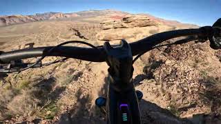
One of the more advanced trails in the area. Be ready for multiple 3-4 ft drops and lots of fast chunky rock. Trail starts off fast and flowy and then gets steep and tight. Most drops have a go around.

Access Info

Fastest way to the start is to take Bunny to Fossil to the top. Take the 2 track to the left and follow up to Scar. Go left and it will run into Boneshaker.

Trail Supporters
  • BLM
    BLM
    Land Manager
Local Trail Association

Recent Activity on Trail

Past Week
  • 0 rides
  •  
6 Months
  • 25 rides
  • 10 miles avg distance
All
  • 236 rides
  • Last: Jun 26, 2026
c1c2c3c4
January
February
March
April
May
June
July
August
September
October
November
December
update trails status or condition

Bone Shaker Trail Reports

Status:
on May 25, 2026
Dry
Avg: 4.56 (44 votes)
Your vote: 0

view (1,333)
close
3D
Trail Conditions
  • Unknown
  • Snow Groomed
  • Snow Packed
  • Snow Covered
  • Snow Cover Partial
  • Freeze/thaw Cycle
  • Icy
  • Prevalent Mud
  • Wet
  • Variable
  • Ideal
  • Dry
  • Very Dry
Trail Flow (Ridden Direction)
Trailforks scans users ridelogs to determine the most popular direction each trail is ridden. A good flowing trail network will have most trails flowing in a single direction according to their intension.
The colour categories are based on what percentage of riders are riding a trail in its intended direction.
  • > 96%
  • > 90%
  • > 80%
  • > 70%
  • > 50%
  • < 50%
  • bi-directional trail
  • no data
Trail Last Ridden
Trailforks scans ridelogs to determine the last time a trail was ridden.
  • < 2 days
  • < 1 week
  • < 2 weeks
  • < 1 month
  • < 6 months
  • > 6 months
Trail Ridden Direction
The intended direction a trail should be ridden.
  • Downhill Only
  • Downhill Primary
  • Both Directions
  • Uphill Primary
  • Uphill Only
  • One Direction
Contribute Details
Colors indicate trail is missing specified detail.
  • Description
  • Photos
  • Description & Photos
  • Videos
Trail Popularity ?
Trailforks scans ridelogs to determine which trails are ridden the most in the last 9 months. Trails are compared with nearby trails in the same city region with a possible 25 colour shades. Think of this as a heatmap, more rides = more kinetic energy = warmer colors.
  • most popular
  • popular
  • less popular
  • not popular
ATV/ORV/OHV Filter
Max Vehicle Width
inches
US Cell Coverage
Legend
cell carrier legend

Radar Time
Activity Recordings
Trailforks uses anonymized public activity data. ?
Activity Recordings
Trailforks uses anonymized public activity data. ?
Personal Heatmap
Activity Types
all / none
Options
2
Date range month
Winter Trails
Warning A routing network for winter maps does not exist. Selecting trails using the winter trails layer has been disabled.
Missing Trails
Most Popular
Least Popular
Trails are colored based on popularity. The more popular a trail is, the more red. Less popular trails trend towards green.
Jump Magnitude Heatmap
Heatmap of where riders jump on trails. Zoom in to see individual jumps, click circles to view jump details.
BC Backroad Status

Service Road Atlas is a free to use, community-driven service for viewing and creating reports on the numerous back-country service roads around B.C. and Alberta.

map legend
Slope Aspect
Direction the slope faces
Flat N NE E SE S SW W NW
Trails Deemphasized
Trails are shown in grey.
disable
Only show trails with no bike usage.
Enable
Suggested Layers
Based on selected activity type

    Save the current map location and zoom level as your default home location whenever this page is loaded.

    Save
        Directions to bone-shaker trailhead (36.107790, -115.409690)

        Photos

        28 more »
        54 |
        Jan 30, 2026 @ 6:31am
        Jan 30, 2026
        59 |
        Dec 6, 2025 @ 1:58pm
        Dec 6, 2025
        55 |
        Dec 6, 2025 @ 1:58pm
        Dec 6, 2025
        296 |
        Oct 27, 2022 @ 4:57pm
        Oct 27, 2022

        Videos

        25 more »
        youtuber Best expert mountain bike trail in Las Vegas,...
        13:13 | 364 | May 9, 2025 , Las Vegas
        youtuber How I have fun in Las Vegas! | Bomb Voyage...
        39:04 | 49 | Jan 30, 2026 , Las Vegas
        A ride down Bone Shaker, a super chunky double...
        6:37 | 89 | Dec 17, 2025 , Las Vegas
        MTB Spot Check: Las Vegas - Top Trails
        0:47 | 56 | May 18, 2025 , Las Vegas

        Routes with this trail

        4.3 32 miles 3,201 ft 21
        blue diamond to blue diamond around the cowboy
        5.0 9 miles 1,357 ft 14
        Good loop to test your tech-climbing ability. Grab a water break at the before heading back down.
        4.0 14 miles 2,049 ft 14 Loop
        Introduction to fun at the Cowboy Trails

        29 Reviews & Comments


        We hope you've been enjoying Trailforks!

        Create a FREE account to view trail comments and much more.

        • By toddTF Pro Trailforks & contributors
        • #15845 - 11,114 views

        Frequently Asked Questions About Bone Shaker

        Where is Bone Shaker located?
        Bone Shaker is located in Red Rock - Cowboy Trails, Las Vegas, Nevada, United States. It is part of the Red Rock - Cowboy Trails trail network. The trailhead is located at coordinates 36.10779, -115.40969.
        How hard is Bone Shaker?
        Bone Shaker is rated as Double Black Diamond difficulty. The physical rating is Moderate. The average grade is 9.2%.
        What is the elevation gain for Bone Shaker?
        Bone Shaker has 3 ft of elevation gain. The trail has 986 ft of elevation descent. The elevation ranges from 3,682 ft to 4,666 ft.
        Is Bone Shaker a point to point trail?
        Bone Shaker is not a point to point trail. The direction is Downhill Primary. The trail type is singletrack.

        Hit the Trail

        Open in App

        Get this trail on your phone instantly.
        open trail in app

        Download Trail

        Save to wishlist, Garmin & download.
        save the trail

        Find Related Routes

        Find routes and users activities that include this trail.
        find routes for this trail

        You must enter a description before submitting.