4,291 ft
Distance
-529 ft
Descent
00:09:07
Avg time
Supporters, Builders, Maintainers & Land Managers of Botanical Trail

  • USFS
    Land Manager

Botanical Details

  • Activities
    • Mountain Bike
    • E-Bike
    • Hike
    • Trail Running
  • Riding Area
    Cuesta Ridge West
    San Luis Obispo, California
  • Difficulty Rating
  • Voted Difficulty
    Black Diamond (3 votes)
  • Trail Type
    Singletrack
  • Bike Type
    AM, XC
  • Direction
    Downhill Primary
    Popular direction shown
  • Climb Difficulty
    Black Diamond
  • Dogs Allowed
    Yes
  • eBike Allowed
    Yes up to Class 1
  • TTFs on Trail
    Berm, Drop, Jump, Gap Jump, Rock Face, Rock Garden, Other
  • Global Ranking
    #12573 in Mountain Biking [+]
    • #75492 in Trail Running
    • #82238 in Hiking
  • Local Popularity
    90 in Mountain Biking [+]
    • 85 in E-Biking
    • 50 in Trail Running
    • 45 in Hiking

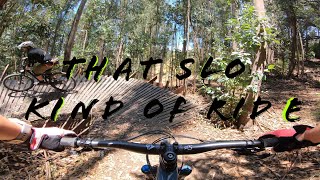
Chunky, loose, and fast, Botanical is a classic San Luis Obispo trail. Upper half (before intersection with Morning Glory) is covered with small pebbles, baby-head sized rocks, and rain ruts, however, it's pretty easy to get going really fast, just make sure you have some tough tires Difficulty is in between a blue and a black, definitely harder than other blue trails in the area.

This trail is unsanctioned.

Traditionally Indigenous Territory
More Stats for Botanical mountain bike trail trail
  • Altitude change
    -529 ft
  • Altitude min
    1,877 ft
  • Altitude max
    2,406 ft
  • Altitude start
    2,406 ft
  • Altitude end
    1,877 ft
  • Grade
    -12.3%
  • Grade max
    -42.6%
  • Grade min
    -1.6%
  • Distance down
    4,058 ft
  • Distance flat
    236 ft
  • Avg time
    00:09:07
  • Avg reverse time
    00:22:09
  • view trail stats
Status:
on Mar 8, 2025
Ideal
Avg: 4.05 (13 votes)
Your vote: 0

view (3,259)
close
3D
Trail Conditions
  • Unknown
  • Snow Groomed
  • Snow Packed
  • Snow Covered
  • Snow Cover Partial
  • Freeze/thaw Cycle
  • Icy
  • Prevalent Mud
  • Wet
  • Variable
  • Ideal
  • Dry
  • Very Dry
Trail Flow (Ridden Direction)
Trailforks scans users ridelogs to determine the most popular direction each trail is ridden. A good flowing trail network will have most trails flowing in a single direction according to their intension.
The colour categories are based on what percentage of riders are riding a trail in its intended direction.
  • > 96%
  • > 90%
  • > 80%
  • > 70%
  • > 50%
  • < 50%
  • bi-directional trail
  • no data
Trail Last Ridden
Trailforks scans ridelogs to determine the last time a trail was ridden.
  • < 2 days
  • < 1 week
  • < 2 weeks
  • < 1 month
  • < 6 months
  • > 6 months
Trail Ridden Direction
The intended direction a trail should be ridden.
  • Downhill Only
  • Downhill Primary
  • Both Directions
  • Uphill Primary
  • Uphill Only
  • One Direction
Contribute Details
Colors indicate trail is missing specified detail.
  • Description
  • Photos
  • Description & Photos
  • Videos
Trail Popularity ?
Trailforks scans ridelogs to determine which trails are ridden the most in the last 9 months. Trails are compared with nearby trails in the same city region with a possible 25 colour shades. Think of this as a heatmap, more rides = more kinetic energy = warmer colors.
  • most popular
  • popular
  • less popular
  • not popular
ATV/ORV/OHV Filter
Max Vehicle Width
inches
US Cell Coverage
Legend
cell carrier legend

Radar Time
x Activity Recordings
Trailforks users anonymized public ridelogs from the past 6 months.
  • mountain biking recent
  • mountain biking (>6 month)
  • hiking (1 year)
  • moto (1 year)
Activity Recordings
Trailforks users anonymized public skilogs from the past 12 months.
  • Downhill Ski
  • Backcountry Ski
  • Nordic Ski
  • Snowmobile
Winter Trails
Warning A routing network for winter maps does not exist. Selecting trails using the winter trails layer has been disabled.
x Missing Trails
Most Popular
Least Popular
Trails are colored based on popularity. The more popular a trail is, the more red. Less popular trails trend towards green.
Jump Magnitude Heatmap
Heatmap of where riders jump on trails. Zoom in to see individual jumps, click circles to view jump details.
Trails Deemphasized
Trails are shown in grey.
disable
Only show trails with NO bikes.
enable

Save the current map location and zoom level as your default home location whenever this page is loaded.

Save
      Directions to botanical trailhead (35.361820, -120.657870)
      update trails status or condition

      Botanical Trail Reports

      Recent Ridelog Activity on Trail

      Past Week
      • 1 rides
      • 10 miles avg distance
      6 Months
      • 17 rides
      • 15 miles avg distance
      All
      • 281 rides
      • Last: Mar 23, 2025

      Photos

      more »
      54 |
      Nov 7, 2020 @ 6:43pm
      Nov 7, 2020
      65 |
      Feb 20, 2020 @ 3:17pm
      Feb 20, 2020
      111 |
      Feb 20, 2020 @ 3:17pm
      Feb 20, 2020
      75 |
      Oct 15, 2019 @ 9:48am
      Oct 15, 2019

      Routes with this trail

      more »
      titledistance
      Ultimate Ridge Shuttle Route27 miles
      Cuesta DH6 miles
      Best of West Cuesta Ridge (Intermediate Route)12 miles
      Cuesta Loop8 miles

      Links

      1 Review & Comments


      We hope you've been enjoying Trailforks!

      Create a FREE account to view trail comments and much more.

      Videos

      more »
      youtuber Botanical Trail - San Luis Obispo, CA
      3:23 | 394 | May 24, 2020 , San Luis Obispo
      Quest For Fun on Cuesta Ridge & The Eucs |...
      30:06 | 44 | Mar 18, 2024 , San Luis Obispo
      Mountain Biking Botanicals & Morning Glory...
      15:52 | 97 | Apr 26, 2023 , San Luis Obispo
      youtuber Hidden Gem in San Luis Obispo | West Cuesta...
      14:56 | 193 | Apr 9, 2021 , San Luis Obispo
      • #28366 - 3,577 views

      You must enter a description before submitting.