
6.5 miles
Distance
252 ft
Climb
-2,279 ft
Descent
2,403 ft
High Point
-2,028 ft
Altitude change
369 ft
Altitude min
2,403 ft
Altitude start
374 ft
Altitude end
-6%
Grade
-52%
Grade max
21.5%
Grade min
1 mile
Distance climb
5 miles
Distance down
3,442 ft
Distance flat

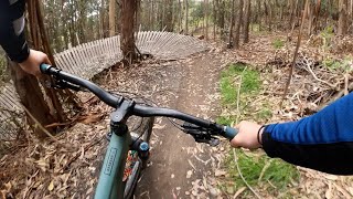
A mostly DH shuttled ride from the top of Cuesta Ridge down to CalPoly.

Detailed Description
Cuesta DH is a 6 mile popular intermediate route located near Cuesta Ridge West California. This mountain bike only route can be used one direction and has a moderate overall physical rating. This route includes 6 trails. This route climbs 252 ft with a max elevation of 2,403 ft then descends -2,279 ft.
Tags
BermsRidgelineShuttle access

Trail Issues on Route

  • Minor Issue / Yellow: 4 trails (newest: Nov 12, 2026)

Local Trail Association

Please consider joining or donating to the local riding association to support trail development & maintenance.
Donate to earn trail karma!

Stats

  • Distance
    6 miles
  • Avg time
    1 hr 8 min
  • Altitude change
    -2,028 ft
  • Altitude min
    369 ft
  • Altitude start
    2,403 ft
  • Altitude end
    374 ft
  • Climb
    252 ft
  • Descent
    -2,279 ft
  • Grade
    -6%
  • Grade max
    -52%
  • Grade min
    21.5%
  • Distance climb
    1 mile
  • Distance down
    5 miles
  • Distance flat
    3,442 ft

11 Reviews & Comments


We hope you've been enjoying Trailforks!

Create a FREE account to view all route reviews and much more.

Trails in Route

Details

  • Riding area
  • Primary Activity
    Mountain Bike
  • Difficulty rating
    Blue
  • Route Type
    Shuttled
  • Bike type
    DH
  • Direction
    One Direction
  • Physical rating
    Moderate
  • Activity Logs
    1
Avg: 4 (1 votes)
close
Trail transparency
  • Singletrack
  • Unpaved
......
mtb
......
0:11 | 827 | comments: 14 | favs: 6
Nov 29, 2008
mylfon...obłuze city...rozdziewiczanie ns troszke przeleciałem xD
Quest For Fun on Cuesta Ridge & The Eucs |...
mtb

Recent Trail Reports Along Route

statustraildateconditiondescription
Shooters
Nov 12, 2026 @ 10:07am (America/Los_Angeles)
2 days
Getting very rocky since the heavy rains keep washing away the dirt.
Poly Canyon Road
Aug 23, 2026 @ 9:06am (America/Los_Angeles)
Aug 23, 2026
Much smoother compared to the end of winter
Tough and Dirty Slide
Mar 7, 2026 @ 9:29am (America/Los_Angeles)
Mar 7, 2026
A few very minor rough cow track parts. Mostly good and completely dry. A good alternative down to avoid the mud still on Quercus.
Morning Glory
Jan 2, 2026 @ 11:03am (America/Los_Angeles)
Jan 2, 2026
Botanical
Jan 2, 2026 @ 11:03am (America/Los_Angeles)
Jan 2, 2026
more reports »
  • By aoneal & contributors
  • #387 - 2,551 views

Hit the Trail

Open in App

Get this route on your phone instantly.

Download Route

Save to wishlist, Garmin & download.