more stats
3,622 ft
Distance
24 ft
Climb
-161 ft
Descent
00:10:32
Avg time
-137 ft
Altitude change
592 ft
Altitude min
745 ft
Altitude max
729 ft
Altitude start
591 ft
Altitude end
-3.8%
Grade
-19.4%
Grade max
8.4%
Grade min
495 ft
Distance climb
2,264 ft
Distance down
863 ft
Distance flat
00:10:32
Avg time

Bottlerocket Details

  • Activities
    • Mountain Bike
    • E-Bike
    • Hike
    • Trail Running
  • Riding Area
    The Abyss / Extension Ridge
    Nanaimo, British Columbia
  • Difficulty Rating
  • Local Popularity
    60 in Mountain Biking [+]
    • 70 in E-Biking
    • 60 in Trail Running
    • 75 in Hiking
  • Global Ranking
    #102295 in Mountain Biking [+]
    • #58292 in E-Biking
    • #112791 in Trail Running
    • #64319 in Hiking
  • Trail Type
    Singletrack
  • Bike Type
    AM, XC
  • Direction
    Both Directions
  • Climb Difficulty
    Blue
  • Physical Rating
    Moderate
  • Trail Visibility
    Always easy to follow
  • Dogs Allowed
    Yes
  • eBike Allowed
    Yes up to Class 1

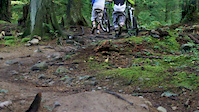
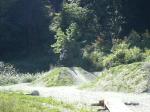
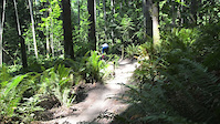
Bottle Rocket is a great trail that goes between Humble Ninja and the first lookout at the 7th street end of the Abyss. It offers a great climb up and a fast flowy down as you meander through different forest types.

This trail is unsanctioned.

Traditionally Indigenous Territory

Recent Activity on Trail

Past Week
  • 2 rides
  • 8 miles average
6 Months
  • 26 rides
  • 9 miles avg distance
All
  • 421 rides
  • Last: Jun 3, 2026
c1c2c3c4
January
February
March
April
May
June
July
August
September
October
November
December
update trails status or condition

Bottlerocket Trail Reports

statusdatedescription
Nov 11, 2025 @ 7:27pm (America/Vancouver)
Nov 11, 2025
tree cleared just below the road. S6
Aug 31, 2025 @ 2:44pm
Aug 31, 2025
Aug 31, 2025 @ 7:26am
Aug 31, 2025
A couple of small trees at the beginning of the trail blocking the way. Nothing crazy. If anyone has a small saw, it would be handy.
Jun 14, 2025 @ 12:12pm
Jun 14, 2025
Good
Jun 7, 2025 @ 12:46pm
Jun 7, 2025
Good, lowest section trimmed
more »
Status:
on Nov 11, 2025
Avg: 3.79 (4 votes)
Your vote: 0

view (1,405)
close
3D
Trail Conditions
  • Unknown
  • Snow Groomed
  • Snow Packed
  • Snow Covered
  • Snow Cover Partial
  • Freeze/thaw Cycle
  • Icy
  • Prevalent Mud
  • Wet
  • Variable
  • Ideal
  • Dry
  • Very Dry
Trail Flow (Ridden Direction)
Trailforks scans users ridelogs to determine the most popular direction each trail is ridden. A good flowing trail network will have most trails flowing in a single direction according to their intension.
The colour categories are based on what percentage of riders are riding a trail in its intended direction.
  • > 96%
  • > 90%
  • > 80%
  • > 70%
  • > 50%
  • < 50%
  • bi-directional trail
  • no data
Trail Last Ridden
Trailforks scans ridelogs to determine the last time a trail was ridden.
  • < 2 days
  • < 1 week
  • < 2 weeks
  • < 1 month
  • < 6 months
  • > 6 months
Trail Ridden Direction
The intended direction a trail should be ridden.
  • Downhill Only
  • Downhill Primary
  • Both Directions
  • Uphill Primary
  • Uphill Only
  • One Direction
Contribute Details
Colors indicate trail is missing specified detail.
  • Description
  • Photos
  • Description & Photos
  • Videos
Trail Popularity ?
Trailforks scans ridelogs to determine which trails are ridden the most in the last 9 months. Trails are compared with nearby trails in the same city region with a possible 25 colour shades. Think of this as a heatmap, more rides = more kinetic energy = warmer colors.
  • most popular
  • popular
  • less popular
  • not popular
ATV/ORV/OHV Filter
Max Vehicle Width
inches
US Cell Coverage
Legend
cell carrier legend

Radar Time
Activity Recordings
Trailforks uses anonymized public activity data. ?
Activity Recordings
Trailforks uses anonymized public activity data. ?
Personal Heatmap
Activity Types
all / none
Options
2
Date range month
Winter Trails
Warning A routing network for winter maps does not exist. Selecting trails using the winter trails layer has been disabled.
Missing Trails
Most Popular
Least Popular
Trails are colored based on popularity. The more popular a trail is, the more red. Less popular trails trend towards green.
Jump Magnitude Heatmap
Heatmap of where riders jump on trails. Zoom in to see individual jumps, click circles to view jump details.
BC Backroad Status

Service Road Atlas is a free to use, community-driven service for viewing and creating reports on the numerous back-country service roads around B.C. and Alberta.

map legend
Slope Aspect
Direction the slope faces
Flat N NE E SE S SW W NW
Trails Deemphasized
Trails are shown in grey.
disable
Only show trails with no bike usage.
Enable
Suggested Layers
Based on selected activity type

    Save the current map location and zoom level as your default home location whenever this page is loaded.

    Save
        Directions to bottlerocket trailhead (49.127140, -123.969800)

        Photos

        15 more »
        99 |
        Jun 11, 2020 @ 7:23am
        Jun 11, 2020
        93 |
        Jul 30, 2019 @ 9:58pm
        Jul 30, 2019
        32 |
        Apr 8, 2024 @ 7:32am
        Apr 8, 2024
        87 |
        Jun 4, 2020 @ 2:10pm
        Jun 4, 2020

        Videos

        6 more »
        Kyle from Transition Bikes on his Singlespeed...
        0:46 | 70106 | Dec 15, 2008 , Nanaimo
        Crooks
        2:51 | 2016 | Mar 6, 2012 , Nanaimo
        short video of burnaby bike park
        0:54 | 294 | Dec 3, 2008 , Nanaimo
        BottleRocket Product Video
        0:58 | 9237 | Oct 6, 2011 , Nanaimo

        Reviews / Comments

        No reviews yet, be the first to write a review or ask a question.
        Use trail reports to comment on trail conditions.


        We hope you've been enjoying Trailforks!

        Create a FREE account to view trail comments and much more.

        • #124776 - 2,214 views

        Frequently Asked Questions About Bottlerocket

        Where is Bottlerocket located?
        Bottlerocket is located in The Abyss / Extension Ridge, Nanaimo, British Columbia, Canada. It is part of the The Abyss / Extension Ridge trail network. The trailhead is located at coordinates 49.12714, -123.9698.
        How hard is Bottlerocket?
        Bottlerocket is rated as Blue difficulty. The physical rating is Moderate. The average grade is 3.8%. The climb difficulty is rated Blue.
        What is the elevation gain for Bottlerocket?
        Bottlerocket has 24 ft of elevation gain. The trail has 161 ft of elevation descent. The elevation ranges from 592 ft to 745 ft.
        Is Bottlerocket a point to point trail?
        Bottlerocket is not a point to point trail. The direction is Both Directions. The trail type is singletrack.

        Hit the Trail

        Open in App

        Get this trail on your phone instantly.
        open trail in app

        Download Trail

        Save to wishlist, Garmin & download.
        save the trail

        Find Related Routes

        Find routes and users activities that include this trail.
        find routes for this trail

        You must enter a description before submitting.