3,219 ft
Distance
-783 ft
Descent
00:08:49
Avg time

Bris Details

  • Activities
    • Mountain Bike
    • E-Bike
  • Riding Area
    Mount 7
    Golden, British Columbia
  • Difficulty Rating
  • Trail Type
    Singletrack
  • Bike Type
    DH
  • Direction
    Downhill Only
    Popular direction shown
  • eBike Allowed
  • Global Ranking
    #50726 in Mountain Biking
  • Local Popularity
    25 in Mountain Biking [+]
    • 60 in E-Biking

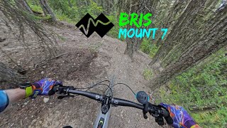
Bris is a short double black rated trail between the 10km and 5km trailheads. It is accessed off of Erich’s trail and then spits you out on the MT 7 shuttle road just up from the 5km entrance. It highlighted by its one steep and committing fall line section.

Bris is accessed after the gully crossing on Erich’s. Take the first and second rights (the second right being within 10 feet of first right) after the gully and you are now on Bris proper. One can’t miss this gully, as it’s the first uphill portion of Erich’s trail from the 10K trailhead entrance. There used to be a 40 foot wooden bridge across the span until it was taken out by deadfall a few years back.

The trail starts out flowy and traverses across the contour with several tighter corners here and there. The trail then enters an obvious sustained steep section. There are multiple lines, but all are mostly fall line and there is no ride around. Once you pass the steep test, the trail regains a bit more flow and you can carry good speed to its exit out to the road.

From where Bris spits you out on the road, you can then ride up the road for 1km to hit the B12 entrance, or instead just continue down the road for 200m to reach the entrance for 5K.

Note: because of the silty soils of Bris, it is an absolute grease track when wet and should be avoided in such conditions.

Access Info

Bris is accessed after the gully crossing on Erich’s. Take the first and second rights (the second right being within 10 feet of first right) after the gully and you are now on Bris proper. One can’t miss this gully, as it’s the first uphill portion of Erich’s trail from the 10K trailhead entrance.

Local Trail Association
Traditionally Indigenous Territory
More Stats for Bris mountain bike trail trail
  • Altitude change
    -783 ft
  • Altitude min
    4,143 ft
  • Altitude max
    4,927 ft
  • Altitude start
    4,927 ft
  • Altitude end
    4,144 ft
  • Grade
    -24.3%
  • Grade max
    -74.3%
  • Grade min
    0.7%
  • Distance down
    3,087 ft
  • Distance flat
    131 ft
  • Avg time
    00:08:49
  • view trail stats
Status:
on Apr 28, 2025
Variable
Avg: 3.84 (7 votes)
Your vote: 0

view (273)
close
3D
Trail Conditions
  • Unknown
  • Snow Groomed
  • Snow Packed
  • Snow Covered
  • Snow Cover Partial
  • Freeze/thaw Cycle
  • Icy
  • Prevalent Mud
  • Wet
  • Variable
  • Ideal
  • Dry
  • Very Dry
Trail Flow (Ridden Direction)
Trailforks scans users ridelogs to determine the most popular direction each trail is ridden. A good flowing trail network will have most trails flowing in a single direction according to their intension.
The colour categories are based on what percentage of riders are riding a trail in its intended direction.
  • > 96%
  • > 90%
  • > 80%
  • > 70%
  • > 50%
  • < 50%
  • bi-directional trail
  • no data
Trail Last Ridden
Trailforks scans ridelogs to determine the last time a trail was ridden.
  • < 2 days
  • < 1 week
  • < 2 weeks
  • < 1 month
  • < 6 months
  • > 6 months
Trail Ridden Direction
The intended direction a trail should be ridden.
  • Downhill Only
  • Downhill Primary
  • Both Directions
  • Uphill Primary
  • Uphill Only
  • One Direction
Contribute Details
Colors indicate trail is missing specified detail.
  • Description
  • Photos
  • Description & Photos
  • Videos
Trail Popularity ?
Trailforks scans ridelogs to determine which trails are ridden the most in the last 9 months. Trails are compared with nearby trails in the same city region with a possible 25 colour shades. Think of this as a heatmap, more rides = more kinetic energy = warmer colors.
  • most popular
  • popular
  • less popular
  • not popular
ATV/ORV/OHV Filter
Max Vehicle Width
inches
US Cell Coverage
Legend
cell carrier legend

Radar Time
x Activity Recordings
Trailforks users anonymized public ridelogs from the past 6 months.
  • mountain biking recent
  • mountain biking (>6 month)
  • hiking (1 year)
  • moto (1 year)
Activity Recordings
Trailforks users anonymized public skilogs from the past 12 months.
  • Downhill Ski
  • Backcountry Ski
  • Nordic Ski
  • Snowmobile
Winter Trails
Warning A routing network for winter maps does not exist. Selecting trails using the winter trails layer has been disabled.
x Missing Trails
Most Popular
Least Popular
Trails are colored based on popularity. The more popular a trail is, the more red. Less popular trails trend towards green.
Jump Magnitude Heatmap
Heatmap of where riders jump on trails. Zoom in to see individual jumps, click circles to view jump details.
Trails Deemphasized
Trails are shown in grey.
disable
Only show trails with NO bikes.
enable

Save the current map location and zoom level as your default home location whenever this page is loaded.

Save
      Directions to bris trailhead (51.276800, -116.900370)
      update trails status or condition

      Bris Trail Reports

      statusdatedescription
      Apr 28, 2025 @ 9:22am
      Apr 28, 2025
      reporter Only accessible by pedalling up the Schacher.
      Mar 12, 2025 @ 12:24pm
      Mar 12, 2025
      reporter Even though it feels like the start of the riding season the trails are still not good to go. Even the sunny slopes have sections with snow and...
      May 25, 2024 @ 1:50pm
      May 25, 2024
      May 7, 2024 @ 4:23pm
      May 7, 2024
      reporter
      Mar 18, 2024 @ 9:51am
      Mar 18, 2024
      reporter Even though it feels like the start of the riding season the trails are still not good to go. Even the sunny slopes have sections with snow and...
      view all reports »

      Recent Ridelog Activity on Trail

      Past Week
      • 0 rides
      •  
      6 Months
      • 0 rides
      •  
      All
      • 27 rides
      • Last: May 4, 2025

      Photos

      more »
      10 |
      Aug 28, 2022 @ 8:26pm
      Aug 28, 2022

      Reviews / Comments

      No reviews yet, be the first to write a review or ask a question.
      Use trail reports to comment on trail conditions.


      We hope you've been enjoying Trailforks!

      Create a FREE account to view trail comments and much more.

      Videos

      more »
      Bris - Mount 7
      8:16 | 18 | Apr 26, 2025 , Golden

      Nearby Trails

      • By canadakaTF Pro Trailforks & contributors
      • #3453 - 3,465 views

      You must enter a description before submitting.