4,390 ft
Distance
8 ft
Climb
-778 ft
Descent
00:15:29
Avg time
Supporters, Builders, Maintainers & Land Managers of Cakewalk Trail
- Dream Wizards
since 2000Builder - Dream Wizards
since 2000Maintainer
Cakewalk Details
-
Activities
- Mountain Bike
- E-Bike
-
Riding AreaDiamond Head
Squamish, British Columbia -
Difficulty Rating
-
Voted DifficultyBlack Diamond (6 votes)
-
Trail TypeSingletrack
-
Bike TypeDH, AM
-
DirectionDownhill OnlyPopular direction shown
-
Trail VisibilityAlways easy to follow
-
Dogs AllowedYes
-
eBike AllowedYes up to Class 1
-
TTFs on TrailBridge, Drop, Gap Jump, Rock Face
-
Ride in RainYes
-
Global Ranking
-
Local Popularity90 in Mountain Biking [+]
- 80 in E-Biking
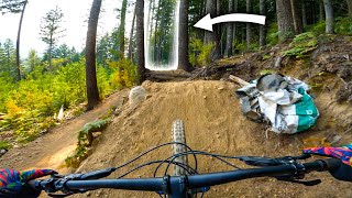
Cakewalk was build as a easier alternative to the other downhill trails, but don’t let the name fool you. The trail is old, wet, rooty, rocky and has not seen very much maintenance. This is a downhill trail with a few optional challenges if you know where to look. Cakewalk has become a popular way to access Full Nelson.
Local Trail Association
-
Please consider joining or donating to the local trail association to supportdonate to earn trail karma!
trail development & maintenance.
Traditionally Indigenous Territory
More Stats for Cakewalk mountain bike trail trail
-
Altitude change-770 ft
-
Altitude min1,451 ft
-
Altitude max2,229 ft
-
Altitude start2,229 ft
-
Altitude end1,460 ft
-
Grade-17.5%
-
Grade max-64.7%
-
Grade min5%
-
Distance climb230 ft
-
Distance down4,072 ft
-
Distance flat85 ft
-
Avg time00:15:29
-
Avg reverse time00:07:19
- view trail stats
close
3D
Trail Conditions
- Unknown
- Snow Groomed
- Snow Packed
- Snow Covered
- Snow Cover Partial
- Freeze/thaw Cycle
- Icy
- Prevalent Mud
- Wet
- Variable
- Ideal
- Dry
- Very Dry
Trail Flow (Ridden Direction)
Trailforks scans users ridelogs to determine the most popular direction each trail is ridden. A good flowing trail network will have most trails flowing in a single direction according to their intension.
The colour categories are based on what percentage of riders are riding a trail in its intended direction.
- > 96%
- > 90%
- > 80%
- > 70%
- > 50%
- < 50%
- bi-directional trail
- no data
Trail Last Ridden
Trailforks scans ridelogs to determine the last time a trail was ridden.
- < 2 days
- < 1 week
- < 2 weeks
- < 1 month
- < 6 months
- > 6 months
Trail Ridden Direction
The intended direction a trail should be ridden.
- Downhill Only
- Downhill Primary
- Both Directions
- Uphill Primary
- Uphill Only
- One Direction
Contribute Details
Colors indicate trail is missing specified detail.
- Description
- Photos
- Description & Photos
- Videos
Trail Popularity ?
Trailforks scans ridelogs to determine which trails are ridden the most in the last 9 months.
Trails are compared with nearby trails in the same city region with a possible 25 colour shades.
Think of this as a heatmap, more rides = more kinetic energy = warmer colors.
- most popular
- popular
- less popular
- not popular
ATV/ORV/OHV Filter
Max Vehicle Width
inches
US Cell Coverage
Legend
Radar Time
x
Activity Recordings
Trailforks users anonymized public ridelogs from the past 6 months.
- mountain biking recent
- mountain biking (>6 month)
- hiking (1 year)
- moto (1 year)
Activity Recordings
Trailforks users anonymized public skilogs from the past 12 months.
- Downhill Ski
- Backcountry Ski
- Nordic Ski
- Snowmobile
Winter Trails
Warning
A routing network for winter maps does not exist. Selecting trails using the winter trails layer has been disabled.
x
Missing Trails
Most Popular
Least Popular
Trails are colored based on popularity. The more popular a trail is, the more red. Less popular trails trend towards green.
Jump Magnitude Heatmap
Heatmap of where riders jump on trails. Zoom in to see individual jumps, click circles to view jump details.
Trails Deemphasized
Trails are shown in grey.
Only show trails with NO bikes.
Save the current map location and zoom level as your default home location whenever this page is loaded.
Save
Directions to cakewalk trailhead
(49.740900, -123.034420)
Articles
Video: All The Episodes From Full Enduro
Jan 1, 2020 from pinkbike.com
Zoe Dawson is a Squamish local who has been riding XC for years, but her skills simply didn't translate to enduro...
Video: The Privateer Puts His Training to the Test on the Pinkbike Hot Lap
Dec 11, 2019 from pinkbike.com
The Privateer, Adam Price, takes on the Pinkbike Hot Lap.
Video: Eddie Masters & Matt Walker Send The Brodie 8-Ball Down The Pinkbike Hot Lap
Sep 11, 2019 from pinkbike.com
See Eddie Masters and Matt Walker tackle the Pinkbike Hot Lap on a Brodie 8-Ball from 2002.
update trails status or condition
Cakewalk Trail Reports
view all reports »
Recent Ridelog Activity on Trail
Past Week
- 7 rides
- 12 miles avg distance
6 Months
- 39 rides
- 10 miles avg distance
All
- 700 rides
- Last: Apr 18, 2025
Photos
more »
Routes with this trail
more »
Trail Products
-
SORCA Trail SupporterTrail Pass
Pinkbike Articles
Jan 1, 2020

Zoe Dawson is a Squamish local who has been riding XC for years, but her skills simply didn't translate to enduro...
Dec 11, 2019

The Privateer, Adam Price, takes on the Pinkbike Hot Lap.
Sep 11, 2019

See Eddie Masters and Matt Walker tackle the Pinkbike Hot Lap on a Brodie 8-Ball from 2002.
22 Reviews & Comments
We hope you've been enjoying Trailforks!
Create a FREE account to view trail comments and much more.
Videos
more »
Nearby Trails
- One Trick Pony 1 mile
- Lower One Man's Garbage 1 mile
- Full Nelson 1 mile
- Cakewalk - Full Nelson Access 2 miles
- Elfin Lakes 2 miles
- By canadaka
Trailforks & contributors
- #5074 - 24,973 views
- follow/subscribe
- login to download gpx or kml files.
You must enter a description before submitting.