more stats
10.9 miles
Distance
1,858 ft
Climb
-972 ft
Descent
00:55:39
Avg time
886 ft
Altitude change
142 ft
Altitude min
1,513 ft
Altitude max
142 ft
Altitude start
1,027 ft
Altitude end
1.5%
Grade
-18.2%
Grade max
37.7%
Grade min
6 miles
Distance climb
4 miles
Distance down
2,014 ft
Distance flat
00:55:39
Avg time

Central Rd Details

  • Activities
    • Mountain Bike
    • E-Bike
    • Gravel Bike
    • Adaptive Bike
    • Hike
    • Trail Running
  • Riding Area
  • Difficulty Rating
  • Local Popularity
    40 in Mountain Biking [+]
    • 5 in Trail Running
    • 5 in Hiking
  • Trail Type
    Dirt/Gravel Road
  • Bike Type
    Adaptive MTB, Gravel
  • Climb Difficulty
    Blue
  • Dogs Allowed
    Yes
  • eBike Allowed
    Yes up to Class 1
  • Land Owner

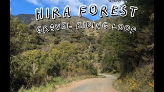
Forest road access to Loam Ranger, Mr Chomper, Maitai Face (full) and Keyboard Warrior

Access Info

Central road is a public access easement, you don't require a permit to ride it, it's public access. However occasionally forestry may close down access for forestry operations, Please pay heed to all forestry signage pertaining to this, or contact Tasman pine forests limited for information on access status

Recent Activity on Trail

Past Week
  • 0 rides
  •  
6 Months
  • 0 rides
  •  
All
  • 22 rides
  • Last: Jun 28, 2026
c1c2c3c4
January
February
March
April
May
June
July
August
September
October
November
December
update trails status or condition

Central Rd Trail Reports

statusdatedescription
Jun 9, 2026 @ 2:00pm (Pacific/Auckland)
Jun 8, 2026
reporter Central Road access is closed from Sharlands Road but open from locked gate at about 2.5km mark. Access possible via the Te Piki Climbing Trail...
May 10, 2026 @ 1:04pm (Pacific/Auckland)
May 9, 2026
probably alright in weekends, came in from whangamoa saddle today, no closed signs, no trucks on road
May 10, 2026 @ 1:02pm (Pacific/Auckland)
May 9, 2026
May 4, 2026 @ 10:23pm (Pacific/Auckland)
May 4, 2026
Rode in today. No signage at teal saddle to indicate closed, but ran into logging trucks at...
May 1, 2026 @ 6:07pm (Pacific/Auckland)
Apr 30, 2026
public access only open from teal saddle to whangamoa saddle
more »
Status:
on Jun 9, 2026
no votes yet
Your vote: 0

view (746)
close
3D
Trail Conditions
  • Unknown
  • Snow Groomed
  • Snow Packed
  • Snow Covered
  • Snow Cover Partial
  • Freeze/thaw Cycle
  • Icy
  • Prevalent Mud
  • Wet
  • Variable
  • Ideal
  • Dry
  • Very Dry
Trail Flow (Ridden Direction)
Trailforks scans users ridelogs to determine the most popular direction each trail is ridden. A good flowing trail network will have most trails flowing in a single direction according to their intension.
The colour categories are based on what percentage of riders are riding a trail in its intended direction.
  • > 96%
  • > 90%
  • > 80%
  • > 70%
  • > 50%
  • < 50%
  • bi-directional trail
  • no data
Trail Last Ridden
Trailforks scans ridelogs to determine the last time a trail was ridden.
  • < 2 days
  • < 1 week
  • < 2 weeks
  • < 1 month
  • < 6 months
  • > 6 months
Trail Ridden Direction
The intended direction a trail should be ridden.
  • Downhill Only
  • Downhill Primary
  • Both Directions
  • Uphill Primary
  • Uphill Only
  • One Direction
Contribute Details
Colors indicate trail is missing specified detail.
  • Description
  • Photos
  • Description & Photos
  • Videos
Trail Popularity ?
Trailforks scans ridelogs to determine which trails are ridden the most in the last 9 months. Trails are compared with nearby trails in the same city region with a possible 25 colour shades. Think of this as a heatmap, more rides = more kinetic energy = warmer colors.
  • most popular
  • popular
  • less popular
  • not popular
ATV/ORV/OHV Filter
Max Vehicle Width
inches
US Cell Coverage
Legend
cell carrier legend

Radar Time
Activity Recordings
Trailforks uses anonymized public activity data. ?
Activity Recordings
Trailforks uses anonymized public activity data. ?
Personal Heatmap
Activity Types
all / none
Options
2
Date range month
Winter Trails
Warning A routing network for winter maps does not exist. Selecting trails using the winter trails layer has been disabled.
Missing Trails
Most Popular
Least Popular
Trails are colored based on popularity. The more popular a trail is, the more red. Less popular trails trend towards green.
Jump Magnitude Heatmap
Heatmap of where riders jump on trails. Zoom in to see individual jumps, click circles to view jump details.
BC Backroad Status

Service Road Atlas is a free to use, community-driven service for viewing and creating reports on the numerous back-country service roads around B.C. and Alberta.

map legend
Slope Aspect
Direction the slope faces
Flat N NE E SE S SW W NW
Trails Deemphasized
Trails are shown in grey.
disable
Only show trails with no bike usage.
Enable
Suggested Layers
Based on selected activity type

    Save the current map location and zoom level as your default home location whenever this page is loaded.

    Save
        Directions to central-rd trailhead (-41.275960, 173.328710)

        Photos

        No photos have been added for Central Rd yet, add a photo.

        Videos

        0 more »
        Hira Forest Gravel  loop
        9:41 | 70 | Sep 23, 2025 , Nelson

        Routes with this trail

        32 miles 3,102 ft 5 Loop
        Awesome Gravel Road Loop Make sure you stop at Hira Dairy for an Ice Cream ( see POI) Please check the...
        Pick & Mix Featured
        20 miles 4,603 ft 45 Loop
        Approx Ride Time: 3-4.5 Hours including stops. Permits: Permits are required, see...
        10 miles 2,171 ft 11 Point to Point Race
        Aorere Enduro - Asia - Pacific Continental Round 1 Day 1

        Reviews / Comments

        No reviews yet, be the first to write a review or ask a question.
        Use trail reports to comment on trail conditions.


        We hope you've been enjoying Trailforks!

        Create a FREE account to view trail comments and much more.

        • By NMTBCTF Pro NMTBC & contributors
        • #119567 - 1,592 views

        Frequently Asked Questions About Central Rd

        Where is Central Rd located?
        Central Rd is located in Waitarake/Sharlands, Nelson, New Zealand. It is part of the Waitarake/Sharlands trail network. The trailhead is located at coordinates -41.27596, 173.32871.
        What is the elevation gain for Central Rd?
        Central Rd has 1,858 ft of elevation gain. The trail has 972 ft of elevation descent. The elevation ranges from 142 ft to 1,513 ft.
        How long is Central Rd?
        Central Rd is 10.9 miles long. The trail type is dirt/gravel road.
        Are dogs allowed on Central Rd?
        Yes, dogs are allowed on Central Rd. Please keep dogs on a leash where required and clean up after them.

        Hit the Trail

        Open in App

        Get this trail on your phone instantly.
        open trail in app

        Download Trail

        Save to wishlist, Garmin & download.
        save the trail

        Find Related Routes

        Find routes and users activities that include this trail.
        find routes for this trail

        You must enter a description before submitting.