more stats
4,446 ft
Distance
42 ft
Climb
-455 ft
Descent
00:04:49
Avg time
-413 ft
Altitude change
3,978 ft
Altitude min
4,402 ft
Altitude max
4,402 ft
Altitude start
3,990 ft
Altitude end
-9.3%
Grade
-36.5%
Grade max
14.5%
Grade min
715 ft
Distance climb
3,248 ft
Distance down
387 ft
Distance flat
00:04:49
Avg time

Contra Details

  • Activities
    • Mountain Bike
    • E-Bike
    • Hike
    • Trail Running
  • Riding Area
    Ridgemont
    Fernie, British Columbia
  • Difficulty Rating
  • Voted Difficulty
    Blue (1 vote)
  • Local Popularity
    85 in Mountain Biking [+]
    • 100 in E-Biking
    • 45 in Trail Running
    • 50 in Hiking
  • Global Ranking
    #26461 in Mountain Biking [+]
    • #2074 in E-Biking
    • #107606 in Trail Running
    • #85803 in Hiking
  • Trail Type
    Machine Groomed
  • Bike Type
    DH, AM, DJ
  • Direction
    Downhill Only
  • Dogs Allowed
    Yes
  • eBike Allowed
    Yes up to Class 1
  • TTFs on Trail
    Berm, Jump
  • Year Opened
    2018
  • Land Owner
    Parastone

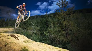
The much anticipated Fernie flow trail. Full of tables, berms, and great views. Fun for everyone. Send it.

Be sure to scout it out properly before reaching warp speed.

Access Info

Off of Rifle Range Road Spur 1 - see map. Either ride up Rifle Range Road, or come over the top from Ridgemont.

Traditionally Indigenous Territory

Recent Activity on Trail

Past Week
  • 3 rides
  • 14 miles average
6 Months
  • 23 rides
  • 12 miles avg distance
All
  • 525 rides
  • Last: Jun 26, 2026
c1c2c3c4
January
February
March
April
May
June
July
August
September
October
November
December
update trails status or condition

Contra Trail Reports

statusdatedescription
Jun 17, 2026 @ 12:12pm (America/Edmonton)
Jun 17, 2026
reporter The ramp to the whale tail has been pulled back another 16" so it works with a bit more speed. Also the gap has been filled in with a bridge so...
May 9, 2026 @ 7:16am (America/Edmonton)
May 9, 2026
reporter Contra has new features at the top, with a new wood drop and a whale tail feature. Note that the whale tail entry ramp has been moved since it...
Apr 28, 2026 @ 2:18pm (America/Edmonton)
Apr 28, 2026
reporter Contra is now open all the way with new features at the top.
Apr 19, 2026 @ 12:50pm (America/Edmonton)
Apr 19, 2026
reporter Trail Dogs and Contra remain closed at the top due to erosion issues on some landings that are a safety concern. They are both open from a mid...
Mar 24, 2026 @ 10:38am (America/Edmonton)
Mar 24, 2026
UpDog, Trail Dogs and Contra are all closed until the snow melts and the trails firm up so that riding doesn't cause trail damage. Thank you for...
more »
Status:
on Jun 17, 2026
Avg: 4.31 (24 votes)
Your vote: 0

view (3,987)
close
3D
Trail Conditions
  • Unknown
  • Snow Groomed
  • Snow Packed
  • Snow Covered
  • Snow Cover Partial
  • Freeze/thaw Cycle
  • Icy
  • Prevalent Mud
  • Wet
  • Variable
  • Ideal
  • Dry
  • Very Dry
Trail Flow (Ridden Direction)
Trailforks scans users ridelogs to determine the most popular direction each trail is ridden. A good flowing trail network will have most trails flowing in a single direction according to their intension.
The colour categories are based on what percentage of riders are riding a trail in its intended direction.
  • > 96%
  • > 90%
  • > 80%
  • > 70%
  • > 50%
  • < 50%
  • bi-directional trail
  • no data
Trail Last Ridden
Trailforks scans ridelogs to determine the last time a trail was ridden.
  • < 2 days
  • < 1 week
  • < 2 weeks
  • < 1 month
  • < 6 months
  • > 6 months
Trail Ridden Direction
The intended direction a trail should be ridden.
  • Downhill Only
  • Downhill Primary
  • Both Directions
  • Uphill Primary
  • Uphill Only
  • One Direction
Contribute Details
Colors indicate trail is missing specified detail.
  • Description
  • Photos
  • Description & Photos
  • Videos
Trail Popularity ?
Trailforks scans ridelogs to determine which trails are ridden the most in the last 9 months. Trails are compared with nearby trails in the same city region with a possible 25 colour shades. Think of this as a heatmap, more rides = more kinetic energy = warmer colors.
  • most popular
  • popular
  • less popular
  • not popular
ATV/ORV/OHV Filter
Max Vehicle Width
inches
US Cell Coverage
Legend
cell carrier legend

Radar Time
Activity Recordings
Trailforks uses anonymized public activity data. ?
Activity Recordings
Trailforks uses anonymized public activity data. ?
Personal Heatmap
Activity Types
all / none
Options
2
Date range month
Winter Trails
Warning A routing network for winter maps does not exist. Selecting trails using the winter trails layer has been disabled.
Missing Trails
Most Popular
Least Popular
Trails are colored based on popularity. The more popular a trail is, the more red. Less popular trails trend towards green.
Jump Magnitude Heatmap
Heatmap of where riders jump on trails. Zoom in to see individual jumps, click circles to view jump details.
BC Backroad Status

Service Road Atlas is a free to use, community-driven service for viewing and creating reports on the numerous back-country service roads around B.C. and Alberta.

map legend
Slope Aspect
Direction the slope faces
Flat N NE E SE S SW W NW
Trails Deemphasized
Trails are shown in grey.
disable
Only show trails with no bike usage.
Enable
Suggested Layers
Based on selected activity type

    Save the current map location and zoom level as your default home location whenever this page is loaded.

    Save
        Directions to contra trailhead (49.507870, -115.020790)

        Photos

        39 more »
        4 |
        Jun 25, 2026 @ 6:45am
        3 days
        88 |
        Oct 8, 2024 @ 6:52am
        Oct 8, 2024
        69 |
        Jul 29, 2024 @ 1:23pm
        Jul 29, 2024
        131 |
        Jul 24, 2022 @ 11:51am
        Jul 24, 2022

        Videos

        10 more »
        youtuber A Technical Jump Line? - Contra, Fernie, BC
        2:44 | 1676 | Aug 27, 2020 , Fernie
        youtuber Getting Redemption on an Advanced Jump Line
        13:49 | 618 | Aug 27, 2020 , Fernie
        youtuber INTO THE FERNIE STEEPS with BCPOV // Dirt Epic...
        20:39 | 941 | Sep 18, 2018 , Fernie
        Contra to Traildog, local trails in Fernie, BC
        8:38 | 259 | Dec 30, 2023 , Fernie

        Routes with this trail

        7 miles 1,115 ft 10
        easy climb through ridgemont with downhill on contra. loop back on heritage trail at end
        52 miles 8,166 ft 8 Race
        Where small town charm meets adventure in the heart of the Canadian Rocky Mountains. Fernie is a historic...

        7 Reviews & Comments


        We hope you've been enjoying Trailforks!

        Create a FREE account to view trail comments and much more.

        • By Dannyzm1TF Pro & contributors
        • #136998 - 16,828 views

        Frequently Asked Questions About Contra

        Where is Contra located?
        Contra is located in Ridgemont, Fernie, British Columbia, Canada. It is part of the Ridgemont trail network. The trailhead is located at coordinates 49.50787, -115.02079.
        How hard is Contra?
        Contra is rated as Black Diamond difficulty. The average grade is 9.3%.
        What is the elevation gain for Contra?
        Contra has 42 ft of elevation gain. The trail has 455 ft of elevation descent. The elevation ranges from 3,978 ft to 4,402 ft.
        Is Contra a point to point trail?
        Yes, Contra is a point to point trail. The direction is Downhill Only. The trail type is machine groomed.

        Hit the Trail

        Open in App

        Get this trail on your phone instantly.
        open trail in app

        Download Trail

        Save to wishlist, Garmin & download.
        save the trail

        Find Related Routes

        Find routes and users activities that include this trail.
        find routes for this trail

        You must enter a description before submitting.