1,637 ft
Distance
151 ft
Climb
00:04:39
Avg time
Cow Path Details
-
Activities
- Mountain Bike
- E-Bike
- Hike
- Trail Running
-
Riding AreaKingdom Trails
East Burke, Vermont -
Difficulty Rating
-
Trail TypeSingletrack
-
Bike TypeAM, XC
-
DirectionDownhill Only
-
Climb DifficultyBlack Diamond
-
Physical RatingHard
-
Trail VisibilityAlways easy to follow
-
eBike Allowed
-
Global Ranking
-
Local Popularity30 in Mountain Biking [+]
- 40 in E-Biking
- 5 in Trail Running
- 30 in Hiking
-
Land OwnerKingdom Trail Association
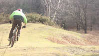
Cow Path is a challenging yet fun short trail, suitable for confident/skilled novices and above. The trail has a significant elevation change, making for a great climbing trail or a fun, fast downhill. The trail surface is relatively solid with no significant obstacles.
Local Trail Association
-
Please consider joining or donating to the local trail association to supportdonate to earn trail karma!
trail development & maintenance.
Traditionally Indigenous Territory
More Stats for Cow Path multi-use trail trail
-
Altitude change151 ft
-
Altitude min870 ft
-
Altitude max1,022 ft
-
Altitude start870 ft
-
Altitude end1,020 ft
-
Grade9.2%
-
Grade max-0.8%
-
Grade min37.2%
-
Distance climb1,516 ft
-
Distance down82 ft
-
Distance flat36 ft
-
Avg time00:04:39
-
Avg reverse time00:02:03
- view trail stats
close
3D
Trail Conditions
- Unknown
- Snow Groomed
- Snow Packed
- Snow Covered
- Snow Cover Partial
- Freeze/thaw Cycle
- Icy
- Prevalent Mud
- Wet
- Variable
- Ideal
- Dry
- Very Dry
Trail Flow (Ridden Direction)
Trailforks scans users ridelogs to determine the most popular direction each trail is ridden. A good flowing trail network will have most trails flowing in a single direction according to their intension.
The colour categories are based on what percentage of riders are riding a trail in its intended direction.
- > 96%
- > 90%
- > 80%
- > 70%
- > 50%
- < 50%
- bi-directional trail
- no data
Trail Last Ridden
Trailforks scans ridelogs to determine the last time a trail was ridden.
- < 2 days
- < 1 week
- < 2 weeks
- < 1 month
- < 6 months
- > 6 months
Trail Ridden Direction
The intended direction a trail should be ridden.
- Downhill Only
- Downhill Primary
- Both Directions
- Uphill Primary
- Uphill Only
- One Direction
Contribute Details
Colors indicate trail is missing specified detail.
- Description
- Photos
- Description & Photos
- Videos
Trail Popularity ?
Trailforks scans ridelogs to determine which trails are ridden the most in the last 9 months.
Trails are compared with nearby trails in the same city region with a possible 25 colour shades.
Think of this as a heatmap, more rides = more kinetic energy = warmer colors.
- most popular
- popular
- less popular
- not popular
ATV/ORV/OHV Filter
Max Vehicle Width
inches
US Cell Coverage
Legend
Radar Time
x
Activity Recordings
Trailforks users anonymized public ridelogs from the past 6 months.
- mountain biking recent
- mountain biking (>6 month)
- hiking (1 year)
- moto (1 year)
Activity Recordings
Trailforks users anonymized public skilogs from the past 12 months.
- Downhill Ski
- Backcountry Ski
- Nordic Ski
- Snowmobile
Winter Trails
Warning
A routing network for winter maps does not exist. Selecting trails using the winter trails layer has been disabled.
x
Missing Trails
Most Popular
Least Popular
Trails are colored based on popularity. The more popular a trail is, the more red. Less popular trails trend towards green.
Jump Magnitude Heatmap
Heatmap of where riders jump on trails. Zoom in to see individual jumps, click circles to view jump details.
Trails Deemphasized
Trails are shown in grey.
Only show trails with NO bikes.
Save the current map location and zoom level as your default home location whenever this page is loaded.
Save
Directions to cow-path trailhead
(44.563780, -71.963180)
update trails status or condition
Cow Path Trail Reports
view all reports »
Recent Ridelog Activity on Trail
Past Week
- 3 rides
- 22 miles avg distance
6 Months
- 3 rides
- 22 miles avg distance
All
- 229 rides
- Last: May 21, 2025
Photos
more »
Trail Lists
-
Summer SE Darling Hill
23 trails
Routes with this trail
Reviews / Comments
No reviews yet, be the first to write a review or ask a question.
Use trail reports to comment on trail conditions.
We hope you've been enjoying Trailforks!
Create a FREE account to view trail comments and much more.
Nearby Trails
- Easy Out 761 ft
- Sugar Hill / Cow Path Connector 1,371 ft
- Cowpath 1,378 ft
- Jaw 1,864 ft
- Maxilla 1,864 ft
- By brenthillier
NSMBA TRAILFORKS & contributors
- #9730 - 1,815 views
- follow/subscribe
- login to download gpx or kml files.
You must enter a description before submitting.