more stats
1,870 ft
Distance
6 ft
Climb
-244 ft
Descent
00:03:31
Avg time
-238 ft
Altitude change
1,265 ft
Altitude min
1,503 ft
Altitude max
1,503 ft
Altitude start
1,266 ft
Altitude end
-12.7%
Grade
-35.8%
Grade max
5.8%
Grade min
112 ft
Distance climb
1,568 ft
Distance down
190 ft
Distance flat
00:03:31
Avg time

Dasos Details

  • Activities
    • Mountain Bike
    • E-Bike
    • Trail Running
  • Riding Area
  • Difficulty Rating
  • Voted Difficulty
    Blue (7 votes)
  • Local Popularity
    100 in Mountain Biking [+]
    • 100 in E-Biking
    • 65 in Trail Running
  • Global Ranking
    #1893 in Mountain Biking [+]
    • #2015 in E-Biking
    • #60898 in Trail Running
  • Trail Type
    Singletrack
  • Bike Type
    AM
  • Direction
    Downhill Only
    Popular Direction Shown
  • Physical Rating
    Easy
  • Trail Visibility
    Always easy to follow
  • Dogs Allowed
    Yes
  • eBike Allowed
    Yes up to Class 1
  • TTFs on Trail
    Berm, Drop, Jump, Gap Jump, Rock Garden
  • Ride in Rain
    Yes
  • Land Owner

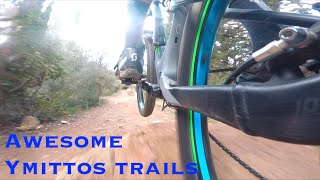
This is a trail built by Hellenic Mountain Bike Association members. Fairy easy, with nice features (berms and a couple of jumps). Fast trail that connects to a couple more trails in the area. Bonus feature are the ancient ruins of the St. Taxiarhes church at the end of the trail.

Local Trail Association

Recent Activity on Trail

Past Week
  • 2 rides
  • 11.1 km average
6 Months
  • 90 rides
  • 16.4 km avg distance
All
  • 1,056 rides
  • Last: Jul 3, 2026
c1c2c3c4
January
February
March
April
May
June
July
August
September
October
November
December
update trails status or condition

Dasos Trail Reports

Status:
on Jun 12, 2026
Dry
Avg: 4.58 (28 votes)
Your vote: 0

view (11,434)
close
3D
Trail Conditions
  • Unknown
  • Snow Groomed
  • Snow Packed
  • Snow Covered
  • Snow Cover Partial
  • Freeze/thaw Cycle
  • Icy
  • Prevalent Mud
  • Wet
  • Variable
  • Ideal
  • Dry
  • Very Dry
Trail Flow (Ridden Direction)
Trailforks scans users ridelogs to determine the most popular direction each trail is ridden. A good flowing trail network will have most trails flowing in a single direction according to their intension.
The colour categories are based on what percentage of riders are riding a trail in its intended direction.
  • > 96%
  • > 90%
  • > 80%
  • > 70%
  • > 50%
  • < 50%
  • bi-directional trail
  • no data
Trail Last Ridden
Trailforks scans ridelogs to determine the last time a trail was ridden.
  • < 2 days
  • < 1 week
  • < 2 weeks
  • < 1 month
  • < 6 months
  • > 6 months
Trail Ridden Direction
The intended direction a trail should be ridden.
  • Downhill Only
  • Downhill Primary
  • Both Directions
  • Uphill Primary
  • Uphill Only
  • One Direction
Contribute Details
Colors indicate trail is missing specified detail.
  • Description
  • Photos
  • Description & Photos
  • Videos
Trail Popularity ?
Trailforks scans ridelogs to determine which trails are ridden the most in the last 9 months. Trails are compared with nearby trails in the same city region with a possible 25 colour shades. Think of this as a heatmap, more rides = more kinetic energy = warmer colors.
  • most popular
  • popular
  • less popular
  • not popular
ATV/ORV/OHV Filter
Max Vehicle Width
inches
US Cell Coverage
Legend
cell carrier legend

Radar Time
Activity Recordings
Trailforks uses anonymized public activity data. ?
Activity Recordings
Trailforks uses anonymized public activity data. ?
Personal Heatmap
Activity Types
all / none
Options
2
Date range month
Winter Trails
Warning A routing network for winter maps does not exist. Selecting trails using the winter trails layer has been disabled.
Missing Trails
Most Popular
Least Popular
Trails are colored based on popularity. The more popular a trail is, the more red. Less popular trails trend towards green.
Jump Magnitude Heatmap
Heatmap of where riders jump on trails. Zoom in to see individual jumps, click circles to view jump details.
BC Backroad Status

Service Road Atlas is a free to use, community-driven service for viewing and creating reports on the numerous back-country service roads around B.C. and Alberta.

map legend
Slope Aspect
Direction the slope faces
Flat N NE E SE S SW W NW
Trails Deemphasized
Trails are shown in grey.
disable
Only show trails with no bike usage.
Enable
Suggested Layers
Based on selected activity type

    Save the current map location and zoom level as your default home location whenever this page is loaded.

    Save
        Directions to dasos trailhead (37.957810, 23.796500)

        Photos

        4 more »
        406 |
        Feb 4, 2018 @ 10:54am
        Feb 4, 2018
        500 |
        Nov 6, 2015 @ 5:00am
        Nov 6, 2015
        541 |
        Nov 6, 2015 @ 5:00am
        Nov 6, 2015
        621 |
        Nov 6, 2015 @ 5:01am
        Nov 6, 2015

        Videos

        7 more »
        youtuber Immitos lower trails, getting to know them...
        12:36 | 325 | Oct 6, 2021 , Athens
        youtuber Think it, plan it, and do something else at...
        11:45 | 261 | Dec 23, 2021 , Athens
        youtuber Imittos trails with good friends! MTB in Greece!
        6:06 | 251 | Dec 13, 2021 , Athens
        youtuber Follow me mode on a budget! And a couple of...
        12:25 | 263 | Jan 17, 2022 , Athens

        Routes with this trail

        15 miles 3,564 ft 17 Loop
        25km loop, 17 trails, 1000m Taxiarhes-Trizato-Red-Lagos Yperokeanio ( -karavara-Yperokeanio) Ypovrixio...

        1 Review & Comments


        We hope you've been enjoying Trailforks!

        Create a FREE account to view trail comments and much more.

        • By haristheodoropoulosTF Pro HMBA TRAILFORKS & contributors
        • #50102 - 6,996 views

        Frequently Asked Questions About Dasos

        Where is Dasos located?
        Dasos is located in Imittos Mountain, Athens, Greece. It is part of the Imittos Mountain trail network. The trailhead is located at coordinates 37.95781, 23.7965.
        How hard is Dasos?
        Dasos is rated as Green difficulty. The physical rating is Easy. The average grade is 12.7%.
        What is the elevation gain for Dasos?
        Dasos has 2 m of elevation gain. The trail has 74 m of elevation descent. The elevation ranges from 386 m to 458 m.
        Is Dasos a point to point trail?
        Yes, Dasos is a point to point trail. The direction is Downhill Only. The trail type is singletrack.

        Hit the Trail

        Open in App

        Get this trail on your phone instantly.
        open trail in app

        Download Trail

        Save to wishlist, Garmin & download.
        save the trail

        Find Related Routes

        Find routes and users activities that include this trail.
        find routes for this trail

        You must enter a description before submitting.