Devilcross Details
-
Activities
- Mountain Bike
- E-Bike
- Hike
- Trail Running
-
Riding AreaGalbraith
Bellingham, Washington -
Difficulty Rating
-
Voted DifficultyBlack Diamond (6 votes)
-
Trail TypeSingletrack
-
Bike TypeAM, XC
-
DirectionDownhill PrimaryPopular direction shown
-
Physical RatingModerate
-
Dogs AllowedYes
-
eBike Allowed
-
TTFs on TrailBridge, Drop, Rock Face
-
Ride in RainYes
-
Global Ranking
-
Local Popularity80 in Mountain Biking [+]
- 70 in E-Biking
- 45 in Trail Running
- 50 in Hiking
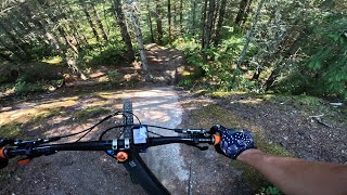
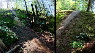
Devilcross starts off with a brief climb off of Keystone://www.trailforks.com/trails/keystone-165871/]Keystone[/L], then a few quick turns put you down at the logging road. Take a right, and an immediate left. About 100 yards down the road transitions to twisting fall-line single track, with some rock slabs and rock faces before the next road crossing. After the road crossing, The trail is fresher and the holes are bigger - the roots on this section can be challenging when it is wet. The fall line fun ends abruptly in a cedar bottomland with an off camber rock face, and the first of several creek crossings. From here the trail climbs and traverses over several creeks back toward North Galbraith. Big thanks to the Kona crew for opening up this terrain in the last few years.
Local Trail Association
-
Please consider joining or donating to the local trail association to supportdonate to earn trail karma!
trail development & maintenance.
Traditionally Indigenous Territory
More Stats for Devilcross mountain bike trail trail
-
Altitude change-553 ft
-
Altitude min880 ft
-
Altitude max1,475 ft
-
Altitude start1,467 ft
-
Altitude end915 ft
-
Grade-7.7%
-
Grade max-33.1%
-
Grade min25.2%
-
Distance climb1,604 ft
-
Distance down4,836 ft
-
Distance flat738 ft
-
Avg time00:19:11
-
Avg reverse time00:21:13
- view trail stats
- Unknown
- Snow Groomed
- Snow Packed
- Snow Covered
- Snow Cover Partial
- Freeze/thaw Cycle
- Icy
- Prevalent Mud
- Wet
- Variable
- Ideal
- Dry
- Very Dry
The colour categories are based on what percentage of riders are riding a trail in its intended direction.
- > 96%
- > 90%
- > 80%
- > 70%
- > 50%
- < 50%
- bi-directional trail
- no data
- < 2 days
- < 1 week
- < 2 weeks
- < 1 month
- < 6 months
- > 6 months
- Downhill Only
- Downhill Primary
- Both Directions
- Uphill Primary
- Uphill Only
- One Direction
- Description
- Photos
- Description & Photos
- Videos
- most popular
- popular
- less popular
- not popular
- mountain biking recent
- mountain biking (>6 month)
- hiking (1 year)
- moto (1 year)
- Downhill Ski
- Backcountry Ski
- Nordic Ski
- Snowmobile
Save the current map location and zoom level as your default home location whenever this page is loaded.
SaveDevilcross Trail Reports
Recent Ridelog Activity on Trail
- 3 rides
- 18 miles avg distance
- 62 rides
- 15 miles avg distance
- 560 rides
- Last: Jun 14, 2025
Photos
Trail Lists
-
Galbraith DH Trails
50 trails
-
Bellingham Tech
28 trails
Routes with this trail
Trail Events
Trail Products
9 Reviews & Comments
We hope you've been enjoying Trailforks!
Create a FREE account to view trail comments and much more.
Videos

Nearby Trails
- Keystone 1,050 ft
- Access Rd To Devilcross 1,099 ft
- Spur 1,099 ft
- Supercross 1,332 ft
- Wonderland 1,952 ft
- By kyleyoungtransition & contributors
- #9759 - 10,669 views
- follow/subscribe
- login to download gpx or kml files.
You must enter a description before submitting.