more stats
1.5 miles
Distance
-1,408 ft
Descent
00:12:27
Avg time
-1,408 ft
Altitude change
4,787 ft
Altitude min
6,195 ft
Altitude max
6,195 ft
Altitude start
4,787 ft
Altitude end
-17.6%
Grade
-50.5%
Grade max
0.3%
Grade min
1 mile
Distance down
105 ft
Distance flat
00:12:27
Avg time

Double Dog Details

  • Activities
    • Mountain Bike
  • Riding Area
    Silver Star Mountain Park
    Vernon, British Columbia
  • Difficulty Rating
  • Local Popularity
    85 in Mountain Biking
  • Global Ranking
    #22293 in Mountain Biking
  • Trail Type
    Singletrack
  • Bike Type
    DH
  • Physical Rating
    Hard
  • Season
    Summer
  • Dogs Allowed
    Yes
  • eBike Allowed
  • TTFs on Trail
    Bridge, Drop, Skinny, Teeter Totter, Wallride
  • Land Owner

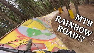
Home of the Red Bull Trail Crew Event, this trail is our token wooden feature trail, loaded with drops, wall rides, teeter-totters, roller coasters, great natural flow and a crafty little Slack Line feature that is sure to entertain.

Bike Park

Local Trail Association

Recent Activity on Trail

Past Week
  • 33 rides
  • 29 miles average
6 Months
  • 68 rides
  • 26 miles avg distance
All
  • 701 rides
  • Last: Jul 4, 2026
c1c2c3c4
January
February
March
April
May
June
July
August
September
October
November
December
update trails status or condition

Double Dog Trail Reports

statusdatedescription
Jun 18, 2026 @ 10:07pm (America/Vancouver)
Jun 18, 2026
Jun 18, 2026 @ 10:05pm (America/Vancouver)
Jun 18, 2026
Sep 23, 2025 @ 9:57am (America/Vancouver)
Sep 23, 2025
Thanks for another great season, ALL DH, Beowulf and upper XC trails are now closed. The Knoll XC will remain open until TBD.
Jun 21, 2025 @ 8:43am
Jun 21, 2025
Access via World Cup
Jun 20, 2025 @ 10:03am
Jun 20, 2025
more »
Status:
on Jun 18, 2026
Avg: 4.63 (53 votes)
Your vote: 0

view (5,215)
close
3D
Trail Conditions
  • Unknown
  • Snow Groomed
  • Snow Packed
  • Snow Covered
  • Snow Cover Partial
  • Freeze/thaw Cycle
  • Icy
  • Prevalent Mud
  • Wet
  • Variable
  • Ideal
  • Dry
  • Very Dry
Trail Flow (Ridden Direction)
Trailforks scans users ridelogs to determine the most popular direction each trail is ridden. A good flowing trail network will have most trails flowing in a single direction according to their intension.
The colour categories are based on what percentage of riders are riding a trail in its intended direction.
  • > 96%
  • > 90%
  • > 80%
  • > 70%
  • > 50%
  • < 50%
  • bi-directional trail
  • no data
Trail Last Ridden
Trailforks scans ridelogs to determine the last time a trail was ridden.
  • < 2 days
  • < 1 week
  • < 2 weeks
  • < 1 month
  • < 6 months
  • > 6 months
Trail Ridden Direction
The intended direction a trail should be ridden.
  • Downhill Only
  • Downhill Primary
  • Both Directions
  • Uphill Primary
  • Uphill Only
  • One Direction
Contribute Details
Colors indicate trail is missing specified detail.
  • Description
  • Photos
  • Description & Photos
  • Videos
Trail Popularity ?
Trailforks scans ridelogs to determine which trails are ridden the most in the last 9 months. Trails are compared with nearby trails in the same city region with a possible 25 colour shades. Think of this as a heatmap, more rides = more kinetic energy = warmer colors.
  • most popular
  • popular
  • less popular
  • not popular
ATV/ORV/OHV Filter
Max Vehicle Width
inches
US Cell Coverage
Legend
cell carrier legend

Radar Time
Activity Recordings
Trailforks uses anonymized public activity data. ?
Activity Recordings
Trailforks uses anonymized public activity data. ?
Personal Heatmap
Activity Types
all / none
Options
2
Date range month
Winter Trails
Warning A routing network for winter maps does not exist. Selecting trails using the winter trails layer has been disabled.
Missing Trails
Most Popular
Least Popular
Trails are colored based on popularity. The more popular a trail is, the more red. Less popular trails trend towards green.
Jump Magnitude Heatmap
Heatmap of where riders jump on trails. Zoom in to see individual jumps, click circles to view jump details.
BC Backroad Status

Service Road Atlas is a free to use, community-driven service for viewing and creating reports on the numerous back-country service roads around B.C. and Alberta.

map legend
Slope Aspect
Direction the slope faces
Flat N NE E SE S SW W NW
Trails Deemphasized
Trails are shown in grey.
disable
Only show trails with no bike usage.
Enable
Suggested Layers
Based on selected activity type

    Save the current map location and zoom level as your default home location whenever this page is loaded.

    Save
        Directions to double-dog trailhead (50.369500, -119.063730)

        Photos

        210 more »
        60 |
        Jul 29, 2023 @ 9:37pm
        Jul 29, 2023
        77 |
        Aug 11, 2022 @ 9:18am
        Aug 11, 2022
        79 |
        Aug 11, 2022 @ 9:18am
        Aug 11, 2022
        65 |
        Aug 11, 2022 @ 9:18am
        Aug 11, 2022

        Videos

        49 more »
        youtuber
        15:43 | 1141 | Nov 30, 2018 , Vernon
        youtuber This Bike Park Has Some Pretty Weird Features..
        15:03 | 854 | Jul 30, 2020 , Vernon
        This Bike Park Has it All | Silver Star
        1:18:07 | 212 | Sep 20, 2023 , Vernon
        So Many Features | Opening Weekend Silver Star
        10:03 | 279 | Jul 1, 2022 , Vernon

        Trail Lists

        Routes with this trail

        The Big 6 Featured
        5.0 82 miles 11,717 ft 32 Point to Point
        This is an epic ride, Ed Callenders "EdMondo" route completed in 2019 has been updated to include the...
        79 miles 10,654 ft 102 Point to Point
        Connect all the networks in the Vernon area, exact trails can be changed but must ride entire route, no...
        20 miles 4,740 ft 13 Loop Race
        2024 Juliana Bombshell Enduro Brought to you by NOCS and Juliana Bicycles. Let's do this gals The route...

        5 Reviews & Comments


        We hope you've been enjoying Trailforks!

        Create a FREE account to view trail comments and much more.

        • By canadakaTF Pro Trailforks & contributors
        • #3358 - 9,455 views

        Frequently Asked Questions About Double Dog

        Where is Double Dog located?
        Double Dog is located in Silver Star Mountain Park, Vernon, British Columbia, Canada. It is part of the Silver Star Mountain Park trail network. The trailhead is located at coordinates 50.3695, -119.06373.
        How hard is Double Dog?
        Double Dog is rated as Black Diamond difficulty. The physical rating is Hard. The average grade is 17.6%.
        What is the elevation gain for Double Dog?
        The trail has 1,408 ft of elevation descent. The elevation ranges from 4,787 ft to 6,195 ft.
        How long is Double Dog?
        Double Dog is 1.5 miles long. The trail type is singletrack.

        Hit the Trail

        Open in App

        Get this trail on your phone instantly.
        open trail in app

        Download Trail

        Save to wishlist, Garmin & download.
        save the trail

        Find Related Routes

        Find routes and users activities that include this trail.
        find routes for this trail

        You must enter a description before submitting.