


Open in App
Get this trail on your phone instantly.

Overview
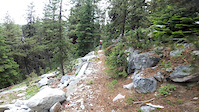
You want rock? Maybe more rock than you can handle? Then get ready to scare yourself silly. This trail is chunky, fast, AND narrow, with tight switchbacks thrown in to keep you guessing. While the out-and-back nature of this ride can be physically demanding, it does give you the opportunity to scope the line on the way up, because it all comes at you fast (and with consequences) on the way down. Fortunately, the lower half of the trail is mellower but not any less fun, and the larch needles create a twisty, golden ribbon of drift punctuated by rocky chutes.
Route Details
To get to the trailhead, take the scenic Anthony Lakes Highway towards the ski resort. Turn left onto NF-7307 and drive back to the trailhead. You can also park at the beginning of NF-7307 if you want to be gentle to your vehicle.
You’ll begin climbing immediately, through a beautiful evergreen forest. If you’ve had the good luck to visit in the fall, you’ll be rewarded with one of the conifer forest’s most stunning sights: the soft, golden rain of falling larch needles. It is an ethereal experience, like riding through a gentle snowfall of gold gilt. Regardless of the season, you’ll be thankful that the climb starts at a reasonable grade to let your legs warm up. However, there is no hiding the fact that you’re climbing above 5,000’.
About 5.5 miles into the ride you’ll edge close to the namesake Dutch Flat Meadow, a gorgeous, remote basin with primitive campsites. Take a break to enjoy the view because you’re about to grunt up the last two miles to the top. While not necessarily steep, the final climb is narrow and rocky, adding extra challenge to the thin air.
Your destination is the intersection of the Elk Horn Crest Trail, where you’ll top out just shy of 8K’. Drop your bike and take a quick stroll along the crest to savor the stunning views that are unparalleled in the state, looking deep into central Oregon to the west and across to Idaho to the east. Once you have a sufficient amount of photos for your social media feed, it’s time to prepare yourself for the task at hand: reaping the rewards of your climb.
As you may have surmised on your way up, the descent is amazing. Chunky granite boulders reward sniper-precision line choice while the narrow tread will have you death-gripping your bars. The switchbacks come up fast and many require a rear-wheel hop to clean: no bermed-out turns here in the backcountry, my friend. If you can on-sight the descent without dabbing, you’re better than most.
While the exposed descending can be nerve-wracking fun, it ends once you hit Dutch Flat Meadow, and then you’re back on classic PNW singletrack, drifting around sweeping turns and sprinting into the rock chutes. Your legs will just start to fade as the trail ends but the memory of this ride will light up your smile for years to come.
Riding Season
Late spring through fall.
| c1 | c2 | c3 | c4 |
|---|---|---|---|
January | February | March | April |
May | June | July | August |
September | October | November | December |

Service Road Atlas is a free to use, community-driven service for viewing and creating reports on the numerous back-country service roads around B.C. and Alberta.
Save the current map location and zoom level as your default home location whenever this page is loaded.
SaveWe hope you've been enjoying Trailforks!
Create a FREE account to view trail comments and much more.
You must enter a description before submitting.

