5,115 ft
Distance
-1,086 ft
Descent
00:13:35
Avg time
Supporters, Builders, Maintainers & Land Managers of Eli Sim Trail

Eli Sim Details

  • Activities
    • Mountain Bike
    • E-Bike
  • Riding Area
    Mountain Station
    Nelson, British Columbia
  • Difficulty Rating
  • Trail Type
    Singletrack
  • Bike Type
    DH, AM
  • Dogs Allowed
    Yes
  • eBike Allowed
    Yes up to Class 1
  • TTFs on Trail
    A-Frame, Drop, Gap Jump, Ladder Bridge, Rock Garden
  • Local Popularity
    90 in Mountain Biking [+]
    • 85 in E-Biking

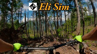
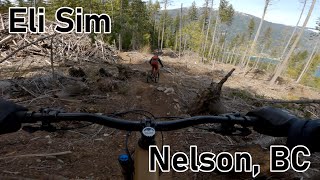
A popular choice despite getting roughed-in over the years because of faster, less-technical riding with stunts on the side, and the only true top-to-bottom trail built on this aspect.

Local Trail Association
More Stats for Eli Sim mountain bike trail trail
  • Altitude change
    -1,086 ft
  • Altitude min
    2,390 ft
  • Altitude max
    3,476 ft
  • Altitude start
    3,476 ft
  • Altitude end
    2,388 ft
  • Grade
    -21.2%
  • Grade max
    -62.2%
  • Grade min
    -3.9%
  • Distance down
    5,115 ft
  • Avg time
    00:13:35
  • Avg reverse time
    00:04:23
  • view trail stats
Status:
on Nov 26, 2023
Ideal
Avg: 4.6 (23 votes)
Your vote: 0

view (1,034)
close
3D
Trail Conditions
  • Unknown
  • Snow Groomed
  • Snow Packed
  • Snow Covered
  • Snow Cover Inadequate
  • Freeze/thaw Cycle
  • Icy
  • Prevalent Mud
  • Wet
  • Variable
  • Ideal
  • Dry
  • Very Dry
Trail Flow (Ridden Direction)
Trailforks scans users ridelogs to determine the most popular direction each trail is ridden. A good flowing trail network will have most trails flowing in a single direction according to their intension.
The colour categories are based on what percentage of riders are riding a trail in its intended direction.
  • > 96%
  • > 90%
  • > 80%
  • > 70%
  • > 50%
  • < 50%
  • bi-directional trail
  • no data
Trail Last Ridden
Trailforks scans ridelogs to determine the last time a trail was ridden.
  • < 2 days
  • < 1 week
  • < 2 weeks
  • < 1 month
  • < 6 months
  • > 6 months
Trail Ridden Direction
The intended direction a trail should be ridden.
  • Downhill Only
  • Downhill Primary
  • Both Directions
  • Uphill Primary
  • Uphill Only
  • One Direction
Contribute Details
Colors indicate trail is missing specified detail.
  • Description
  • Photos
  • Description & Photos
  • Videos
Trail Popularity ?
Trailforks scans ridelogs to determine which trails are ridden the most in the last 9 months. Trails are compared with nearby trails in the same city region with a possible 25 colour shades. Think of this as a heatmap, more rides = more kinetic energy = warmer colors.
  • most popular
  • popular
  • less popular
  • not popular
ATV/ORV/OHV Filter
Max Vehicle Width
inches

Radar Time
x Activity Recordings
Trailforks users anonymized public ridelogs from the past 6 months.
  • mountain biking recent
  • mountain biking (>6 month)
  • hiking (1 year)
  • moto (1 year)
Activity Recordings
Trailforks users anonymized public skilogs from the past 12 months.
  • Downhill Ski
  • Backcountry Ski
  • Nordic Ski
  • Snowmobile
Winter Trails
Warning A routing network for winter maps does not exist. Selecting trails using the winter trails layer has been disabled.
x Missing Trails
Most Popular
Least Popular
Trails are colored based on popularity. The more popular a trail is, the more red. Less popular trails trend towards green.
Jump Magnitude Heatmap
Heatmap of where riders jump on trails. Zoom in to see individual jumps, click circles to view jump details.
Trails Deemphasized
Trails are shown in grey.
disable
Only show trails with NO bikes.
enable

Save the current map location and zoom level as your default home location whenever this page is loaded.

Save
      Directions to eli-sim trailhead (49.492660, -117.260730)
      update trails status or condition

      Eli Sim Trail Reports

      statusdatedescription
      Nov 26, 2023 @ 5:37pm
      Nov 26, 2023
      Frozen and grippy. Like velcro.
      Nov 23, 2023 @ 6:53am
      Nov 23, 2023
      reporter Trails have reopened. Be aware of slash pile burning in progress on the Anderson Creek FSR. Spot closure of trails may be required.
      Nov 11, 2023 @ 10:57am
      Nov 11, 2023
      Tree is still down!
      Oct 6, 2023 @ 1:47pm
      Oct 6, 2023
      reporter
      Oct 1, 2023 @ 8:25pm
      Oct 1, 2023
      reporter
      view all reports »

      Recent Ridelog Activity on Trail

      Past Week
      • 2 rides
      • 5 miles avg distance
      6 Months
      • 127 rides
      • 7 miles avg distance
      All
      • 948 rides
      • Last: Nov 30, 2023

      Photos

      more »
      84 |
      Aug 5, 2022 @ 3:18pm
      Aug 5, 2022
      73 |
      Aug 5, 2022 @ 3:17pm
      Aug 5, 2022
      74 |
      May 13, 2022 @ 2:40pm
      May 13, 2022
      71 |
      May 13, 2022 @ 2:21pm
      May 13, 2022

      Trail Products

      8 Reviews & Comments


      We hope you've been enjoying Trailforks!

      Create a FREE account to view trail comments and much more.

      Videos

      more »
      Eli sim Trail  Mountain station  Nelson, BC
      9:14 | 564 | Feb 17, 2021 , Nelson
      Best Destination - Eli Sim
      10:38 | 250 | Jul 13, 2020 , Nelson
      Eli Sim Trail Preview
      5:32 | 585 | Jul 7, 2020 , Nelson
      youtuber Best Mountain Biking in Nelson, BC - Eli Sim Trail
      8:37 | 968 | Jul 19, 2018 , Nelson
      • By BCpov & contributors
      • #2295 - 7,278 views