


Open in App
Get this trail on your phone instantly.

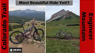
This popular trail is technical in a few sections mainly north of Pass Trail, but is very rideable and fun overall (especially south of Pass Trail). The views at the top are very nice
There are several different ways to access this trail, the easiest being from the top of Coal Bank Pass (10,600 ft.) via the Pass Creek trail. Once Pass Creek trail meets Engineer Mountain Trail, take a left and get ready for a fun descent after about half a mile. The downhill is only steep in a few locations; it contains plenty of roots and switchbacks, but only a few rock gardens (no big mandatory moves). This option is typically done with a shuttle vehicle at the bottom of the trail (or hitchhike back up).
Alternatively, you can ride the Colorado Trail from Molas Pass and link up with the EMT. This is a high alpine ride which also is typically done with a shuttle (this option is strenuous, approx. 20 miles, with nearly 3,000 feet of climbing, most of which is done above 11,000 feet.). Upon reaching EMT from Molas Pass Trail, there is a short but steep and mildly shelfy descent (not recommended for beginners). Then the trail has a series of steep uphill grades, some are difficult to clean due to altitude, grade, and loose dirt. Eventually you'll pass Pass Trail on your left, and from there you have about a half a mile before the fun downhill.
Another option is to approach from the bottom for an out and back. This option is open earlier in the year. Climb until it gets wet/snowy and then turn around and enjoy the descent.
| c1 | c2 | c3 | c4 |
|---|---|---|---|
January | February | March | April |
May | June | July | August |
September | October | November | December |

Service Road Atlas is a free to use, community-driven service for viewing and creating reports on the numerous back-country service roads around B.C. and Alberta.
Save the current map location and zoom level as your default home location whenever this page is loaded.
SaveWe hope you've been enjoying Trailforks!
Create a FREE account to view trail comments and much more.
You must enter a description before submitting.

