more stats
3,868 ft
Distance
3 ft
Climb
-287 ft
Descent
00:08:17
Avg time
-284 ft
Altitude change
5,121 ft
Altitude min
5,408 ft
Altitude max
5,406 ft
Altitude start
5,121 ft
Altitude end
-7.4%
Grade
-24.1%
Grade max
5.3%
Grade min
135 ft
Distance climb
3,287 ft
Distance down
446 ft
Distance flat
00:08:17
Avg time

Trail Details

  • Activities
    • Mountain Bike
    • E-Bike
  • Riding Area
    Moose Mountain
    Bragg Creek, Alberta
  • Difficulty Rating
  • Local Popularity
    65 in Mountain Biking [+]
    • 95 in E-Biking
  • Global Ranking
    #55366 in Mountain Biking [+]
    • #14380 in E-Biking
  • Trail Type
    Machine Groomed
  • Bike Type
    DH, AM, DJ
  • Direction
    Downhill Only
    Popular Direction Shown
  • Physical Rating
    Moderate
  • Trail Visibility
    Always easy to follow
  • Season
    June - October
  • Dogs Allowed
    Yes
  • eBike Allowed
    Yes up to Class 1
  • TTFs on Trail
    Berm, Bridge, Drop, Jump, Gap Jump, Other
  • Year Opened
    2019

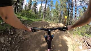
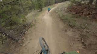
Advanced jump trail, gap features and Double Black rating throughout the first half. Second half is more inline with Single Black rating with optional bigger features.

Look before you leap. You won’t clear all of the jumps/gaps on the first ride through Please take a preview lap and get to know the trail before you start sending it. If you are new to the trail, do not follow someone that is also new into the jumps. Follow an experienced rider or take the time to look at everything first.

Please DO NOT roll over the lips. They’re all clean, crisp and work great at the moment. When you roll over the top of the jump, you damage the lip and ruin them. If you’re not comfortable hitting the jump, please ride around it. This is especially important with them being soft.

Access Info

Walk or ride up from the 2k parking lot up Sulphur Springs

Disclaimer

Gap jumps, ensure you look before riding

Trail Supporters
Local Trail Association

Recent Activity on Trail

Past Week
  • 0 rides
  •  
6 Months
  • 10 rides
  • 8 miles avg distance
All
  • 236 rides
  • Last: Jun 23, 2026
c1c2c3c4
January
February
March
April
May
June
July
August
September
October
November
December
update trails status or condition

Flight 66 -... Trail Reports

statusdatedescription
Jun 16, 2026 @ 8:50am (Pacific/Midway)
Jun 16, 2026
Dry and dusty in some parts
Nov 12, 2025 @ 7:02pm (America/Edmonton)
Nov 12, 2025
Sep 6, 2025 @ 8:34am
Sep 6, 2025
Aug 7, 2025 @ 8:57am
Aug 7, 2025
Upper section is in rough shape, tread is chewed up by heavy rain and hoofprints
May 11, 2025 @ 8:37pm
May 11, 2025
more »
Status:
on Jun 16, 2026
Variable
Avg: 4.33 (6 votes)
Your vote: 0

view (1,862)
close
3D
Trail Conditions
  • Unknown
  • Snow Groomed
  • Snow Packed
  • Snow Covered
  • Snow Cover Partial
  • Freeze/thaw Cycle
  • Icy
  • Prevalent Mud
  • Wet
  • Variable
  • Ideal
  • Dry
  • Very Dry
Trail Flow (Ridden Direction)
Trailforks scans users ridelogs to determine the most popular direction each trail is ridden. A good flowing trail network will have most trails flowing in a single direction according to their intension.
The colour categories are based on what percentage of riders are riding a trail in its intended direction.
  • > 96%
  • > 90%
  • > 80%
  • > 70%
  • > 50%
  • < 50%
  • bi-directional trail
  • no data
Trail Last Ridden
Trailforks scans ridelogs to determine the last time a trail was ridden.
  • < 2 days
  • < 1 week
  • < 2 weeks
  • < 1 month
  • < 6 months
  • > 6 months
Trail Ridden Direction
The intended direction a trail should be ridden.
  • Downhill Only
  • Downhill Primary
  • Both Directions
  • Uphill Primary
  • Uphill Only
  • One Direction
Contribute Details
Colors indicate trail is missing specified detail.
  • Description
  • Photos
  • Description & Photos
  • Videos
Trail Popularity ?
Trailforks scans ridelogs to determine which trails are ridden the most in the last 9 months. Trails are compared with nearby trails in the same city region with a possible 25 colour shades. Think of this as a heatmap, more rides = more kinetic energy = warmer colors.
  • most popular
  • popular
  • less popular
  • not popular
ATV/ORV/OHV Filter
Max Vehicle Width
inches
US Cell Coverage
Legend
cell carrier legend

Radar Time
Activity Recordings
Trailforks uses anonymized public activity data. ?
Activity Recordings
Trailforks uses anonymized public activity data. ?
Personal Heatmap
Activity Types
all / none
Options
2
Date range month
Winter Trails
Warning A routing network for winter maps does not exist. Selecting trails using the winter trails layer has been disabled.
Missing Trails
Most Popular
Least Popular
Trails are colored based on popularity. The more popular a trail is, the more red. Less popular trails trend towards green.
Jump Magnitude Heatmap
Heatmap of where riders jump on trails. Zoom in to see individual jumps, click circles to view jump details.
BC Backroad Status

Service Road Atlas is a free to use, community-driven service for viewing and creating reports on the numerous back-country service roads around B.C. and Alberta.

map legend
Slope Aspect
Direction the slope faces
Flat N NE E SE S SW W NW
Trails Deemphasized
Trails are shown in grey.
disable
Only show trails with no bike usage.
Enable
Suggested Layers
Based on selected activity type

    Save the current map location and zoom level as your default home location whenever this page is loaded.

    Save
        Directions to flight-66-upper-section trailhead (50.877250, -114.748730)

        Photos

        25 more »
        393 |
        Jun 14, 2023 @ 10:40pm
        Jun 14, 2023
        214 |
        Sep 30, 2022 @ 10:07pm
        Sep 30, 2022
        229 |
        Jul 8, 2022 @ 10:13pm
        Jul 8, 2022
        398 |
        Sep 30, 2021 @ 8:20pm
        Sep 30, 2021

        Videos

        11 more »
        youtuber The Best Mountain Bike Jump Trail in Alberta |...
        7:46 | 823 | Nov 1, 2023 , Bragg Creek
        Flight 66, Moose Mountain AB
        5:08 | 559 | Sep 12, 2022 , Bragg Creek
        Flight 66 Moose Mountain Alberta
        5:14 | 1494 | May 30, 2022 , Bragg Creek
        HOW TO DO JUMPS ON A BOWHEAD REACH ADAPTIVE E-MTB?
        7:52 | 530 | May 17, 2021 , Bragg Creek

        Routes with this trail

        20 miles 3,650 ft 3 Loop Race
        Enduro Race with the following timed stages: Stage 1: ROS Upper Stage 2: ROS Lower Stage 3: 727 Stage 4: A...
        20 miles 3,476 ft 4 Loop Race
        Enduro Race with the following timed stages: (pro stage optional, does not count towards single event...

        2 Reviews & Comments


        We hope you've been enjoying Trailforks!

        Create a FREE account to view trail comments and much more.

        • By MooseMountainTF Pro MMBTS & contributors
        • #207336 - 11,735 views

        Frequently Asked Questions About Flight 66 - Upper Section

        Where is Flight 66 - Upper Section located?
        Flight 66 - Upper Section is located in Moose Mountain, Bragg Creek, Alberta, Canada. It is part of the Moose Mountain trail network. The trailhead is located at coordinates 50.87725, -114.74873.
        How hard is Flight 66 - Upper Section?
        Flight 66 - Upper Section is rated as Double Black Diamond difficulty. The physical rating is Moderate. The average grade is 7.4%.
        What is the elevation gain for Flight 66 - Upper Section?
        Flight 66 - Upper Section has 1 m of elevation gain. The trail has 88 m of elevation descent. The elevation ranges from 1,561 m to 1,649 m.
        Is Flight 66 - Upper Section a point to point trail?
        Yes, Flight 66 - Upper Section is a point to point trail. The direction is Downhill Only. The trail type is machine groomed.

        Hit the Trail

        Open in App

        Get this trail on your phone instantly.
        open trail in app

        Download Trail

        Save to wishlist, Garmin & download.
        save the trail

        Find Related Routes

        Find routes and users activities that include this trail.
        find routes for this trail

        You must enter a description before submitting.