close
-
Layers w
- Weather Layers
- Pro
- Pro
- Pro
- Pro
- Pro
- Pro
- More Layers
- Pro
- Pro
- Pro
- Pro
-
Upgrade to

3D
Trail Conditions
- Unknown
- Snow Groomed
- Snow Packed
- Snow Covered
- Snow Cover Partial
- Freeze/thaw Cycle
- Icy
- Prevalent Mud
- Wet
- Variable
- Ideal
- Dry
- Very Dry
Trail Flow (Ridden Direction)
Trailforks scans users ridelogs to determine the most popular direction each trail is ridden. A good flowing trail network will have most trails flowing in a single direction according to their intension.
The colour categories are based on what percentage of riders are riding a trail in its intended direction.
The colour categories are based on what percentage of riders are riding a trail in its intended direction.
- > 96%
- > 90%
- > 80%
- > 70%
- > 50%
- < 50%
- bi-directional trail
- no data
Trail Last Ridden
Trailforks scans ridelogs to determine the last time a trail was ridden.
- < 2 days
- < 1 week
- < 2 weeks
- < 1 month
- < 6 months
- > 6 months
Trail Ridden Direction
The intended direction a trail should be ridden.
- Downhill Only
- Downhill Primary
- Both Directions
- Uphill Primary
- Uphill Only
- One Direction
Contribute Details
Colors indicate trail is missing specified detail.
- Description
- Photos
- Description & Photos
- Videos
Trail Popularity ?
Trailforks scans ridelogs to determine which trails are ridden the most in the last 9 months.
Trails are compared with nearby trails in the same city region with a possible 25 colour shades.
Think of this as a heatmap, more rides = more kinetic energy = warmer colors.
- most popular
- popular
- less popular
- not popular
ATV/ORV/OHV Filter
Max Vehicle Width
inches
US Cell Coverage
Legend

Radar Time
Activity Recordings
Trailforks uses anonymized public activity data.
?
Activity Recordings
Trailforks uses anonymized public activity data.
?
Personal Heatmap
▶
Activity Types
all
/
none
▶
Options
2
Date range
month
–
Winter Trails
Warning
A routing network for winter maps does not exist. Selecting trails using the winter trails layer has been disabled.
Missing Trails
Most Popular
Least Popular
Trails are colored based on popularity. The more popular a trail is, the more red. Less popular trails trend towards green.
Jump Magnitude Heatmap
Heatmap of where riders jump on trails. Zoom in to see individual jumps, click circles to view jump details.
BC Backroad Status
![map legend]()
Service Road Atlas is a free to use, community-driven service for viewing and creating reports on the numerous back-country service roads around B.C. and Alberta.

Slope Aspect
Direction the slope faces
Trails Deemphasized
Trails are shown in grey.
Only show trails with no bike usage.
Suggested Layers
Based on selected activity type
Save the current map location and zoom level as your default home location whenever this page is loaded.
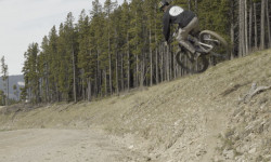
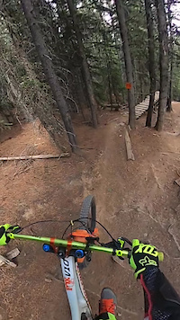
SaveA network for gravity oriented trails managed and maintained by the Moose Mountain Bike Trail Society and all its volunteers. From May 15th each year the trails are shuttle accessible with parking out of Ing Mine just west of the base of Moose Mountain road. Uphill pedal options are also available via Family Guy, Pneuma, and the road itself. All trails on the west side of the road ultimately end at Ing Mine while trails off the east side of the road end at Station Flats (east on Hwy 66).
Moose Trails are best navigated by confident riders looking to expand and enjoy their descending techniques. All trails have ride around options and there are no mandatory air features in the network.
Moose Trails are best navigated by confident riders looking to expand and enjoy their descending techniques. All trails have ride around options and there are no mandatory air features in the network.
Primary Trail Type: All-Mountain & Downhill
eBikes Allowed:
Yes
Shuttleable: YES
Land Status: Crown Land
 google parking directions
 Access Info:
Head west of Calgary and head towards Bragg Creek. Take Hwy 66 west of Bragg Creek, past Elbow Falls and stage out of either Station Flats or Ing mine parking lots.
Disclaimer:
Cell coverage is intermittent and mountain biking has its own risks. Ride smart and ride safe.
Links
Activities Click to view
- Mountain Bike
43 trails
- E-Bike
42 trails
- Hike
34 trails
- Trail Running
34 trails
- Snowshoe
6 trails
Region Details
- 5
- 4
- 11
- 10
- 4
Region Status
Open as of 2 daysStats
- Avg Trail Rating
- Trails (view details)
- 37
- Trails Mountain Bike
- 44
- Trails E-Bike
- 42
- Trails Hike
- 34
- Trails Trail Running
- 34
- Trails Snowshoe
- 6
- Total Distance
- 56 miles
- Total Descent
- 18,062 ft
- Total Vertical
- 3,044 ft
- Highest Trailhead
- 7,793 ft
- Reports
- 2,470
- Photos
- 1,290
- Ridden Counter
- 44,005
Articles
Video: Self-Shot Hot Laps on Some Of Alberta's Finest in 'Moosen'
May 28, 2026 from pinkbike.com
Bow Cycle's media creator takes a tripod and a custom Giant Reign Advanced E+2 out to Alberta's premium network to stack high-speed solo clips.

Race Report: Dust, Taquitos & A Whole Lot of Heart at MooseDuro 2025
Sep 15, 2025 from pinkbike.com
Rocky trails, great vibes, and a whole lot of two-wheel fun capped off another epic event.

Video: Hannah Gillcrist Shreds Puma Grande in Alberta, Canada
Sep 18, 2024 from pinkbike.com
The future is bright for this U21 racer.

Video: Park-Like Flow On A Community Funded Jump Trail in Alberta
Feb 25, 2024 from pinkbike.com
Local ripper Aiden Greanya finds flow at the otherwise notoriously janky Moose Mountain.
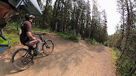
Popular Moose Mountain Mountain Biking Trails
• 100 ★ 4.4 • 2 miles • 0 ft • 3,359 •
The name is pronounced “7 of 27 Descent” and is inspired by the unique well identifier for the Shell 7 of 27 well site. The well is located in Legal Sub-Division 7 of Section 27 Township 22 Range 6 west of the 5th Meridian. (near...
• 90 ★ 4.5 • 3 miles • 79 ft • 2,151 •
One of the O.G. DH trails on Moose, RoS has seen plenty of changes over the years. The main line down is a blue DH descent with ride-arounds for everything. If it's your first time down in a while, definitely look before you leap, as...
• 85 ★ 4.0 • 3 miles • 22 ft • 1,983 •
A Blue level Downhill trail that is one of the longest in the system. Due to its western exposure it is one of the first trails to dry out in the System area every year. There are a few optional jumps and some rocky sections, but the...
• 85 ★ 4.1 • 2 miles • 16 ft • 1,798 •
stands for Super Happy Awesome Fun Trail. It is a high-speed bermed-corner blue trail that has become popular with the XC/AM crowd as well. starts off fairly mellow with some sweeping corners and little hits here and there. As it rolls...
• 95 ★ 4.7 • 735 ft • 0 ft • 1,776 •
Originally meant to replace the drainage exit, however the final section eroded to the point that it was too difficult to maintain a Blue rating. So it is now a fitting end to the black trail .
• 85 ★ 4.2 • 6 miles • 1,916 ft • 1,709 •
This is the climbing route to access the s without having to use the . This trail has lots of technically challenging climbing with steep switchbacks, roots, and rocks to deal with. You could also ride down this trail, but it does not...
• 95 ★ 4.3 • 2 miles • 246 ft • 1,644 •
A flow trail with jumps of varying size, berms, boardwalks and +/- 110m of climbing. This trail is primarily for riders from and Sulpher Springs to access the parking lot. There are 2 climbs on this trail and for your efforts you are...
• 95 ★ 4.0 • 1,093 ft • 8 ft • 1,421 •
Alternate route on way to parking lot to get 1 more hill in, consists of single track & wider trail. Runs beside Sulphur Springs in forest, crosses Elbow Valley, then turns and reconnect to Elbow Valley. Short hill climb is the only...
Moose Mountain Mountain Bike Routes
★ 4.0 • 13 miles • 2,351 ft • 6 • Loop •
Go all the way up to the end of . Take the access road down to where it meets up with . The end of meets...
12 miles • 2,467 ft • 4 •
Stage from Ings, Out Up RoS in two stages Up RoH Down Back via Canyon Creek
★ 4.0 • 54 miles • 7,238 ft • 15 • Loop •
This is a classic 1990s Epic Cross country ride and is recommended for fit riders only. For a time, the...
13 miles • 2,591 ft • 8 • Loop •
/ /727 Loop from lower parking lot (not Station Flats)
★ 4.0 • 11 miles • 1,991 ft • 17 • Loop •
Moose mtn - 7-27 loop
10 miles • 1,739 ft • 2 • Loop •
Route for map overview of corporate sponsored trail day.
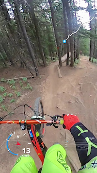
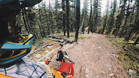
Photos of Moose Mountain Mountain Bike
Videos of Moose Mountain Mountain Bike
trail: 1 Mo' Hill
0:26 |
49 |
Aug 8, 2024
trail: T-Dub
7:12 |
160 |
Aug 7, 2024
trail: SHAFT
0:44 |
54 |
Jul 9, 2024
trail: Moose Mountain Trail
0:47 |
230 |
Mar 6, 2024
trail: Flight 66 - Upper Section
0:15 |
235 |
Jan 30, 2024
trail: Race of Spades
0:16 |
|
Jul 21, 2023
trail: T-Dub
0:07 |
92 |
May 26, 2023
trail: T-Dub
0:39 |
147 |
May 25, 2023
Current Trail Warnings
| status | trail | date | condition | user | info |
|---|---|---|---|---|---|
| Special K | Jul 11, 2026 @ 2:43pm (America/Edmonton) 2 days | Unknown | yyc-barbarian | Trail is closed as of July 5th, 2026. |
Recent Trail Reports
| status | trail | date | condition | info | user |
|---|---|---|---|---|---|
| Moose Mountain Trail | Jul 11, 2026 @ 4:52pm (America/Edmonton) 2 days | Ideal | SilverFox24 | ||
| SHAFT | Jul 11, 2026 @ 4:49pm (America/Edmonton) 2 days | Ideal | SilverFox24 | ||
| Prairie Mountain Shoulder Road | Jul 11, 2026 @ 10:36am (America/Creston) 2 days | Dry | mountainmaneuvers | ||
| Moose Mountain Road | Jul 11, 2026 @ 10:36am (America/Creston) 2 days | Ideal | mountainmaneuvers | ||
| Canyon Creek Road | Jul 11, 2026 @ 10:36am (America/Creston) 2 days | Ideal | mountainmaneuvers | ||
| Rampage | Jul 11, 2026 @ 10:36am (America/Creston) 2 days | Dry | mountainmaneuvers | ||
| T-Dub | Jul 11, 2026 @ 10:36am (America/Creston) 2 days | Ideal | mountainmaneuvers | ||
| Shattered | Jul 11, 2026 @ 10:36am (America/Creston) 2 days | Variable | mountainmaneuvers | ||
| Race of Hearts | Jul 9, 2026 @ 9:06am (America/Edmonton) Jul 9, 2026 | Variable | MLVN | ||
| Race of Spades | Jul 9, 2026 @ 9:04am (America/Edmonton) Jul 9, 2026 | Ideal | MLVN |
Activity Feed
| username | action | type | title | date |
|---|---|---|---|---|
| dilusion56 | add | karma | activity #99086656 | Jul 13, 2026 @ 3:21am 10 hours |
| Bogusia | ridden | trail | activity #99033131 and 1 more | Jul 12, 2026 @ 9:53am 1 day |
| Zemu | add | video | activity #99028492 | Jul 12, 2026 @ 9:10am 1 day |
| Jesse0cDJLE | wishlist | trail | activity #98987094 and 1 more | Jul 11, 2026 @ 7:30pm 2 days |
| Rtdeadrock | ridden | trail | activity #98985960 and 1 more | Jul 11, 2026 @ 6:59pm 2 days |
Recent Comments
| username | type | title | comment | date |
|---|---|---|---|---|
| trail | I love Family Guy for all the natural beauty... | Jul 8, 2026 @ 8:44am Jul 8, 2026 | ||
| trail | Bike approach is possible to the false summit... | Jul 8, 2026 @ 8:17am Jul 8, 2026 | ||
| trail | Bunch of trees down 5 minutes above Race of... | Jun 6, 2026 @ 5:27pm Jun 6, 2026 | ||
| report | Upper flight is in good condition, lower... | Jun 6, 2026 @ 1:39pm Jun 6, 2026 | ||
| trail | I’d describe this trail as (violin music... | Jun 6, 2026 @ 8:00am Jun 6, 2026 |
Nearby Areas
| name | distance | ||||
|---|---|---|---|---|---|
| Prairie Mountain | 1 | 6 | 5 | 3 | 3.2 km |
| West Bragg Creek | 13 | 32 | 1 | 3.6 km | |
| Station Flats | 2 | 10 | 4.3 km | ||
| Jumpingpound Ridge | 1 | 7 | 6 | 7 km | |
| Jumpingpound Creek | 6 | 7.4 km |
Local Badges
-

Completionist13 awarded
Activity Type Stats
| activitytype | trails | distance | descent | descent distance | total vertical | rating | global rank | state rank | photos | reports | routes | ridelogs |
|---|---|---|---|---|---|---|---|---|---|---|---|---|
| Mountain Bike | 43 | 51 miles | 16,864 ft | 26 miles | 3,045 ft | #260 | #8 | 1,273 | 2,484 | 27 | 41,487 | |
| E-Bike | 42 | 49 miles | 16,539 ft | 25 miles | 3,015 ft | #851 | #14 | 14 | 2,460 | 7 | 2,786 | |
| Hike | 34 | 42 miles | 8,458 ft | 16 miles | 3,045 ft | #447 | #7 | 3 | 2,198 | 336 | ||
| Trail Running | 34 | 42 miles | 8,458 ft | 16 miles | 3,045 ft | #2,189 | #19 | 2,202 | 248 | |||
| Snowshoe | 6 | 5 miles | 1,201 ft | 3 miles | 1,870 ft | #214 | #4 | 23 | 4 |
Frequently Asked Questions About Moose Mountain
▼
What are the highest rated mountain biking trails in Moose Mountain?
The highest rated mountain biking trails in Moose Mountain are:
- T-Dub (4.6/5)
- Jean Guy on The Rocks (4.6/5)
- Shattered (4.4/5)
- Race of Spades (4.4/5)
- 7-27 (4.3/5)
▼
What is the best time of the year to ride in Moose Mountain?
Based on ride log data, the most popular months to ride in Moose Mountain are:
- July (583 activities)
- August (449 activities)
- September (440 activities)
▼
Where can I park to ride in Moose Mountain?
There are 7 parking locations listed in Moose Mountain. The most popular parking spots are:
- Ing's Mine Parking
- Moose Mountain Road [Base] Parking
- 7-27 Parking
- 2K parking - Moose Mountain
- Station Flats Parking
▼
What is the longest trail in Moose Mountain?
The longest trail in Moose Mountain is Pneuma at 10.3 km. View all trails sorted by distance.
Activities
Trails
- By brenthillier
 NSMBA TRAILFORKS & contributors
 - Admins: BCT, MMBTS
- #3582 - 147,036 views
- moose mountain activity log | embed map of Moose Mountain mountain bike trails | moose mountain mountain biking points of interest
Downloading of trail gps tracks in kml & gpx formats is enabled for Moose Mountain.
You must login to download files.