more stats
4,006 ft
Distance
28 ft
Climb
-279 ft
Descent
00:02:37
Avg time
-252 ft
Altitude change
738 ft
Altitude min
990 ft
Altitude max
990 ft
Altitude start
738 ft
Altitude end
-6.3%
Grade
-30.5%
Grade max
13%
Grade min
525 ft
Distance climb
2,566 ft
Distance down
860 ft
Distance flat
00:02:37
Avg time

Flow K Details

  • Activities
    • Mountain Bike
    • E-Bike
    • Gravel Bike
    • Hike
    • Trail Running
  • Riding Area
  • Difficulty Rating
  • Local Popularity
    65 in Mountain Biking [+]
    • 90 in E-Biking
    • 5 in Trail Running
    • 5 in Hiking
  • Global Ranking
    #87600 in Mountain Biking [+]
    • #23319 in E-Biking
    • #132550 in Trail Running
    • #125871 in Hiking
  • Hiking SAC Scale
    T1 Hiking
  • Trail Type
    Singletrack
  • Bike Type
    DH, AM, XC, Gravel
  • Direction
    Downhill Only[+]
    Popular Direction Shown
    • Downhill Only for E-Biking
    • Downhill Only for Trail Running
    • Downhill Only for Hiking
    • Downhill Only for Gravel Biking
  • Climb Difficulty
    Blue
  • Physical Rating
    Moderate
  • Trail Visibility
    Always easy to follow
  • Dogs Allowed
    Yes
  • eBike Allowed
    Yes up to Class 1
  • TTFs on Trail
    Berm, Drop, Jump
  • Land Owner
    Greater Wellington Regional Council (GWRC)

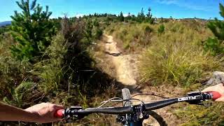
The completely re-built Flow K. Starts by traversing along the side of the hill with a few ups and downs and some steep switchback climbs before heading all the way to the bottom.

Local Trail Association

Recent Activity on Trail

Past Week
  • 0 rides
  •  
6 Months
  • 4 rides
  • 10 miles avg distance
All
  • 79 rides
  • Last: Jun 12, 2026
c1c2c3c4
January
February
March
April
May
June
July
August
September
October
November
December
update trails status or condition

Flow K Trail Reports

statusdatedescription
Jun 13, 2026 @ 6:03pm (Pacific/Auckland)
Jun 12, 2026
Trail still closed for rebuild work. Please stay off this trail until it is officially reopened. The new surface needs time to bed in and there is...
Jun 4, 2026 @ 8:19am (Pacific/Auckland)
Jun 3, 2026
Closed for maintenance at present.
May 31, 2026 @ 3:10pm (Pacific/Auckland)
May 30, 2026
Mar 21, 2026 @ 3:55pm (Pacific/Auckland)
Mar 20, 2026
Mar 21, 2026 @ 3:55pm (Pacific/Auckland)
Mar 20, 2026
more »
Status:
on Jun 13, 2026
Variable
Avg: 3.74 (2 votes)
Your vote: 0

view (1,069)
close
3D
Trail Conditions
  • Unknown
  • Snow Groomed
  • Snow Packed
  • Snow Covered
  • Snow Cover Partial
  • Freeze/thaw Cycle
  • Icy
  • Prevalent Mud
  • Wet
  • Variable
  • Ideal
  • Dry
  • Very Dry
Trail Flow (Ridden Direction)
Trailforks scans users ridelogs to determine the most popular direction each trail is ridden. A good flowing trail network will have most trails flowing in a single direction according to their intension.
The colour categories are based on what percentage of riders are riding a trail in its intended direction.
  • > 96%
  • > 90%
  • > 80%
  • > 70%
  • > 50%
  • < 50%
  • bi-directional trail
  • no data
Trail Last Ridden
Trailforks scans ridelogs to determine the last time a trail was ridden.
  • < 2 days
  • < 1 week
  • < 2 weeks
  • < 1 month
  • < 6 months
  • > 6 months
Trail Ridden Direction
The intended direction a trail should be ridden.
  • Downhill Only
  • Downhill Primary
  • Both Directions
  • Uphill Primary
  • Uphill Only
  • One Direction
Contribute Details
Colors indicate trail is missing specified detail.
  • Description
  • Photos
  • Description & Photos
  • Videos
Trail Popularity ?
Trailforks scans ridelogs to determine which trails are ridden the most in the last 9 months. Trails are compared with nearby trails in the same city region with a possible 25 colour shades. Think of this as a heatmap, more rides = more kinetic energy = warmer colors.
  • most popular
  • popular
  • less popular
  • not popular
ATV/ORV/OHV Filter
Max Vehicle Width
inches
US Cell Coverage
Legend
cell carrier legend

Radar Time
Activity Recordings
Trailforks uses anonymized public activity data. ?
Activity Recordings
Trailforks uses anonymized public activity data. ?
Personal Heatmap
Activity Types
all / none
Options
2
Date range month
Winter Trails
Warning A routing network for winter maps does not exist. Selecting trails using the winter trails layer has been disabled.
Missing Trails
Most Popular
Least Popular
Trails are colored based on popularity. The more popular a trail is, the more red. Less popular trails trend towards green.
Jump Magnitude Heatmap
Heatmap of where riders jump on trails. Zoom in to see individual jumps, click circles to view jump details.
BC Backroad Status

Service Road Atlas is a free to use, community-driven service for viewing and creating reports on the numerous back-country service roads around B.C. and Alberta.

map legend
Slope Aspect
Direction the slope faces
Flat N NE E SE S SW W NW
Trails Deemphasized
Trails are shown in grey.
disable
Only show trails with no bike usage.
Enable
Suggested Layers
Based on selected activity type

    Save the current map location and zoom level as your default home location whenever this page is loaded.

    Save
        Directions to flow-k trailhead (-41.084770, 175.160870)

        Photos

        4 more »
        86 |
        Nov 27, 2020 @ 4:36pm
        Nov 27, 2020
        86 |
        Nov 27, 2020 @ 3:28pm
        Nov 27, 2020
        67 |
        Nov 27, 2020 @ 3:28pm
        Nov 27, 2020
        93 |
        Mar 30, 2020 @ 10:56pm
        Mar 30, 2020

        Videos

        2 more »
        youtuber FLOW K @ Tunnel Gully. Upper Hutt
        2:21 | 494 | Mar 6, 2023 , Upper Hutt
        youtuber Half Flow @ Tunnel Gully. Upper Hutt
        2:10 | 431 | Jul 5, 2022 , Upper Hutt
        youtuber The Wolf/Half Flow @ Tunnel Gully
        2:07 | 595 | Oct 21, 2018 , Upper Hutt
        MTB Trail Flow K (Half Flow) Tunnel Gully -...
        4:38 | 603 | Feb 5, 2019 , Upper Hutt

        Routes with this trail

        TGE - Stage 2 Archived
        3,993 ft 30 ft 2 Race
        Stage 2 of the Tunnel Gully Enduro 2020
        8 miles 1,300 ft 14 Race
        Intermediate course of the Tunnel Gully Enduro 2020

        1 Review & Comments


        We hope you've been enjoying Trailforks!

        Create a FREE account to view trail comments and much more.

        • By Wookieetron5000TF Pro NtrailZ TGBT & contributors
        • #131502 - 3,433 views

        Frequently Asked Questions About Flow K

        Where is Flow K located?
        Flow K is located in Kaitoke Regional Park, Upper Hutt, New Zealand. It is part of the Kaitoke Regional Park trail network. The trailhead is located at coordinates -41.08477, 175.16087.
        How hard is Flow K?
        Flow K is rated as Advanced difficulty. The physical rating is Moderate. The average grade is 6.3%. The climb difficulty is rated Blue.
        What is the elevation gain for Flow K?
        Flow K has 8 m of elevation gain. The trail has 85 m of elevation descent. The elevation ranges from 225 m to 302 m.
        Is Flow K a point to point trail?
        Yes, Flow K is a point to point trail. The direction is Downhill Only. The trail type is singletrack.

        Hit the Trail

        Open in App

        Get this trail on your phone instantly.
        open trail in app

        Download Trail

        Save to wishlist, Garmin & download.
        save the trail

        Find Related Routes

        Find routes and users activities that include this trail.
        find routes for this trail

        You must enter a description before submitting.