more stats
3,760 ft
Distance
50 ft
Climb
-287 ft
Descent
00:08:00
Avg time
-238 ft
Altitude change
1,704 ft
Altitude min
1,977 ft
Altitude max
1,942 ft
Altitude start
1,703 ft
Altitude end
-6.3%
Grade
-30.8%
Grade max
34.1%
Grade min
600 ft
Distance climb
2,510 ft
Distance down
650 ft
Distance flat
00:08:00
Avg time

Flow Motion Details

  • Activities
    • Mountain Bike
    • Trail Running
  • Riding Area
    Sandy Ridge
    Sandy, Oregon
  • Difficulty Rating
  • Voted Difficulty
    Blue (1 vote)
  • Local Popularity
    95 in Mountain Biking [+]
    • 80 in Trail Running
  • Global Ranking
    #26988 in Mountain Biking [+]
    • #46200 in Trail Running
  • Trail Type
    Singletrack
  • Bike Type
    DH, AM
  • Physical Rating
    Moderate
  • Dogs Allowed
    Yes
  • Year Opened
    2013
  • Land Owner

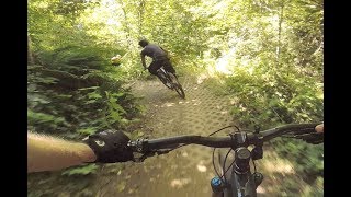
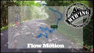
Flow Motion is one of the newest trails at Sandy Ridge. It connects to Follow the Leader and features an abundance of flow with endless berms and rollers the whole way through.

Flow Motion can be included in a bigger ride with Follow the Leader or a session route with Homestead Road.

Trail Supporters
Local Trail Association
Traditionally Indigenous Territory

Recent Activity on Trail

Past Week
  • 17 rides
  • 18 miles average
6 Months
  • 258 rides
  • 13 miles avg distance
All
  • 2,854 rides
  • Last: Jun 13, 2026
c1c2c3c4
January
February
March
April
May
June
July
August
September
October
November
December
update trails status or condition

Flow Motion Trail Reports

Status:
on Jun 13, 2026
Ideal
Avg: 4.3 (38 votes)
Your vote: 0

view (16,233)
close
3D
Trail Conditions
  • Unknown
  • Snow Groomed
  • Snow Packed
  • Snow Covered
  • Snow Cover Partial
  • Freeze/thaw Cycle
  • Icy
  • Prevalent Mud
  • Wet
  • Variable
  • Ideal
  • Dry
  • Very Dry
Trail Flow (Ridden Direction)
Trailforks scans users ridelogs to determine the most popular direction each trail is ridden. A good flowing trail network will have most trails flowing in a single direction according to their intension.
The colour categories are based on what percentage of riders are riding a trail in its intended direction.
  • > 96%
  • > 90%
  • > 80%
  • > 70%
  • > 50%
  • < 50%
  • bi-directional trail
  • no data
Trail Last Ridden
Trailforks scans ridelogs to determine the last time a trail was ridden.
  • < 2 days
  • < 1 week
  • < 2 weeks
  • < 1 month
  • < 6 months
  • > 6 months
Trail Ridden Direction
The intended direction a trail should be ridden.
  • Downhill Only
  • Downhill Primary
  • Both Directions
  • Uphill Primary
  • Uphill Only
  • One Direction
Contribute Details
Colors indicate trail is missing specified detail.
  • Description
  • Photos
  • Description & Photos
  • Videos
Trail Popularity ?
Trailforks scans ridelogs to determine which trails are ridden the most in the last 9 months. Trails are compared with nearby trails in the same city region with a possible 25 colour shades. Think of this as a heatmap, more rides = more kinetic energy = warmer colors.
  • most popular
  • popular
  • less popular
  • not popular
ATV/ORV/OHV Filter
Max Vehicle Width
inches
US Cell Coverage
Legend
cell carrier legend

Radar Time
Activity Recordings
Trailforks uses anonymized public activity data. ?
Activity Recordings
Trailforks uses anonymized public activity data. ?
Personal Heatmap
Activity Types
all / none
Options
2
Date range month
Winter Trails
Warning A routing network for winter maps does not exist. Selecting trails using the winter trails layer has been disabled.
Missing Trails
Most Popular
Least Popular
Trails are colored based on popularity. The more popular a trail is, the more red. Less popular trails trend towards green.
Jump Magnitude Heatmap
Heatmap of where riders jump on trails. Zoom in to see individual jumps, click circles to view jump details.
BC Backroad Status

Service Road Atlas is a free to use, community-driven service for viewing and creating reports on the numerous back-country service roads around B.C. and Alberta.

map legend
Slope Aspect
Direction the slope faces
Flat N NE E SE S SW W NW
Trails Deemphasized
Trails are shown in grey.
disable
Only show trails with no bike usage.
Enable
Suggested Layers
Based on selected activity type

    Save the current map location and zoom level as your default home location whenever this page is loaded.

    Save
        Directions to flow-motion trailhead (45.392930, -122.013350)

        Photos

        18 more »
        375 |
        Apr 13, 2017 @ 7:49pm
        Apr 13, 2017
        38 |
        Oct 17, 2025 @ 5:14pm
        Oct 17, 2025
        55 |
        Feb 1, 2024 @ 3:51pm
        Feb 1, 2024
        169 |
        Oct 18, 2021 @ 9:51am
        Oct 18, 2021

        Videos

        21 more »
        youtuber Flow Motion Trail into Lower Hide & Seek...
        12:12 | 1198 | Sep 17, 2018 , Sandy
        youtuber Flow Motion
        0:58 | 618 | Apr 29, 2020 , Sandy
        youtuber Flow Motion 2019 (Sandy Ridge, OR) Mountain Biking
        3:57 | 865 | Jul 20, 2019 , Sandy
        MTB Sandy Ridge, Oregon - Flowmotion (Sept 2025)
        4:47 | 121 | Sep 8, 2025 , Sandy

        Routes with this trail

        5.0 5 miles 874 ft 13
        LOC MTB Medium route for August 10th, 2019 Team ride. Up Homestead to , Down , across Homestead to , Down...
        5 miles 918 ft 4 Loop
        evo Trailgate Sandy Ridge Women's & Intermediate Group Ride Route 2025
        10 miles 1,883 ft 6
        Hard To Climb Hard Downhill

        5 Reviews & Comments


        We hope you've been enjoying Trailforks!

        Create a FREE account to view trail comments and much more.

        • By jerschwabTF Pro & contributors
        • #32138 - 8,752 views

        Frequently Asked Questions About Flow Motion

        Where is Flow Motion located?
        Flow Motion is located in Sandy Ridge, Sandy, Oregon, United States. It is part of the Sandy Ridge trail network. The trailhead is located at coordinates 45.39293, -122.01335.
        How hard is Flow Motion?
        Flow Motion is rated as Blue difficulty. The physical rating is Moderate. The average grade is 6.3%.
        What is the elevation gain for Flow Motion?
        Flow Motion has 50 ft of elevation gain. The trail has 287 ft of elevation descent. The elevation ranges from 1,704 ft to 1,977 ft.
        How long is Flow Motion?
        Flow Motion is 3,760 ft long. The trail type is singletrack.

        Hit the Trail

        Open in App

        Get this trail on your phone instantly.
        open trail in app

        Download Trail

        Save to wishlist, Garmin & download.
        save the trail

        Find Related Routes

        Find routes and users activities that include this trail.
        find routes for this trail

        You must enter a description before submitting.