more stats
2.0 miles
Distance
280 ft
Climb
-710 ft
Descent
00:19:19
Avg time
-430 ft
Altitude change
2,208 ft
Altitude min
2,744 ft
Altitude max
2,684 ft
Altitude start
2,254 ft
Altitude end
-4.1%
Grade
-38.8%
Grade max
60.9%
Grade min
2,283 ft
Distance climb
1 mile
Distance down
2,326 ft
Distance flat
00:19:19
Avg time

Forkbeard Details

  • Activities
    • Mountain Bike
    • E-Bike
  • Riding Area
  • Difficulty Rating
  • Local Popularity
    95 in Mountain Biking [+]
    • 80 in E-Biking
  • Global Ranking
    #6122 in Mountain Biking [+]
    • #43206 in E-Biking
  • Trail Type
    Singletrack
  • Bike Type
    AM, XC
  • Physical Rating
    Easy
  • Trail Visibility
    Always easy to follow
  • Season
    June-Oct
  • Dogs Allowed
    Yes
  • eBike Allowed
    Yes up to Class 1
  • TTFs on Trail
    Berm, Drop, Jump, Gap Jump, Rock Face, Rock Garden
  • Ride in Rain
    Yes
  • Year Opened
    2021

Norsk (English below):
En herlig morsom flytsti med doseringer og godt driv hele veien – men også tekniske elementer for de mer erfarne syklistene. Overflaten består av en blanding av stedlig jord og tilkjørt grus, noe som gir godt feste og jevn flyt.

Langs stien finnes flere utsiktspunkter med panoramautsikt mot Hallingdal, Vassfaret og innsjøen Krøderen. Underveis passerer du også en rasteplass med mulighet for bål (NB Bål er forbudt i perioden 15. april–15. september).

Stien starter øst for Høgevarde Fjellpark, like ved Lavvostien. Turen kan gjerne starte ved Lavvoen – følg Lavvostien til østre punkt, og ta derfra inn på Forkbeard.

English:
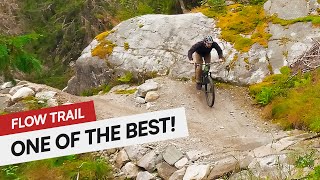
A wonderfully fun flowtrail with berms and great rhythm from start to finish – but also technical elements to challenge advanced riders. The surface is a mix of local dirt and imported gravel, giving solid grip and smooth flow.

Along the trail, you'll find several viewpoints with sweeping views of Hallingdal, Vassfaret, and Lake Krøderen. There is also a rest area with a fire pit along the way (NOTE: Campfires are not allowed during the forest fire season from April 15 to September 15).

The trail begins just east of Høgevarde Fjellpark, near Lavvostien. A great option is to start at the lavvu, ride Lavvostien to its easternmost point, and join Forkbeard from there.

Local Trail Association

Recent Activity on Trail

Past Week
  • 0 rides
  •  
6 Months
  • 0 rides
  •  
All
  • 16 rides
  • Last: Oct 9, 2025
c1c2c3c4
January
February
March
April
May
June
July
August
September
October
November
December
update trails status or condition

Forkbeard Trail Reports

statusdatedescription
Aug 9, 2024 @ 12:26pm
Aug 9, 2024
more »
Status:
on Aug 9, 2024
Wet
Avg: 4.13 (1 votes)
Your vote: 0

view (173)
close
3D
Trail Conditions
  • Unknown
  • Snow Groomed
  • Snow Packed
  • Snow Covered
  • Snow Cover Partial
  • Freeze/thaw Cycle
  • Icy
  • Prevalent Mud
  • Wet
  • Variable
  • Ideal
  • Dry
  • Very Dry
Trail Flow (Ridden Direction)
Trailforks scans users ridelogs to determine the most popular direction each trail is ridden. A good flowing trail network will have most trails flowing in a single direction according to their intension.
The colour categories are based on what percentage of riders are riding a trail in its intended direction.
  • > 96%
  • > 90%
  • > 80%
  • > 70%
  • > 50%
  • < 50%
  • bi-directional trail
  • no data
Trail Last Ridden
Trailforks scans ridelogs to determine the last time a trail was ridden.
  • < 2 days
  • < 1 week
  • < 2 weeks
  • < 1 month
  • < 6 months
  • > 6 months
Trail Ridden Direction
The intended direction a trail should be ridden.
  • Downhill Only
  • Downhill Primary
  • Both Directions
  • Uphill Primary
  • Uphill Only
  • One Direction
Contribute Details
Colors indicate trail is missing specified detail.
  • Description
  • Photos
  • Description & Photos
  • Videos
Trail Popularity ?
Trailforks scans ridelogs to determine which trails are ridden the most in the last 9 months. Trails are compared with nearby trails in the same city region with a possible 25 colour shades. Think of this as a heatmap, more rides = more kinetic energy = warmer colors.
  • most popular
  • popular
  • less popular
  • not popular
ATV/ORV/OHV Filter
Max Vehicle Width
inches
US Cell Coverage
Legend
cell carrier legend

Radar Time
Activity Recordings
Trailforks uses anonymized public activity data. ?
Activity Recordings
Trailforks uses anonymized public activity data. ?
Personal Heatmap
Activity Types
all / none
Options
2
Date range month
Winter Trails
Warning A routing network for winter maps does not exist. Selecting trails using the winter trails layer has been disabled.
Missing Trails
Most Popular
Least Popular
Trails are colored based on popularity. The more popular a trail is, the more red. Less popular trails trend towards green.
Jump Magnitude Heatmap
Heatmap of where riders jump on trails. Zoom in to see individual jumps, click circles to view jump details.
BC Backroad Status

Service Road Atlas is a free to use, community-driven service for viewing and creating reports on the numerous back-country service roads around B.C. and Alberta.

map legend
Slope Aspect
Direction the slope faces
Flat N NE E SE S SW W NW
Trails Deemphasized
Trails are shown in grey.
disable
Only show trails with no bike usage.
Enable
Suggested Layers
Based on selected activity type

    Save the current map location and zoom level as your default home location whenever this page is loaded.

    Save
        Directions to forkbeard trailhead (60.341760, 9.511270)

        Photos

        4 more »
        79 |
        Jun 22, 2023 @ 5:56am
        Jun 22, 2023
        60 |
        Jul 2, 2024 @ 1:58pm
        Jul 2, 2024
        75 |
        Jun 22, 2023 @ 5:56am
        Jun 22, 2023
        61 |
        Jun 22, 2023 @ 5:56am
        Jun 22, 2023

        Videos

        2 more »
        Trail preview - Forkbeard, Høgevarde, Hallingdal
        0:00 | 104 | Mar 21, 2025 , My City
        Forkbeard | TRAIL PREVIEW | Høgevarde, Norway...
        6:15 | 94 | Dec 1, 2024 , My City

        Reviews / Comments

        No reviews yet, be the first to write a review or ask a question.
        Use trail reports to comment on trail conditions.


        We hope you've been enjoying Trailforks!

        Create a FREE account to view trail comments and much more.

        • By Haraldh2002 & contributors
        • #578465 - 403 views

        Frequently Asked Questions About Forkbeard

        Where is Forkbeard located?
        Forkbeard is located in Høgevarde Trail Centre, Norway. It is part of the Høgevarde Trail Centre trail network. The trailhead is located at coordinates 60.34176, 9.51127.
        How hard is Forkbeard?
        Forkbeard is rated as Blue difficulty. The physical rating is Easy. The average grade is 4.1%.
        What is the elevation gain for Forkbeard?
        Forkbeard has 85 m of elevation gain. The trail has 216 m of elevation descent. The elevation ranges from 673 m to 836 m.
        How long is Forkbeard?
        Forkbeard is 3.2 km long. The trail type is singletrack.

        Hit the Trail

        Open in App

        Get this trail on your phone instantly.
        open trail in app

        Download Trail

        Save to wishlist, Garmin & download.
        save the trail

        Find Related Routes

        Find routes and users activities that include this trail.
        find routes for this trail

        You must enter a description before submitting.