1.1 miles
Distance
-690 ft
Descent
00:06:15
Avg time
Funny Bone (30) Details
-
Activities
- Mountain Bike
-
Riding AreaKillington Bike Park
Killington, Vermont -
Difficulty Rating
-
Voted DifficultyDouble Black Diamond (2 votes)
-
Trail TypeMixed
-
Bike TypeDH
-
DirectionDownhill OnlyPopular direction shown
-
Dogs AllowedYes
-
Global Ranking#79717 in Mountain Biking
-
Local Popularity25 in Mountain Biking
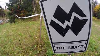
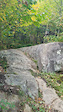
Most this trail is double track. It is a bit rocky and loose up at the top, then levels out with some nice views of the resort as you cross ski runs. Near the bottom you turn off the double track to hit the rock slabs that the trail is famous for. Then you continue on an old grassy service road where you can drop off onto The Beast Trail.
Traditionally Indigenous Territory
More Stats for Funny Bone (30) mountain bike trail trail
-
Altitude change-690 ft
-
Altitude min3,040 ft
-
Altitude max3,730 ft
-
Altitude start3,730 ft
-
Altitude end3,041 ft
-
Grade-12%
-
Grade max-57.9%
-
Grade min-3.7%
-
Distance down1 mile
-
Avg time00:06:15
- view trail stats
close
3D
Trail Conditions
- Unknown
- Snow Groomed
- Snow Packed
- Snow Covered
- Snow Cover Partial
- Freeze/thaw Cycle
- Icy
- Prevalent Mud
- Wet
- Variable
- Ideal
- Dry
- Very Dry
Trail Flow (Ridden Direction)
Trailforks scans users ridelogs to determine the most popular direction each trail is ridden. A good flowing trail network will have most trails flowing in a single direction according to their intension.
The colour categories are based on what percentage of riders are riding a trail in its intended direction.
- > 96%
- > 90%
- > 80%
- > 70%
- > 50%
- < 50%
- bi-directional trail
- no data
Trail Last Ridden
Trailforks scans ridelogs to determine the last time a trail was ridden.
- < 2 days
- < 1 week
- < 2 weeks
- < 1 month
- < 6 months
- > 6 months
Trail Ridden Direction
The intended direction a trail should be ridden.
- Downhill Only
- Downhill Primary
- Both Directions
- Uphill Primary
- Uphill Only
- One Direction
Contribute Details
Colors indicate trail is missing specified detail.
- Description
- Photos
- Description & Photos
- Videos
Trail Popularity ?
Trailforks scans ridelogs to determine which trails are ridden the most in the last 9 months.
Trails are compared with nearby trails in the same city region with a possible 25 colour shades.
Think of this as a heatmap, more rides = more kinetic energy = warmer colors.
- most popular
- popular
- less popular
- not popular
ATV/ORV/OHV Filter
Max Vehicle Width
inches
US Cell Coverage
Legend
Radar Time
x
Activity Recordings
Trailforks users anonymized public ridelogs from the past 6 months.
- mountain biking recent
- mountain biking (>6 month)
- hiking (1 year)
- moto (1 year)
Activity Recordings
Trailforks users anonymized public skilogs from the past 12 months.
- Downhill Ski
- Backcountry Ski
- Nordic Ski
- Snowmobile
Winter Trails
Warning
A routing network for winter maps does not exist. Selecting trails using the winter trails layer has been disabled.
x
Missing Trails
Most Popular
Least Popular
Trails are colored based on popularity. The more popular a trail is, the more red. Less popular trails trend towards green.
Jump Magnitude Heatmap
Heatmap of where riders jump on trails. Zoom in to see individual jumps, click circles to view jump details.
Trails Deemphasized
Trails are shown in grey.
Only show trails with NO bikes.
Save the current map location and zoom level as your default home location whenever this page is loaded.
Save
Directions to funny-bone-30 trailhead
(43.605890, -72.810140)
update trails status or condition
Funny Bone (30) Trail Reports
view all reports »
Recent Ridelog Activity on Trail
Past Week
- 0 rides
6 Months
- 6 rides
- 35 miles avg distance
All
- 109 rides
- Last: Mar 9, 2025
Photos
more »
We hope you've been enjoying Trailforks!
Create a FREE account to view trail comments and much more.
Videos
more »
youtuber

1663 |
Oct 16, 2017 , Killington
Nearby Trails
- Launch Pad 23 ft
- Breakaway 892 ft
- Cable Trail (18) 994 ft
- Anarchy 1,352 ft
- Solitude 1,421 ft
Killington Bike Park
- By StephaneMarceau
TRAILFORKS & contributors
- #44379 - 2,593 views
- follow/subscribe
- login to download gpx or kml files.
You must enter a description before submitting.