

Open in App
Get this trail on your phone instantly.

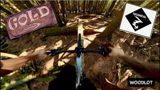
Gold is re-opened.
A re-imagination built in 2020-2021 that pays homage to the original trail (circa 2000). Expect ladder bridges, skinnies, drops, gaps, and a steep rock roll. Most of these options are rated double black diamond and there is an alternate line for all. If it's your first time down the trail, we recommend check the options out before sending it.
| c1 | c2 | c3 | c4 |
|---|---|---|---|
January | February | March | April |
May | June | July | August |
September | October | November | December |

Service Road Atlas is a free to use, community-driven service for viewing and creating reports on the numerous back-country service roads around B.C. and Alberta.
Save the current map location and zoom level as your default home location whenever this page is loaded.
SaveWe hope you've been enjoying Trailforks!
Create a FREE account to view trail comments and much more.
You must enter a description before submitting.

