more stats
1.2 miles
Distance
50 ft
Climb
-91 ft
Descent
00:09:20
Avg time
-40 ft
Altitude change
2,163 ft
Altitude min
2,230 ft
Altitude max
2,205 ft
Altitude start
2,165 ft
Altitude end
-0.6%
Grade
-15.8%
Grade max
9%
Grade min
1,791 ft
Distance climb
2,897 ft
Distance down
1,716 ft
Distance flat
00:09:20
Avg time

Granite Details

  • Activities
    • Mountain Bike
    • E-Bike
    • Gravel Bike
    • Horse
    • Hike
    • Trail Running
  • Riding Area
    McDowell Mountain Regional Park
    Fountain Hills, Arizona
  • Difficulty Rating
  • Local Popularity
    70 in Mountain Biking [+]
    • 70 in E-Biking
    • 60 in Trail Running
    • 75 in Hiking
    • 5 in Horseback
  • Global Ranking
    #80926 in Mountain Biking [+]
    • #11375 in E-Biking
    • #25417 in Trail Running
    • #9402 in Hiking
  • Trail Type
    Dirt/Gravel Road
  • Bike Type
    XC, Gravel
  • Direction
    Both Directions
  • Climb Difficulty
    Green
  • Physical Rating
    Moderate
  • Dogs Allowed
    Yes
  • eBike Allowed
    Yes up to Class 1
  • Ride in Rain
    Yes
  • Land Owner
    Maricopa County Parks

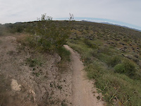
After the summer 2024 fires, most of this portion of the Granite Trail, between the bottom of Delsie and the middle of Bluff is no longer singletrack. Instead a somewhat loose and bumpy service road that drops into, crosses and climbs out of Stoneman wash.

Recent Activity on Trail

Past Week
  • 0 rides
  •  
6 Months
  • 113 rides
  • 27 miles avg distance
All
  • 585 rides
  • Last: Jun 30, 2026
c1c2c3c4
January
February
March
April
May
June
July
August
September
October
November
December
Status:
on Mar 7, 2026
Dry
Avg: 3.49 (6 votes)
Your vote: 0

view (2,645)
close
3D
Trail Conditions
  • Unknown
  • Snow Groomed
  • Snow Packed
  • Snow Covered
  • Snow Cover Partial
  • Freeze/thaw Cycle
  • Icy
  • Prevalent Mud
  • Wet
  • Variable
  • Ideal
  • Dry
  • Very Dry
Trail Flow (Ridden Direction)
Trailforks scans users ridelogs to determine the most popular direction each trail is ridden. A good flowing trail network will have most trails flowing in a single direction according to their intension.
The colour categories are based on what percentage of riders are riding a trail in its intended direction.
  • > 96%
  • > 90%
  • > 80%
  • > 70%
  • > 50%
  • < 50%
  • bi-directional trail
  • no data
Trail Last Ridden
Trailforks scans ridelogs to determine the last time a trail was ridden.
  • < 2 days
  • < 1 week
  • < 2 weeks
  • < 1 month
  • < 6 months
  • > 6 months
Trail Ridden Direction
The intended direction a trail should be ridden.
  • Downhill Only
  • Downhill Primary
  • Both Directions
  • Uphill Primary
  • Uphill Only
  • One Direction
Contribute Details
Colors indicate trail is missing specified detail.
  • Description
  • Photos
  • Description & Photos
  • Videos
Trail Popularity ?
Trailforks scans ridelogs to determine which trails are ridden the most in the last 9 months. Trails are compared with nearby trails in the same city region with a possible 25 colour shades. Think of this as a heatmap, more rides = more kinetic energy = warmer colors.
  • most popular
  • popular
  • less popular
  • not popular
ATV/ORV/OHV Filter
Max Vehicle Width
inches
US Cell Coverage
Legend
cell carrier legend

Radar Time
Activity Recordings
Trailforks uses anonymized public activity data. ?
Activity Recordings
Trailforks uses anonymized public activity data. ?
Personal Heatmap
Activity Types
all / none
Options
2
Date range month
Winter Trails
Warning A routing network for winter maps does not exist. Selecting trails using the winter trails layer has been disabled.
Missing Trails
Most Popular
Least Popular
Trails are colored based on popularity. The more popular a trail is, the more red. Less popular trails trend towards green.
Jump Magnitude Heatmap
Heatmap of where riders jump on trails. Zoom in to see individual jumps, click circles to view jump details.
BC Backroad Status

Service Road Atlas is a free to use, community-driven service for viewing and creating reports on the numerous back-country service roads around B.C. and Alberta.

map legend
Slope Aspect
Direction the slope faces
Flat N NE E SE S SW W NW
Trails Deemphasized
Trails are shown in grey.
disable
Only show trails with no bike usage.
Enable
Suggested Layers
Based on selected activity type

    Save the current map location and zoom level as your default home location whenever this page is loaded.

    Save
        Directions to granite trailhead (33.696390, -111.757510)

        Photos

        3 more »
        63 |
        Feb 2, 2021 @ 10:36am
        Feb 2, 2021
        67 |
        Feb 2, 2021 @ 10:36am
        Feb 2, 2021
        61 |
        Jan 23, 2021 @ 9:06am
        Jan 23, 2021

        Videos

        2 more »
        FULL TRAIL - Granite Trail
        12:04 | 8 | Nov 26, 2023 , Fountain Hills
        Granite Trail. Mcdowell Mountain Regional Park.
        9:31 | 71 | Mar 8, 2019 , Fountain Hills

        Routes with this trail

        5.0 46 miles 3,874 ft 36 Loop
        Off-road portions of the Fountain 50 Race.
        27 miles 1,732 ft 16 Loop
        Here's a great route for the singlespeeders out there. I made this route to take advantage of a single's...
        2.0 15 miles 1,021 ft 12
        Escondido from north to south

        1 Review & Comments


        We hope you've been enjoying Trailforks!

        Create a FREE account to view trail comments and much more.

        • By toddTF Pro Trailforks & contributors
        • #14906 - 1,499 views

        Frequently Asked Questions About Granite

        Where is Granite located?
        Granite is located in McDowell Mountain Regional Park, Fountain Hills, Arizona, United States. It is part of the McDowell Mountain Regional Park trail network. The trailhead is located at coordinates 33.69639, -111.75751.
        What is the elevation gain for Granite?
        Granite has 50 ft of elevation gain. The trail has 91 ft of elevation descent. The elevation ranges from 2,163 ft to 2,230 ft.
        Is Granite a point to point trail?
        Granite is not a point to point trail. The direction is Both Directions. The trail type is dirt/gravel road.
        How long is Granite?
        Granite is 1.2 miles long. The trail type is dirt/gravel road.

        Hit the Trail

        Open in App

        Get this trail on your phone instantly.
        open trail in app

        Download Trail

        Save to wishlist, Garmin & download.
        save the trail

        Find Related Routes

        Find routes and users activities that include this trail.
        find routes for this trail

        You must enter a description before submitting.