more stats
2,943 ft
Distance
-450 ft
Descent
941 ft
High Point
-452 ft
Altitude change
489 ft
Altitude min
941 ft
Altitude start
489 ft
Altitude end
-15.4%
Grade
-31.1%
Grade max
-4.5%
Grade min
2,943 ft
Distance down

Gritty Kitty Details

  • Activities
    • Mountain Bike
    • E-Bike
  • Riding Area
  • Difficulty Rating
  • Local Popularity
    85 in Mountain Biking [+]
    • 60 in E-Biking
  • Trail Type
    Singletrack
  • Dogs Allowed
    Yes
  • eBike Allowed
    Yes up to Class 1
  • TTFs on Trail
    Berm, Roller Coaster, Other
  • Land Owner
    OSU Research Forests

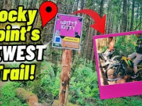
Gritty Kitty has something for everyone and offers a challenge for all skill levels. It has short sections that are moderately steep, corners galore, and some flowy sections. It was built by two NWTA board members and cat lovers who wanted something fast and fun but wouldn't scare the pants off of newer riders. While it can be ridden at high speed, it can also be taken slower so riders can have a safe starting point for getting comfortable with the steeper terrain that RP offers.

The entire trail is in the trees and has three distinct sections, so make sure you ride all three Exit by going right, back up Sad Birthday for a moment and back onto the mid road for more laps! Alternatively, you can exit by going left on Sad Birthday or right on Runaway Return to the bottom and climb out up Lower Mulligan.

Access Info Restricted Access

These trails are not open to the general public. You must be a member of NWTA to access these trails as part of the land use agreement with OSU Research Forests. Please adhere to our land use agreement with OSU Research Forests.

Local Trail Association

Recent Activity on Trail

Past Week
  • 5 rides
  • 11 miles average
6 Months
  • 111 rides
  • 11 miles avg distance
All
  • 258 rides
  • Last: Jun 28, 2026
c1c2c3c4
January
February
March
April
May
June
July
August
September
October
November
December
Status:
on Jun 10, 2026
Ideal
Avg: 4.65 (3 votes)
Your vote: 0

view (1,079)
close
3D
Trail Conditions
  • Unknown
  • Snow Groomed
  • Snow Packed
  • Snow Covered
  • Snow Cover Partial
  • Freeze/thaw Cycle
  • Icy
  • Prevalent Mud
  • Wet
  • Variable
  • Ideal
  • Dry
  • Very Dry
Trail Flow (Ridden Direction)
Trailforks scans users ridelogs to determine the most popular direction each trail is ridden. A good flowing trail network will have most trails flowing in a single direction according to their intension.
The colour categories are based on what percentage of riders are riding a trail in its intended direction.
  • > 96%
  • > 90%
  • > 80%
  • > 70%
  • > 50%
  • < 50%
  • bi-directional trail
  • no data
Trail Last Ridden
Trailforks scans ridelogs to determine the last time a trail was ridden.
  • < 2 days
  • < 1 week
  • < 2 weeks
  • < 1 month
  • < 6 months
  • > 6 months
Trail Ridden Direction
The intended direction a trail should be ridden.
  • Downhill Only
  • Downhill Primary
  • Both Directions
  • Uphill Primary
  • Uphill Only
  • One Direction
Contribute Details
Colors indicate trail is missing specified detail.
  • Description
  • Photos
  • Description & Photos
  • Videos
Trail Popularity ?
Trailforks scans ridelogs to determine which trails are ridden the most in the last 9 months. Trails are compared with nearby trails in the same city region with a possible 25 colour shades. Think of this as a heatmap, more rides = more kinetic energy = warmer colors.
  • most popular
  • popular
  • less popular
  • not popular
ATV/ORV/OHV Filter
Max Vehicle Width
inches
US Cell Coverage
Legend
cell carrier legend

Radar Time
Activity Recordings
Trailforks uses anonymized public activity data. ?
Activity Recordings
Trailforks uses anonymized public activity data. ?
Personal Heatmap
Activity Types
all / none
Options
2
Date range month
Winter Trails
Warning A routing network for winter maps does not exist. Selecting trails using the winter trails layer has been disabled.
Missing Trails
Most Popular
Least Popular
Trails are colored based on popularity. The more popular a trail is, the more red. Less popular trails trend towards green.
Jump Magnitude Heatmap
Heatmap of where riders jump on trails. Zoom in to see individual jumps, click circles to view jump details.
BC Backroad Status

Service Road Atlas is a free to use, community-driven service for viewing and creating reports on the numerous back-country service roads around B.C. and Alberta.

map legend
Slope Aspect
Direction the slope faces
Flat N NE E SE S SW W NW
Trails Deemphasized
Trails are shown in grey.
disable
Only show trails with no bike usage.
Enable
Suggested Layers
Based on selected activity type

    Save the current map location and zoom level as your default home location whenever this page is loaded.

    Save
        Directions to gritty-kitty trailhead (45.686600, -122.900830)

        Photos

        1 more »
        18 |
        Jun 2, 2026 @ 8:25pm
        Jun 2, 2026

        Videos

        2 more »
        Gritty Kitty with Builder Carrie
        131 | Jun 24, 2025 , Portland
        If you like flow trails you will love this ...
        74 | Jun 15, 2025 , Portland

        1 Review & Comments


        We hope you've been enjoying Trailforks!

        Create a FREE account to view trail comments and much more.

        • By Scooter1TF Pro NWTA & contributors
        • #841798 - 390 views

        Frequently Asked Questions About Gritty Kitty

        Where is Gritty Kitty located?
        Gritty Kitty is located in Tualatin Mountain Forest (Rocky Point Trails), Portland, Oregon, United States. It is part of the Tualatin Mountain Forest (Rocky Point Trails) trail network. The trailhead is located at coordinates 45.6866, -122.90083.
        How hard is Gritty Kitty?
        Gritty Kitty is rated as Blue difficulty. The average grade is 15.4%.
        What is the elevation gain for Gritty Kitty?
        The trail has 450 ft of elevation descent. The elevation ranges from 489 ft to 941 ft.
        How long is Gritty Kitty?
        Gritty Kitty is 2,943 ft long. The trail type is singletrack.

        Hit the Trail

        Open in App

        Get this trail on your phone instantly.
        open trail in app

        Download Trail

        Save to wishlist, Garmin & download.
        save the trail

        Find Related Routes

        Find routes and users activities that include this trail.
        find routes for this trail

        You must enter a description before submitting.