This trail is permanently closed/decommissioned
more stats
509 ft
Distance
-39 ft
Descent
00:00:36
Avg time
-40 ft
Altitude change
123 ft
Altitude min
164 ft
Altitude max
164 ft
Altitude start
125 ft
Altitude end
-7.9%
Grade
-21.7%
Grade max
-1.2%
Grade min
56 ft
Distance climb
453 ft
Distance down
00:00:36
Avg time

Groot Details

  • Activities
    • Mountain Bike
  • Riding Area
    Seabrook
    , Washington
  • Difficulty Rating
  • Voted Difficulty
    Black Diamond (2 votes)
  • Local Popularity
    35 in Mountain Biking
  • Trail Type
    Singletrack
  • Bike Type
    DH
  • Direction
    One Direction
    Popular Direction Shown
  • Climb Difficulty
    Green
  • Physical Rating
    Moderate
  • Season
    April - October
  • Dogs Allowed
    Yes
  • eBike Allowed
  • TTFs on Trail
    Drop
  • Year Opened
    2015

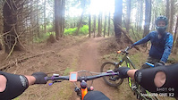
A short technical rooty downhill from near the start of Mike-o-Rama to the gate near Hwy 109. A lot of side-tracking off-camber singletrack with some steep very technical root sections. Quarter-mile long track with 50-feet of elevation change.

Trail Supporters
Local Trail Association
Traditionally Indigenous Territory

Recent Activity on Trail

Past Week
  • 0 rides
  •  
6 Months
  • 0 rides
  •  
All
  • 28 rides
  • Last: Aug 9, 2025
c1c2c3c4
January
February
March
April
May
June
July
August
September
October
November
December
update trails status or condition

Groot Trail Reports

statusdatedescription
Aug 22, 2021 @ 8:26am
Aug 22, 2021
The private land owner has asked the trail to be closed
Aug 16, 2021 @ 4:55pm
Aug 16, 2021
Groot is ready for challengers! Pick your line and try not to dab....
Apr 30, 2021 @ 4:51pm
Apr 30, 2021
Thanks Jesse for making some adjustments. It’s still challenging but a bit more rideable. One of these days I’ll make it all the way down.
Feb 24, 2021 @ 7:33am
Feb 24, 2021
Lots of small branches down, proceed with caution
Jan 20, 2021 @ 12:59pm
Jan 20, 2021
I would say it definitely earns it's diamond status. It seemed pretty dangerous to me. Leave it to the pros.
more »
Status:
on Aug 22, 2021
Avg: 4.19 (4 votes)
Your vote: 0

view (188)
close
3D
Trail Conditions
  • Unknown
  • Snow Groomed
  • Snow Packed
  • Snow Covered
  • Snow Cover Partial
  • Freeze/thaw Cycle
  • Icy
  • Prevalent Mud
  • Wet
  • Variable
  • Ideal
  • Dry
  • Very Dry
Trail Flow (Ridden Direction)
Trailforks scans users ridelogs to determine the most popular direction each trail is ridden. A good flowing trail network will have most trails flowing in a single direction according to their intension.
The colour categories are based on what percentage of riders are riding a trail in its intended direction.
  • > 96%
  • > 90%
  • > 80%
  • > 70%
  • > 50%
  • < 50%
  • bi-directional trail
  • no data
Trail Last Ridden
Trailforks scans ridelogs to determine the last time a trail was ridden.
  • < 2 days
  • < 1 week
  • < 2 weeks
  • < 1 month
  • < 6 months
  • > 6 months
Trail Ridden Direction
The intended direction a trail should be ridden.
  • Downhill Only
  • Downhill Primary
  • Both Directions
  • Uphill Primary
  • Uphill Only
  • One Direction
Contribute Details
Colors indicate trail is missing specified detail.
  • Description
  • Photos
  • Description & Photos
  • Videos
Trail Popularity ?
Trailforks scans ridelogs to determine which trails are ridden the most in the last 9 months. Trails are compared with nearby trails in the same city region with a possible 25 colour shades. Think of this as a heatmap, more rides = more kinetic energy = warmer colors.
  • most popular
  • popular
  • less popular
  • not popular
ATV/ORV/OHV Filter
Max Vehicle Width
inches
US Cell Coverage
Legend
cell carrier legend

Radar Time
Activity Recordings
Trailforks uses anonymized public activity data. ?
Activity Recordings
Trailforks uses anonymized public activity data. ?
Personal Heatmap
Activity Types
all / none
Options
2
Date range month
Winter Trails
Warning A routing network for winter maps does not exist. Selecting trails using the winter trails layer has been disabled.
Missing Trails
Most Popular
Least Popular
Trails are colored based on popularity. The more popular a trail is, the more red. Less popular trails trend towards green.
Jump Magnitude Heatmap
Heatmap of where riders jump on trails. Zoom in to see individual jumps, click circles to view jump details.
BC Backroad Status

Service Road Atlas is a free to use, community-driven service for viewing and creating reports on the numerous back-country service roads around B.C. and Alberta.

map legend
Slope Aspect
Direction the slope faces
Flat N NE E SE S SW W NW
Trails Deemphasized
Trails are shown in grey.
disable
Only show trails with no bike usage.
Enable
Suggested Layers
Based on selected activity type

    Save the current map location and zoom level as your default home location whenever this page is loaded.

    Save
        Directions to groot trailhead (47.189200, -124.194360)

        Photos

        2 more »
        181 |
        Jul 21, 2019 @ 10:02am
        Jul 21, 2019
        168 |
        Aug 2, 2018 @ 1:35pm
        Aug 2, 2018

        Videos

        2 more »
        Groot (aka Downhill), Seabrook, WA
        0:54 | 1127 | Aug 23, 2018 , Seabrook
        0:21 | 226 | May 16, 2021 , Seabrook

        8 Reviews & Comments


        We hope you've been enjoying Trailforks!

        Create a FREE account to view trail comments and much more.

        • By buckgilesTF Pro & contributors
        • #104534 - 2,004 views

        Frequently Asked Questions About Groot

        Where is Groot located?
        Groot is located in Seabrook, Washington, United States. It is part of the Seabrook trail network. The trailhead is located at coordinates 47.1892, -124.19436.
        How hard is Groot?
        Groot is rated as Black Diamond difficulty. The physical rating is Moderate. The average grade is 7.9%. The climb difficulty is rated Green.
        What is the elevation gain for Groot?
        The trail has 39 ft of elevation descent. The elevation ranges from 123 ft to 164 ft.
        Is Groot a point to point trail?
        Yes, Groot is a point to point trail. The direction is One Direction. The trail type is singletrack.

        Hit the Trail

        Open in App

        Get this trail on your phone instantly.
        open trail in app

        Download Trail

        Save to wishlist, Garmin & download.
        save the trail

        Find Related Routes

        Find routes and users activities that include this trail.
        find routes for this trail

        You must enter a description before submitting.