4,647 ft
Distance
135 ft
Climb
-239 ft
Descent
00:06:21
Avg time
GWT Details
-
Activities
- Mountain Bike
- Hike
- Trail Running
-
Riding AreaProvo Canyon
Provo, Utah -
Difficulty Rating
-
Hiking SAC ScaleT1 Hiking
-
Trail TypeSingletrack
-
Bike TypeXC
-
DirectionBoth Directions
-
Climb DifficultyBlue
-
Dogs AllowedYes
-
Global Ranking#45679 in Mountain Biking
-
Local Popularity85 in Mountain Biking [+]
- 85 in Trail Running
- 70 in Hiking
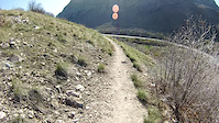
Good connector from Johnson Hole down to the canyon. Follows along the canyon cliff. Difficulty is expert because the beginning is a bit technical, but more because of the sheer cliffs with loose rock. Cost of failure could be high.
More Stats for GWT mountain bike trail trail
-
Altitude change-104 ft
-
Altitude min5,071 ft
-
Altitude max5,193 ft
-
Altitude start5,175 ft
-
Altitude end5,071 ft
-
Grade-2.234%
-
Grade max-65.338%
-
Grade min19.324%
-
Distance climb2,213 ft
-
Distance down2,340 ft
-
Distance flat94 ft
-
Avg time00:06:21
-
Avg reverse time00:09:58
- view trail stats
close
Trail Conditions
- Unknown
- Snow Groomed
- Snow Packed
- Snow Covered
- Freeze/thaw Cycle
- Icy
- Prevalent Mud
- Wet
- Variable
- Ideal
- Dry
- Very Dry
Trail Ridden Direction
Trailforks scans users ridelogs to determine the most popular direction each trail is ridden. A good flowing trail network will have most trails flowing in a single direction according to their intension.
The colour categories are based on what percentage of riders are riding a trail in its intended direction.
- > 96%
- > 90%
- > 80%
- > 70%
- > 50%
- < 50%
Trail Last Ridden
Trailforks scans ridelogs to determine the last time a trail was ridden.
- < 2 days
- < 1 week
- < 2 weeks
- < 1 month
- < 6 months
- > 6 months
Trail Ridden Direction
The intended direction a trail should be ridden.
- Downhill Only
- Downhill Primary
- Both Directions
- Uphill Primary
- Uphill Only
- One Direction
ContributeDetails
Colors indicate trail is missing specified detail.
- Description
- Photos
- Description & Photos
- Videos
Trail Popularity ?
Trailforks scans ridelogs to determine which trails are ridden the most in the last 9 months.
Trails are compared with nearby trails in the same city region with a possible 25 colour shades.
Think of this as a heatmap, more rides = more kinetic energy = warmer colors.
- most popular
- popular
- less popular
- not popular
ATV/ORV/OHV Filter
Max Vehicle Width
inches
Radar Time
LEGEND
Trail Difficulties
Trail Report Status
- Access Road/Trail
- White
- Green
- Blue
- Black
- Double Black Diamond
Trail Report Status
- Clear / Green
- Minor Issue / Yellow
- Significant Issue / Amber
- Closed
- Land Owner Overlay
- Wilderness (typically no bikes in USA)
- BLM (public)
- USFS (Wildlife sanctuaries darker than usfs)
- State land
- Indigenous
- Military
Trail Conditions
- Unknown
- Snow Groomed
- Snow Packed
- Snow Covered
- Freeze/thaw Cycle
- Icy
- Prevalent Mud
- Wet
- Variable
- Ideal
- Dry
- Very Dry
- Map Markers
Trail Head
Photo
Directory Listing
Riding Area
TTF
Parking
Viewpoint
Information
Warning
Directions
Sight
Restrooms
eBike Charging Point
Water Fountain/Source
Gate
Trail Sign
Table or Bench
Ladder
Stairs
Bridge
Boardwalk
Camping
Cabin
Lodge
Bear Cache
Dock
Ranger Station
Summit
Other
Directions to gwt trailhead
(40.331610, -111.620890)
update trails status or condition
GWT Trail Reports
view all reports »
Recent Ridelog Activity on Trail
Past Week
- 0 rides
6 Months
- 76 rides
- 17 miles avg distance
All
- 377 rides
Photos
more »
Trail Lists
-
Dry canyon DH trails13 trails
Routes with this trail
more »
-
+ 1

Not sure why anyone would rate this a black trail. It's easy to ride in either direction with no technical features whatsoever. There is a little bit of exposure, but nothing scary. This should be rated green or at most a mild blue.
[Reply]
I changed it to blue. The trail was imported from another database which had the trail added back in 2010 before the bridge. The exposure was really bad, and it was really difficult before the construction where it turns off to the old river bridge. But yah, I didn't realize this was still a black. I don't want to send families with little kids with that exposure, so I'll keep it blue.
[Reply]
Nearby Trails
- Pipeline 82 ft
- Bridesmaid Falls 3,120 ft
- Bonneville Shoreline Trail: Provo Canyon South 1 mile
- Jungle Love 1 mile
- Dragons Back (gwt/bst) 1 mile
- embed GWT trail on your website
- By todd
Trailforks Plus & contributors
- #9512 - 1,006 views
- subscribe
- login to download gpx or kml files.
Open trail in mobile app