more stats
6.1 miles
Distance
619 ft
Climb
-610 ft
Descent
00:41:52
Avg time
6 ft
Altitude change
890 ft
Altitude min
1,004 ft
Altitude max
891 ft
Altitude start
899 ft
Altitude end
-27.8%
Grade max
31.6%
Grade min
2 miles
Distance climb
2 miles
Distance down
2 miles
Distance flat
00:41:52
Avg time

Hard Loop Details

  • Activities
    • Mountain Bike
    • Winter Fat Bike
    • Hike
    • Trail Running
  • Riding Area
    Murphy-Hanrehan Park
    Savage, Minnesota
  • Difficulty Rating
  • Voted Difficulty
    Blue (3 votes)
  • Local Popularity
    90 in Mountain Biking [+]
    • 25 in Trail Running
    • 30 in Hiking
  • Global Ranking
    #51931 in Mountain Biking [+]
    • #127208 in Trail Running
    • #117287 in Hiking
  • Trail Type
    Singletrack
  • Bike Type
    AM, XC, Fat
  • Direction
    One Direction
  • Climb Difficulty
    Blue
  • Physical Rating
    Moderate
  • Trail Visibility
    Always easy to follow
  • TTFs on Trail
    Bridge, Log Ride, Rock Face, Rock Garden, Skinny
  • Land Owner
    Three Rivers Park District

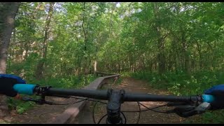
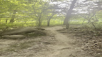
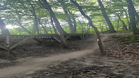
This is the hard loop, but I think it is relative to this trail system. The majority of the trail itself is actually easy, with a little bit of roots and a few spots that are difficult to get over. The expert designation probably comes from a few rock gardens and the expert level features that exist along the trail. But most of these features have a roll around option, or they are short. The most prominent expert feature are the tight bumpy rock gardens, but they are very short considering the long length of this loop.

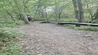
Like the other loops, this loop has many emergency exits that allow you to cut off the trail and return back quickly. Look for signs on the side that say "Technical Feature" if you want to try out some of the skinnies, log rides, and some other interesting little wood features.

Local Trail Association
Traditionally Indigenous Territory

Recent Activity on Trail

Past Week
  • 6 rides
  • 12 miles average
6 Months
  • 127 rides
  • 11 miles avg distance
All
  • 1,324 rides
  • Last: Jun 24, 2026
c1c2c3c4
January
February
March
April
May
June
July
August
September
October
November
December
update trails status or condition

Hard Loop Trail Reports

Status:
on Oct 18, 2025
Dry
Avg: 4.39 (5 votes)
Your vote: 0

view (15,559)
close
3D
Trail Conditions
  • Unknown
  • Snow Groomed
  • Snow Packed
  • Snow Covered
  • Snow Cover Partial
  • Freeze/thaw Cycle
  • Icy
  • Prevalent Mud
  • Wet
  • Variable
  • Ideal
  • Dry
  • Very Dry
Trail Flow (Ridden Direction)
Trailforks scans users ridelogs to determine the most popular direction each trail is ridden. A good flowing trail network will have most trails flowing in a single direction according to their intension.
The colour categories are based on what percentage of riders are riding a trail in its intended direction.
  • > 96%
  • > 90%
  • > 80%
  • > 70%
  • > 50%
  • < 50%
  • bi-directional trail
  • no data
Trail Last Ridden
Trailforks scans ridelogs to determine the last time a trail was ridden.
  • < 2 days
  • < 1 week
  • < 2 weeks
  • < 1 month
  • < 6 months
  • > 6 months
Trail Ridden Direction
The intended direction a trail should be ridden.
  • Downhill Only
  • Downhill Primary
  • Both Directions
  • Uphill Primary
  • Uphill Only
  • One Direction
Contribute Details
Colors indicate trail is missing specified detail.
  • Description
  • Photos
  • Description & Photos
  • Videos
Trail Popularity ?
Trailforks scans ridelogs to determine which trails are ridden the most in the last 9 months. Trails are compared with nearby trails in the same city region with a possible 25 colour shades. Think of this as a heatmap, more rides = more kinetic energy = warmer colors.
  • most popular
  • popular
  • less popular
  • not popular
ATV/ORV/OHV Filter
Max Vehicle Width
inches
US Cell Coverage
Legend
cell carrier legend

Radar Time
Activity Recordings
Trailforks uses anonymized public activity data. ?
Activity Recordings
Trailforks uses anonymized public activity data. ?
Personal Heatmap
Activity Types
all / none
Options
2
Date range month
Winter Trails
Warning A routing network for winter maps does not exist. Selecting trails using the winter trails layer has been disabled.
Missing Trails
Most Popular
Least Popular
Trails are colored based on popularity. The more popular a trail is, the more red. Less popular trails trend towards green.
Jump Magnitude Heatmap
Heatmap of where riders jump on trails. Zoom in to see individual jumps, click circles to view jump details.
BC Backroad Status

Service Road Atlas is a free to use, community-driven service for viewing and creating reports on the numerous back-country service roads around B.C. and Alberta.

map legend
Slope Aspect
Direction the slope faces
Flat N NE E SE S SW W NW
Trails Deemphasized
Trails are shown in grey.
disable
Only show trails with no bike usage.
Enable
Suggested Layers
Based on selected activity type

    Save the current map location and zoom level as your default home location whenever this page is loaded.

    Save
        Directions to hard-loop trailhead (44.718340, -93.343480)

        Photos

        16 more »
        727 |
        Aug 21, 2018 @ 10:29am
        Aug 21, 2018
        636 |
        Aug 21, 2018 @ 9:27am
        Aug 21, 2018
        18 |
        May 25, 2026 @ 1:28pm
        May 25, 2026
        403 |
        Nov 21, 2019 @ 1:20pm
        Nov 21, 2019

        Videos

        4 more »
        Fast and Fun | Mountain Biking the Hard/Black...
        18:12 | 310 | Oct 2, 2023 , Savage
        Rock roll over
        0:06 | | Jul 4, 2021 , Savage
        Advanced Feature Skinny
        0:22 | | Jul 4, 2021 , Savage
        Murphy step down
        0:07 | | Jul 4, 2021 , Savage

        Routes with this trail

        42 miles 2,485 ft 11
        Loops at Leb, terrace oaks, and murphy

        1 Review & Comments


        We hope you've been enjoying Trailforks!

        Create a FREE account to view trail comments and much more.

        • By voghanTF Pro & contributors
        • #61388 - 4,159 views

        Frequently Asked Questions About Hard Loop

        Where is Hard Loop located?
        Hard Loop is located in Murphy-Hanrehan Park, Savage, Minnesota, United States. It is part of the Murphy-Hanrehan Park trail network. The trailhead is located at coordinates 44.71834, -93.34348.
        How hard is Hard Loop?
        Hard Loop is rated as Blue difficulty. The physical rating is Moderate. The climb difficulty is rated Blue.
        What is the elevation gain for Hard Loop?
        Hard Loop has 619 ft of elevation gain. The trail has 610 ft of elevation descent. The elevation ranges from 890 ft to 1,004 ft.
        Is Hard Loop a point to point trail?
        Yes, Hard Loop is a point to point trail. The direction is One Direction. The trail type is singletrack.

        Hit the Trail

        Open in App

        Get this trail on your phone instantly.
        open trail in app

        Download Trail

        Save to wishlist, Garmin & download.
        save the trail

        Find Related Routes

        Find routes and users activities that include this trail.
        find routes for this trail

        You must enter a description before submitting.