1,575 ft
Distance
5 ft
Climb
-126 ft
Descent
00:04:31
Avg time
Henriks Details
-
Activities
- Mountain Bike
-
Riding AreaMölnlycke
Härryda -
Difficulty Rating
-
Trail TypeSingletrack
-
Bike TypeDH, AM
-
Trail UsageBiking Only
-
DirectionDownhill OnlyPopular direction shown
-
Dogs AllowedYes
-
eBike Allowed
-
TTFs on TrailDrop
-
Global Ranking#15764 in Mountain Biking
-
Local Popularity100 in Mountain Biking
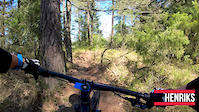
Startar uppe på norra höjden på Lejonklippan. Inledningsvis single track med en del tramp. Ändrar sedan karaktär till snabb och brant utför.
More Stats for Henriks mountain bike trail trail
-
Altitude change-121 ft
-
Altitude min285 ft
-
Altitude max413 ft
-
Altitude start407 ft
-
Altitude end285 ft
-
Grade-7.7%
-
Grade max-29.2%
-
Grade min3.9%
-
Distance climb128 ft
-
Distance down1,142 ft
-
Distance flat217 ft
-
Avg time00:04:31
-
Avg reverse time00:07:54
- view trail stats
close
Trail Conditions
- Unknown
- Snow Groomed
- Snow Packed
- Snow Covered
- Freeze/thaw Cycle
- Icy
- Prevalent Mud
- Wet
- Variable
- Ideal
- Dry
- Very Dry
Trail Ridden Direction
Trailforks scans users ridelogs to determine the most popular direction each trail is ridden. A good flowing trail network will have most trails flowing in a single direction according to their intension.
The colour categories are based on what percentage of riders are riding a trail in its intended direction.
- > 96%
- > 90%
- > 80%
- > 70%
- > 50%
- < 50%
Trail Last Ridden
Trailforks scans ridelogs to determine the last time a trail was ridden.
- < 2 days
- < 1 week
- < 2 weeks
- < 1 month
- < 6 months
- > 6 months
Trail Ridden Direction
The intended direction a trail should be ridden.
- Downhill Only
- Downhill Primary
- Both Directions
- Uphill Primary
- Uphill Only
- One Direction
ContributeDetails
Colors indicate trail is missing specified detail.
- Description
- Photos
- Description & Photos
- Videos
Trail Popularity ?
Trailforks scans ridelogs to determine which trails are ridden the most in the last 9 months.
Trails are compared with nearby trails in the same city region with a possible 25 colour shades.
Think of this as a heatmap, more rides = more kinetic energy = warmer colors.
- most popular
- popular
- less popular
- not popular
ATV/ORV/OHV Filter
Max Vehicle Width
inches
Radar Time
LEGEND
Trail Difficulties
Trail Report Status
- Access Road/Trail
- White
- Green
- Blue
- Black
- Double Black Diamond
Trail Report Status
- Clear / Green
- Minor Issue / Yellow
- Significant Issue / Amber
- Closed
- Land Owner Overlay
- Wilderness (typically no bikes in USA)
- BLM (public)
- USFS (Wildlife sanctuaries darker than usfs)
- State land
- Indigenous
- Military
Trail Conditions
- Unknown
- Snow Groomed
- Snow Packed
- Snow Covered
- Freeze/thaw Cycle
- Icy
- Prevalent Mud
- Wet
- Variable
- Ideal
- Dry
- Very Dry
- Map Markers
Trail Head
Photo
Directory Listing
Riding Area
TTF
Parking
Viewpoint
Information
Warning
Directions
Sight
Restrooms
eBike Charging Point
Water Fountain/Source
Gate
Trail Sign
Table or Bench
Ladder
Stairs
Bridge
Boardwalk
Camping
Cabin
Lodge
Bear Cache
Dock
Ranger Station
Summit
Other
Directions to henriks trailhead
(57.643920, 12.142850)
update trails status or condition
Henriks Trail Reports
view all reports »
Recent Ridelog Activity on Trail
Past Week
- 1 rides
- 7 miles avg distance
6 Months
- 100 rides
- 9 miles avg distance
All
- 603 rides
Photos
more »
Routes with this trail
Reviews / Comments
No reviews yet, be the first to write a review or ask a question.
Use trail reports to comment on trail conditions.
Nearby Trails
- Hardrock Café 348 ft
- Rabiat Undulat 354 ft
- Eriks Propeller 354 ft
- Till Henriks Och Sideways 486 ft
- Grönis 522 ft
- embed Henriks trail on your website
- By PatternsOn
GSC & contributors
- #102739 - 530 views
- subscribe
- login to download gpx or kml files.
Open trail in mobile app