close
-
Layers w
- Weather Layers
- Pro
- Pro
- Pro
- Pro
- Pro
- Pro
- More Layers
- Pro
- Pro
- Pro
- Pro
-
Upgrade to

3D
Trail Conditions
- Unknown
- Snow Groomed
- Snow Packed
- Snow Covered
- Snow Cover Partial
- Freeze/thaw Cycle
- Icy
- Prevalent Mud
- Wet
- Variable
- Ideal
- Dry
- Very Dry
Trail Flow (Ridden Direction)
Trailforks scans users ridelogs to determine the most popular direction each trail is ridden. A good flowing trail network will have most trails flowing in a single direction according to their intension.
The colour categories are based on what percentage of riders are riding a trail in its intended direction.
The colour categories are based on what percentage of riders are riding a trail in its intended direction.
- > 96%
- > 90%
- > 80%
- > 70%
- > 50%
- < 50%
- bi-directional trail
- no data
Trail Last Ridden
Trailforks scans ridelogs to determine the last time a trail was ridden.
- < 2 days
- < 1 week
- < 2 weeks
- < 1 month
- < 6 months
- > 6 months
Trail Ridden Direction
The intended direction a trail should be ridden.
- Downhill Only
- Downhill Primary
- Both Directions
- Uphill Primary
- Uphill Only
- One Direction
Contribute Details
Colors indicate trail is missing specified detail.
- Description
- Photos
- Description & Photos
- Videos
Trail Popularity ?
Trailforks scans ridelogs to determine which trails are ridden the most in the last 9 months.
Trails are compared with nearby trails in the same city region with a possible 25 colour shades.
Think of this as a heatmap, more rides = more kinetic energy = warmer colors.
- most popular
- popular
- less popular
- not popular
ATV/ORV/OHV Filter
Max Vehicle Width
inches
US Cell Coverage
Legend

Radar Time
Activity Recordings
Trailforks uses anonymized public activity data.
?
Activity Recordings
Trailforks uses anonymized public activity data.
?
Personal Heatmap
▶
Activity Types
all
/
none
▶
Options
2
Date range
month
–
Winter Trails
Warning
A routing network for winter maps does not exist. Selecting trails using the winter trails layer has been disabled.
Missing Trails
Most Popular
Least Popular
Trails are colored based on popularity. The more popular a trail is, the more red. Less popular trails trend towards green.
Jump Magnitude Heatmap
Heatmap of where riders jump on trails. Zoom in to see individual jumps, click circles to view jump details.
BC Backroad Status
![map legend]()
Service Road Atlas is a free to use, community-driven service for viewing and creating reports on the numerous back-country service roads around B.C. and Alberta.

Slope Aspect
Direction the slope faces
Trails Deemphasized
Trails are shown in grey.
Only show trails with no bike usage.
Suggested Layers
Based on selected activity type
Save the current map location and zoom level as your default home location whenever this page is loaded.
Save
No description for Härryda has been added yet!
Login or register to submit one.
This region uses the Uk/Euro style trail grading system.
Activities Click to view
- Mountain Bike
943 trails
- E-Bike
271 trails
- Gravel Bike
0 trails
- Adaptive Bike
0 trails
- Winter Fat Bike
0 trails
- Horse
47 trails
- Hike
927 trails
- Trail Running
928 trails
- Nordic Ski
8 trails
Region Details
- 147
- 367
- 363
- 57
- 5
- 1
Region Status
Open as of 2 daysStats
- Avg Trail Rating
- Trails (view details)
- 960
- Trails Mountain Bike
- 945
- Trails E-Bike
- 271
- Trails Horse
- 47
- Trails Hike
- 927
- Trails Trail Running
- 928
- Trails Nordic Ski
- 8
- Total Distance
- 343 miles
- Total Descent
- 34,016 ft
- Total Vertical
- 575 ft
- Highest Trailhead
- 719 ft
- Reports
- 2,953
- Photos
- 333
- Ridden Counter
- 42,167
Sub Regions
-
Härryda
- 26
- 18
-
Hindås
- 72
- 66
- 8
-
Landvetter
- 108
- 122
- 8
-
Mölnlycke
- 99
- 93
- 33
- 4
- 1
-
Rävlanda
- 62
- 63
- 8
- 1
Popular Härryda Mountain Biking Trails
• 100 ★ 4.3 • 1,096 ft • 30 ft • 388 •
Popular blue difficulty singletrack. This mountain bike primary trail can be used uphill primary with a 30 ft blue climb. On average it takes 3 minutes to complete this trail.
• 100 ★ 4.5 • 974 ft • 0 ft • 376 •
WeeRideSlingan är en del av Mölnlyckes mtb-satsning och utvecklas kontinuerligt av WeeRide (Sjövalla)
• 100 ★ 4.5 • 1,086 ft • 3 ft • 309 •
Startar uppe på norra höjden på Lejonklippan. Inledningsvis single track med en del tramp. Ändrar sedan karaktär till snabb och brant utför.
• 100 ★ 3.7 • 2,047 ft • 54 ft • 308 •
är en rolig stig i Mölnlycke, perfekt för MTB-entusiaster som älskar fart och flow eller för dig som precis börjat och vill ha en lugnare tur. Du bestämmer själv hur snabbt eller långsamt det ska gå. Denna stig är fylld med...
• 100 ★ 4.0 • 1,024 ft • 112 ft • 298 •
är en legendarisk uppförsled i Mölnlycke som en gång i tiden var det häftigaste man kunde cykla utför, då med namnet Down . Idag används den oftast som en utmanande väg upp till Råberget. Man hör på namnet att det här blir...
• 95 ★ 5.0 • 1,037 ft • 20 ft • 280 •
Popular blue difficulty singletrack. This multi-use trail can be used both directions and has a easy overall physical rating with a 20 ft green climb. It features ladder bridge and rock face. On average it takes 1 minutes to complete this trail.
Härryda Mountain Bike Routes
★ 4.4 • 4 miles • 418 ft • 8 • Loop •
Landehof MTB-slinga. Start från Landehofstugan. Markerad med blåa band och pilar.
6 miles • 959 ft • 7 • Loop •
Sträckor inför Svartvitt Mölnlycke 2019. SS1: SS2: SS3: + Sekatören SS4: Erics propeller (Popitop med...
7 miles • 659 ft • 11 • Loop •
Små, slingarande singeltracks i Landvetters finaste skogar. Ett kort parti på grusväg(uppför). Två...
9 miles • 1,192 ft • 8 • Loop •
Tänkt bana för SvartVitt Mölnlycke 17 okt 2021. Kan komma att ändras beroende på väder.
22 miles • 2,223 ft • 21 • Loop •
En lite längre tur av långloppskaraktär i mycket blandad miljö med fina vyer och härlig...
5 miles • 625 ft • 20 • Loop •
Route focused on the easy greens in Finsjön area, with a touch of blue ( ) trail at the end.
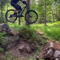
Photos of Härryda Mountain Bike
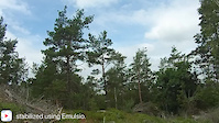
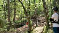
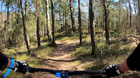
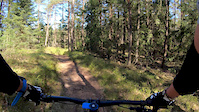
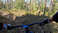
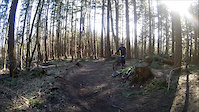
Videos of Härryda Mountain Bike
trail: King Of Bongo
0:29 |
229 |
Jun 23, 2021
trail: Boba Fett
0:58 |
87 |
Jun 23, 2021
trail: King Of Bongo
0:10 |
|
Jun 5, 2020
trail: Finnsjövägen Warp Zone
0:41 |
60 |
May 1, 2020
trail: Blåbärsskogen
3:05 |
103 |
May 1, 2020
trail: Kvarg Gör Dig Arg
2:42 |
350 |
May 1, 2020
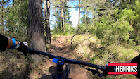
trail: Henriks
2:50 |
292 |
May 1, 2020
trail: Berms
5:40 |
452 |
Mar 14, 2016
Current Trail Warnings
| status | trail | date | condition | user | info |
|---|---|---|---|---|---|
| Vattenfallet | Jul 14, 2026 @ 3:11pm (Europe/Stockholm) Jul 14, 2026 | Variable | nixon88 | Det är numera inte bara väderskydd för... |
Recent Trail Reports
| status | trail | date | condition | info | user |
|---|---|---|---|---|---|
| Vägslänten | Jul 17, 2026 @ 3:14pm (Europe/Stockholm) Jul 17, 2026 | Ideal | ForsmanFredrik | ||
| Björkkorridoren | Jul 13, 2026 @ 2:11pm (Europe/Copenhagen) Jul 13, 2026 | Ideal | falcken87 | ||
| Vildmarksleden, Härskogen-Hindås 1 | Jul 13, 2026 @ 1:48pm (Europe/Stockholm) Jul 13, 2026 | Ideal | joakimP | ||
| Vildmarksleden, Grusväg | Jul 13, 2026 @ 1:48pm (Europe/Stockholm) Jul 13, 2026 | Dry | joakimP | ||
| Solsten Hålsjön | Jul 9, 2026 @ 8:23pm (Europe/Stockholm) Jul 9, 2026 | Ideal | ForsmanFredrik | ||
| Ugglebäcken | Jul 9, 2026 @ 8:23pm (Europe/Stockholm) Jul 9, 2026 | Ideal | ForsmanFredrik | ||
| Lilla Hålsjön | Jul 9, 2026 @ 8:23pm (Europe/Stockholm) Jul 9, 2026 | Ideal | ForsmanFredrik | ||
| Mörket | Jul 9, 2026 @ 8:23pm (Europe/Stockholm) Jul 9, 2026 | Ideal | ForsmanFredrik | ||
| Skvaltkvarn 1 | Jul 9, 2026 @ 8:23pm (Europe/Stockholm) Jul 9, 2026 | Ideal | ForsmanFredrik | ||
| Lilla Hålsjön Viltstig | Jul 1, 2026 @ 9:52am (Europe/Stockholm) Jul 1, 2026 | Variable | Trush61 |
Activity Feed
| username | action | type | title | date |
|---|---|---|---|---|
| ForsmanFredrik | add | report | activity #99431518 and 2 more | Jul 18, 2026 @ 3:46am 3 days |
| ForsmanFredrik | add | report | activity #99263148 and 2 more | Jul 15, 2026 @ 2:31pm Jul 15, 2026 |
| nixon88 | add | report | activity #99163403 | Jul 14, 2026 @ 6:12am Jul 14, 2026 |
| falcken87 | add | report | activity #99108292 | Jul 13, 2026 @ 10:13am Jul 13, 2026 |
| joakimP | add | report | activity #99103242 | Jul 13, 2026 @ 8:57am Jul 13, 2026 |
Recent Comments
| username | type | title | comment | date |
|---|---|---|---|---|
| trail | Använd gärna röstnings-funktionen. På... | Jul 7, 2026 @ 8:15am Jul 7, 2026 | ||
| trail | Denna borde väl vara i minsta fall röd?... | Jul 7, 2026 @ 7:59am Jul 7, 2026 | ||
| report | Trädet är borttaget nu. Tack för infon! | May 14, 2026 @ 8:53am May 14, 2026 | ||
| trail | Stor inledande bokstav på samtliga ord i... | Apr 10, 2026 @ 1:12pm Apr 10, 2026 | ||
| trail | Fetaste stigen i Mölnlycke | Dec 28, 2025 @ 11:37pm Dec 28, 2025 |
Local Badges
-

Completionist0 awarded -

Top 10 Trails1 awarded -
Completionist0 awarded -
Completionist0 awarded -

Epic Ride 50k909 awarded -
Completionist0 awarded
Bike & Skill Parks
| name | type | city | rating |
|---|---|---|---|
| Vargkullen | skill park | Härryda |
Activity Type Stats
| activitytype | trails | distance | descent | descent distance | total vertical | rating | global rank | state rank | photos | reports | routes | ridelogs |
|---|---|---|---|---|---|---|---|---|---|---|---|---|
| Mountain Bike | 943 | 336 miles | 33,484 ft | 150 miles | 574 ft | #169 | #10 | 329 | 2,938 | 16 | 20,719 | |
| E-Bike | 271 | 7 miles | 991 ft | 4 miles | 430 ft | #1,386 | #38 | 2,688 | 1,340 | |||
| Horse | 47 | 13 miles | 1,342 ft | 6 miles | 492 ft | #988 | #57 | 497 | 10 | |||
| Hike | 927 | 336 miles | 32,949 ft | 149 miles | 574 ft | #190 | #14 | 2 | 2,905 | 2 | 602 | |
| Trail Running | 928 | 336 miles | 32,989 ft | 150 miles | 574 ft | #131 | #13 | 2 | 2,905 | 2 | 6,829 | |
| Nordic Ski | 8 | 4 miles | 266 ft | 2 miles | 115 ft | #442 | #47 | 16 | 1,332 |
Frequently Asked Questions About Härryda
▼
What are the best places to ride in Härryda?
Härryda has 5 areas to explore for mountain biking. The top rated areas are:
▼
What are the highest rated mountain biking trails in Härryda?
The highest rated mountain biking trails in Härryda are:
- King Of Bongo (4.6/5)
- Kvarg Gör Dig Arg (4.5/5)
- Woodpecker From Space (4.5/5)
- Fet Hövding (4.5/5)
- Backside Trail (4.5/5)
▼
What is the best time of the year to ride in Härryda?
Based on ride log data, the most popular months to ride in Härryda are:
- May (327 activities)
- June (297 activities)
- August (285 activities)
▼
Where can I park to ride in Härryda?
There are 14 parking locations listed in Härryda. The most popular parking spots are: View all parking and trailhead locations on the map to plan your visit.
Activities
Trails
- By ollesvenskonthetrail
 TRAILFORKS & contributors
 - Admins: ollesvenskonthetrail, JALLE, OrjanX, martinlindstr, nivis, Marleey, wikisara, JBohden, GSC, marcla99
- #23821 - 5,083 views
- härryda activity log | embed map of Härryda mountain bike trails | härryda mountain biking points of interest polygons
Downloading of trail gps tracks in kml & gpx formats is enabled for Härryda.
You must login to download files.