8.9 miles
Distance
1,156 ft
Climb
-4,183 ft
Descent
02:31:03
Avg time
Supporters, Builders, Maintainers & Land Managers of Kachess Trail

  • USFS
    Land Manager

Kachess Details

  • Activities
    • Mountain Bike
    • Hike
    • Trail Running
  • Riding Area
    Easton
    Washington
  • Difficulty Rating
  • Hiking SAC Scale
    T1 Hiking
  • Trail Type
    Singletrack
  • Bike Type
    AM, XC
  • Direction
    Both Directions
    Popular direction shown
  • Climb Difficulty
    Black Diamond
  • Physical Rating
    Hard
  • Trail Visibility
    Always easy to follow
  • Season
    July-November
  • Dogs Allowed
    Yes
  • eBike Allowed
  • TTFs on Trail
    Rock Face
  • Global Ranking
    #41736 in Mountain Biking [+]
    • #90586 in Trail Running
  • Local Popularity
    50 in Mountain Biking [+]
    • 100 in Trail Running
    • 5 in Hiking
  • Land Owner
    USFS

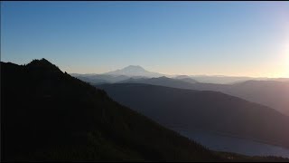
Tough Forest Road climb to the top, a bit of hike a bike and then spectacular single track for an hour or more - all downhill to the cars. Breathtaking scenery of the Central Cascades, including Lake Kachess, Mt. Rainier, Mt. Stuart, and more. The singletrack portion of the trail generally follows Silver Creek on a winding descent through shadowy glades, open meadows, sections of head-high wildflowers, and exposed ledges. This is a wilderness ride not for the faint of heart - several hours of endurance required, and richly rewarded.

Do not ride in the spring/early summer when the trail is wet from snow melt or snow covered (with the exception of the hike a bike to the saddle). This causes damage to the trail, particularly the meadows, especially now that the trail is getting a lot of use. Local rule of thumb: Don't ride until July 4th or later. However you can ride up the singletrack (reverse of what is described below) to avoid the snow and/or do recon in the late spring.

Reminder that this is a multi-use trail and you may encounter horses and/or hikers. With shuttle services and such happening up there this really needs to be taken into consideration. There are lots of blind corners and it's easy to startle someone, or worse.

In the winter there is typically some tree blowdown - watch the EMBA website for trail clearance work parties in the early season. You cross several creeks on the way down, and early season they can be flowing pretty good. Prepare to get your feet wet

The switchbacks near the end of the trail are quite loose. Take your time and try not to make them worse by skidding!

Ride up road 4818 for 6 miles of gravel logging road riding and look for road 4824 on the right. Here's where the climbing starts. From here to Kachess Ridge trail is about 5 miles of up (10+% grade). Increasingly-worthy views of Rainier and the lake make a fine excuse for stopping for a breather. In a mile keep to the main road. You will pass a gate on this road and a little over a mile from the gate stay right. There are a handful of less-traveled spurs on the ascent; keep to the main road. When you come to a plateau and a fork in the road, go right and then look to the left for the easy to miss trail. Sort of looks like a spur road to camping spot to trail kind of thing all in about 50 feet. There are a couple of these entrances, all of which shortly meet.

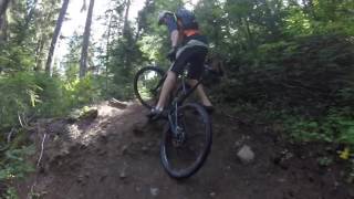
This trail descends immediately (lots of people walk this) to a T. Go right here. The object is to follow the trail to the pass between the pinnacles looming above. There's a bit of downhill, then some hike a bike across a scree slope and more hike a bike up to the pass. From here follow the trail down down down. Steeps, roots, rocks, rivers, streams, meadows, hairy switchbacks, and more. About half way down on the right there's the remains of a big avalanche a few years ago. Just before you get into the switchbacks (near the end) there are some nice waterfalls in Silver Creek you can climb down to. Then there are a few miles of steep somewhat eroded switchbacks returning you to the valley floor.

When you finally come to the bottom of the descent, take a quick right and ride through a short clearing which brings you to an access road. Ride this access road back to 4818 then take a left (south) about a mile back to the powerlines and your car. You've just completed the 18.5 mile loop!

Access Info

ake I-90 East until exit #70. Turn left and cross over the highway. Now take another left on Sparks Road (the frontage road). Follow this for 0.6 miles and turn right on Kachess Dam Road (also known as Forest Service Rd 481Cool . After 0.1 miles, the pavement turns to dirt park at the powerlines (about 1/3 mile).

Some will elect to shuttle by leaving one car at the power lines and driving one on 4818 and 4824 all the way to the top. Ground clearance is important for shuttle vehicles due to drainage ditches on 4824 - a loaded subaru wagon comes close to getting high centered.

Local Trail Association
Traditionally Indigenous Territory
More Stats for Kachess mountain bike trail trail
  • Altitude change
    -3,027 ft
  • Altitude min
    2,374 ft
  • Altitude max
    5,780 ft
  • Altitude start
    5,400 ft
  • Altitude end
    2,375 ft
  • Grade
    -6.5%
  • Grade max
    -85.1%
  • Grade min
    71.5%
  • Distance climb
    2 miles
  • Distance down
    7 miles
  • Distance flat
    2,008 ft
  • Avg time
    02:31:03
  • Avg reverse time
    00:03:03
  • view trail stats
Status:
on Oct 10, 2022
Dry
Avg: 4.15 (15 votes)
Your vote: 0

view (75)
close
3D
Trail Conditions
  • Unknown
  • Snow Groomed
  • Snow Packed
  • Snow Covered
  • Snow Cover Inadequate
  • Freeze/thaw Cycle
  • Icy
  • Prevalent Mud
  • Wet
  • Variable
  • Ideal
  • Dry
  • Very Dry
Trail Flow (Ridden Direction)
Trailforks scans users ridelogs to determine the most popular direction each trail is ridden. A good flowing trail network will have most trails flowing in a single direction according to their intension.
The colour categories are based on what percentage of riders are riding a trail in its intended direction.
  • > 96%
  • > 90%
  • > 80%
  • > 70%
  • > 50%
  • < 50%
  • bi-directional trail
  • no data
Trail Last Ridden
Trailforks scans ridelogs to determine the last time a trail was ridden.
  • < 2 days
  • < 1 week
  • < 2 weeks
  • < 1 month
  • < 6 months
  • > 6 months
Trail Ridden Direction
The intended direction a trail should be ridden.
  • Downhill Only
  • Downhill Primary
  • Both Directions
  • Uphill Primary
  • Uphill Only
  • One Direction
Contribute Details
Colors indicate trail is missing specified detail.
  • Description
  • Photos
  • Description & Photos
  • Videos
Trail Popularity ?
Trailforks scans ridelogs to determine which trails are ridden the most in the last 9 months. Trails are compared with nearby trails in the same city region with a possible 25 colour shades. Think of this as a heatmap, more rides = more kinetic energy = warmer colors.
  • most popular
  • popular
  • less popular
  • not popular
ATV/ORV/OHV Filter
Max Vehicle Width
inches

Radar Time
x Activity Recordings
Trailforks users anonymized public ridelogs from the past 6 months.
  • mountain biking recent
  • mountain biking (>6 month)
  • hiking (1 year)
  • moto (1 year)
Activity Recordings
Trailforks users anonymized public skilogs from the past 12 months.
  • Downhill Ski
  • Backcountry Ski
  • Nordic Ski
  • Snowmobile
Jump Magnitude Heatmap
Heatmap of where riders jump on trails. Zoom in to see individual jumps, click circles to view jump details.
Trails Deemphasized
Trails are shown in grey.
disable
Only show trails with NO bikes.
enable

Save the current map location and zoom level as your default home location whenever this page is loaded.

Save
      Directions to kachess trailhead (47.367860, -121.207120)
      update trails status or condition

      Kachess Trail Reports

      statusdatedescription
      Oct 10, 2022 @ 12:05pm
      Oct 10, 2022
      Still dry at start when shutting. Good dirt in the woods. MKe sure you pick good lines in the chunky parts!!!
      Sep 26, 2022 @ 7:11am
      Sep 26, 2022
      Rode from the shuttle drop-off. Dry and loose in the sun, good dirt in the shade, which is most of it. Good fall colors on the ground up the top....
      Sep 2, 2022 @ 8:47pm
      Sep 2, 2022
      A week of dry weather and no more hero dirt : ( Rode the six miles down from the shuttle drop off. The trail above that is signed closed by...
      Aug 24, 2022 @ 7:53pm
      Aug 24, 2022
      got some rain yesterday - hero dirt. Running beautifully.
      Jul 24, 2022 @ 8:02am
      Jul 24, 2022
      Big thank you to Cascade Crest 100 Ultra for clearing the trail! It’s running well, but don’t get there via No Name Ridge. Bad idea, unless...
      view all reports »

      Recent Ridelog Activity on Trail

      Past Week
      • 0 rides
      •  
      6 Months
      • 0 rides
      •  
      All
      • 69 rides
      • Last: Sep 14, 2022

      Photos

      more »
      6 |
      Oct 16, 2022 @ 9:46am
      Oct 16, 2022
      2 |
      Oct 16, 2022 @ 9:46am
      Oct 16, 2022
      182 |
      Aug 10, 2021 @ 10:49pm
      Aug 10, 2021
      144 |
      Aug 10, 2021 @ 10:49pm
      Aug 10, 2021

      Routes with this trail

      more »
      titledistance
      Kachess Ridge13 miles
      Kachess Ridge Runner13 miles
      Kachees Ridge Loop18 miles
      Freehub Magazine: Kachess8 miles

      Links

      9 Reviews & Comments


      We hope you've been enjoying Trailforks!

      Create a FREE account to view trail comments and much more.

      Videos

      more »
      youtuber VOTR Kachess
      5:08 | 1313 | Oct 19, 2018 , My City
      Kachess Ridge Trail
      1407 | Sep 22, 2016 , My City
      Kachess Ridge Helmet Cam
      5:48 | 515 | Mar 22, 2010 , My City
      Lower Kachess Ridge
      1:45 | 985 | Jan 24, 2014 , My City
      • subscribe
      • flag
      • login to download gpx or kml files.