
![This Green Trail is 7km Long! Lazy Lizard [Fernie]](https://ev1.pinkbike.org/tf/vt/1/yvt-183741-4.jpg)


Open in App
Get this trail on your phone instantly.

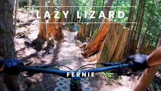
This is one of the most beautiful trails in Fernie - machine built, loads of bridges, meandering through an Old Growth Cedar Forest. It's probably one of the most beautiful trails in the world. A few scenic look out points and if you go all the way you kick out at world-famous Island Lake Lodge and can sit on their deck and have an amazing meal with astonishing views of the Three Bears and Island Lake. There are not many places you can go for a wilderness bike and end up somewhere like that. Once you've finished your lunch you get the most amazing flowy ride downhill you will probably ever have - loads of gentle berms of rolls to enjoy. Just be aware that this trail gets a lot of people on it, and it is not a good idea to see if you can get the Strava DH KOM on a weekend afternoon. You will probably kill someone.
Drive into the Mount Fernie Provincial Park access road and then follow the signs to Island Lake Lodge. When you get to the big wooden structure over the road signalling the entrance to island Lake terrain, park in the big lot to the left of the structure. Alternatively, you can make it a longer ride and start in the Mt Fernie Provincial Park on the Lazy Lizard Connector
Make sure to check Island Lake’s Operations Calendar for the latest updates on road access and lodge hours. Note that shuttling the access road from the parking lot to the lodge is not permitted.
| c1 | c2 | c3 | c4 |
|---|---|---|---|
January | February | March | April |
May | June | July | August |
September | October | November | December |

Service Road Atlas is a free to use, community-driven service for viewing and creating reports on the numerous back-country service roads around B.C. and Alberta.
Save the current map location and zoom level as your default home location whenever this page is loaded.
SaveWe hope you've been enjoying Trailforks!
Create a FREE account to view trail comments and much more.
You must enter a description before submitting.

