more stats
2,533 ft
Distance
-490 ft
Descent
00:09:15
Avg time
-490 ft
Altitude change
1,249 ft
Altitude min
1,740 ft
Altitude max
1,740 ft
Altitude start
1,250 ft
Altitude end
-19.4%
Grade
-47.1%
Grade max
-2%
Grade min
2,513 ft
Distance down
20 ft
Distance flat
00:09:15
Avg time

LB-Cycle Details

  • Activities
    • Mountain Bike
    • E-Bike
  • Riding Area
    Sentiers du Moulin
    Lac Beauport, Quebec
  • AKA
    LB1, LBC1
  • Difficulty Rating
  • Voted Difficulty
    Black Diamond (2 votes)
  • Local Popularity
    40 in Mountain Biking [+]
    • 40 in E-Biking
  • Global Ranking
    #3418 in Mountain Biking [+]
    • #7456 in E-Biking
  • Trail Type
    Singletrack
  • Bike Type
    DH, AM
  • Direction
    Downhill Only[+]
    Popular Direction Shown
    • Downhill Only for E-Biking
  • Climb Difficulty
    Blue
  • Physical Rating
    Moderate
  • Trail Visibility
    Always easy to follow
  • Season
    Mai à octobre
  • eBike Allowed
    Yes up to Class 1
  • TTFs on Trail
    Berm, Bridge, Drop, Jump, Rock Face, Rock Garden
  • Year Opened
    2015
  • Land Owner

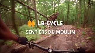
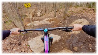
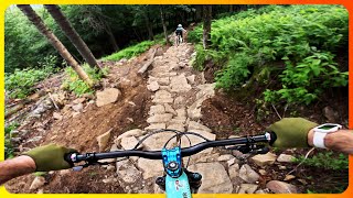
Aménagée en 2015 par le groupe LB-Cycle en collaboration avec Patrice Dorion pour le volet mécanisé, cette descente d’environ 1 km, réservée aux experts, relie le sommet de la montagne à l’ancien camping près de l’accueil. Née de près de 400 heures de bénévolat, elle s’est rapidement imposée comme une ligne engagée et unique au Québec.

À l’été 2025, dix ans après son ouverture, la LB-Cycle a été entièrement réaménagée par les bénévoles de LB-Cycle. Des centaines d’heures de travail ont permis d’y ajouter de nouvelles sections sur dalle et enrochements, d’améliorer le flow, d’intégrer quelques sauts, une nouvelle ligne, un nouveau viaduc et plusieurs interventions visant à améliorer la durabilité du sentier. Ce réaménagement lui donne aujourd’hui une tendance légèrement plus freeride. Le projet a été mené par Alex Beaulieu et Guy-Charles Valois.

-----------------------------------------------------------

Built in 2015 by the LB-Cycle group in collaboration with Patrice Dorion for the machine-built work, this approximately 1 km descent, reserved for expert riders, connects the summit of the mountain to the former campground near the main lodge. Born from nearly 400 volunteer hours, it quickly established itself as a unique and committing line in Quebec.

In the summer of 2025, ten years after it first opened, LB-Cycle was completely rebuilt by LB-Cycle volunteers. Hundreds of hours of work went into adding new rock slab and rock-armored sections, improving the flow, integrating a few jumps, a new line, a new bridge, and several other interventions aimed at improving the trail’s long-term durability. This rebuild gives the trail a slightly more freeride-oriented character today. The project was led by Alex Beaulieu and Guy-Charles Valois.

Disclaimer

Ce sentier s'adresse aux cyclistes expert seulement !!!

Local Trail Association
Traditionally Indigenous Territory

Recent Activity on Trail

Past Week
  • 0 rides
  •  
6 Months
  • 1 rides
  • 3 miles avg distance
All
  • 370 rides
  • Last: Jun 6, 2026
c1c2c3c4
January
February
March
April
May
June
July
August
September
October
November
December
update trails status or condition

LB-Cycle Trail Reports

Status:
on May 4, 2026
Prevalent Mud
Avg: 4.68 (25 votes)
Your vote: 0

view (3,329)
close
3D
Trail Conditions
  • Unknown
  • Snow Groomed
  • Snow Packed
  • Snow Covered
  • Snow Cover Partial
  • Freeze/thaw Cycle
  • Icy
  • Prevalent Mud
  • Wet
  • Variable
  • Ideal
  • Dry
  • Very Dry
Trail Flow (Ridden Direction)
Trailforks scans users ridelogs to determine the most popular direction each trail is ridden. A good flowing trail network will have most trails flowing in a single direction according to their intension.
The colour categories are based on what percentage of riders are riding a trail in its intended direction.
  • > 96%
  • > 90%
  • > 80%
  • > 70%
  • > 50%
  • < 50%
  • bi-directional trail
  • no data
Trail Last Ridden
Trailforks scans ridelogs to determine the last time a trail was ridden.
  • < 2 days
  • < 1 week
  • < 2 weeks
  • < 1 month
  • < 6 months
  • > 6 months
Trail Ridden Direction
The intended direction a trail should be ridden.
  • Downhill Only
  • Downhill Primary
  • Both Directions
  • Uphill Primary
  • Uphill Only
  • One Direction
Contribute Details
Colors indicate trail is missing specified detail.
  • Description
  • Photos
  • Description & Photos
  • Videos
Trail Popularity ?
Trailforks scans ridelogs to determine which trails are ridden the most in the last 9 months. Trails are compared with nearby trails in the same city region with a possible 25 colour shades. Think of this as a heatmap, more rides = more kinetic energy = warmer colors.
  • most popular
  • popular
  • less popular
  • not popular
ATV/ORV/OHV Filter
Max Vehicle Width
inches
US Cell Coverage
Legend
cell carrier legend

Radar Time
Activity Recordings
Trailforks uses anonymized public activity data. ?
Activity Recordings
Trailforks uses anonymized public activity data. ?
Personal Heatmap
Activity Types
all / none
Options
2
Date range month
Winter Trails
Warning A routing network for winter maps does not exist. Selecting trails using the winter trails layer has been disabled.
Missing Trails
Most Popular
Least Popular
Trails are colored based on popularity. The more popular a trail is, the more red. Less popular trails trend towards green.
Jump Magnitude Heatmap
Heatmap of where riders jump on trails. Zoom in to see individual jumps, click circles to view jump details.
BC Backroad Status

Service Road Atlas is a free to use, community-driven service for viewing and creating reports on the numerous back-country service roads around B.C. and Alberta.

map legend
Slope Aspect
Direction the slope faces
Flat N NE E SE S SW W NW
Trails Deemphasized
Trails are shown in grey.
disable
Only show trails with no bike usage.
Enable
Suggested Layers
Based on selected activity type

    Save the current map location and zoom level as your default home location whenever this page is loaded.

    Save
        Directions to lbcycle trailhead (46.991640, -71.268410)

        Photos

        28 more »
        397 |
        Aug 24, 2017 @ 4:19am
        Aug 24, 2017
        29 |
        Mar 29, 2026 @ 8:49am
        Mar 29, 2026
        27 |
        Mar 29, 2026 @ 8:49am
        Mar 29, 2026
        20 |
        Mar 29, 2026 @ 8:49am
        Mar 29, 2026

        Videos

        14 more »
        youtuber POV | LB-Cycle | Sentiers du Moulin
        3:11 | 1414 | Sep 25, 2017 , Lac Beauport
        LB-Cycle - Sentiers du Moulin
        3:59 | 127 | Sep 23, 2024 , Lac Beauport
        youtuber Double Préouverture des réseaux à Québec!
        16:21 | 154 | May 7, 2024 , Lac Beauport
        youtuber Helping My Wife Tackle a Double Black She's...
        11:17 | 267 | Jan 2, 2024 , Lac Beauport

        Routes with this trail

        5.0 11 miles 2,231 ft 14 Loop
        Enchaînement idéal pour les riders plus expérimentés et amateur de descente. L'idée est d'enchaîner...
        5.0 12 miles 2,483 ft 51 Loop
        Enchaînement des 4 descentes du sommet : la « Léon », la « Super G », la « LB Cycle » et la « »....
        2.8 12 miles 2,492 ft 60 Loop
        A route to ride the 4 SDM's beautiful enduro trails ( , Léon, LB-Cycle and LBC2)

        2 Reviews & Comments


        We hope you've been enjoying Trailforks!

        Create a FREE account to view trail comments and much more.

        • By SentiersduMoulinTF Pro VQ SDM & contributors
        • #37747 - 7,945 views

        Frequently Asked Questions About LB-Cycle

        Where is LB-Cycle located?
        LB-Cycle is located in Sentiers du Moulin, Lac Beauport, Quebec, Canada. It is part of the Sentiers du Moulin trail network. The trailhead is located at coordinates 46.99164, -71.26841.
        How hard is LB-Cycle?
        LB-Cycle is rated as Double Black Diamond difficulty. The physical rating is Moderate. The average grade is 19.4%. The climb difficulty is rated Blue.
        What is the elevation gain for LB-Cycle?
        The trail has 490 ft of elevation descent. The elevation ranges from 1,249 ft to 1,740 ft.
        How long is LB-Cycle?
        LB-Cycle is 2,533 ft long. The trail type is singletrack.

        Hit the Trail

        Open in App

        Get this trail on your phone instantly.
        open trail in app

        Download Trail

        Save to wishlist, Garmin & download.
        save the trail

        Find Related Routes

        Find routes and users activities that include this trail.
        find routes for this trail

        You must enter a description before submitting.