Lone Cactus Loop Details
-
Activities
- Mountain Bike
- E-Bike
-
Riding AreaFantasy Island
Tucson, Arizona -
Difficulty Rating
-
Trail TypeSingletrack
-
Bike TypeXC
-
Trail UsageBiking Primary
-
DirectionOne Direction
-
Climb DifficultyBlue
-
Physical RatingModerate
-
SeasonAll Year
-
Dogs AllowedYes
-
eBike Allowed
-
Ride in RainYes
-
Global Ranking#30865 in Mountain Biking
-
Local Popularity100 in Mountain Biking [+]
- 90 in E-Biking
-
Land ManagerArizona State Trust Land
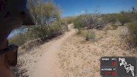
The Cactus Loop is around 6 Miles long, consisting of winding and rolling hills, singletrack. I would categorize the skill level of this trail at a low intermediate for difficulty. Mostly due to ruts from the rain, rocky descents and climbs, and the Cacti. Many beginners start here but they are instantly challenged. The Cactus Loop can connect to the Bunny Trail, Christmas Tree and the Burro Loop. Right turns will take you to one or the other named trails or stay left to continue on the Cactus Loop. There are a few tricky sections to be aware of, especially during monsoon season (July-September). Watch the wash crossings, dips and "The Shaft" as they can be steep, rutted or washed out.
Access Info
Trail is 40 yards south of the intersection at Irvington and Harrison Rd. Park in the lot or dirt and jump on the Paved Bike Path. You will see a picnic table on the left and the trail is just to the right of that area and a sign. The Cactus Loop ends just behind the picnic table.
Local Trail Association
-
Please consider joining or donating to the local trail association to supportdonate to earn trail karma!
trail development & maintenance.
More Stats for Lone Cactus Loop mountain bike trail trail
-
Altitude change2 ft
-
Altitude min2,793 ft
-
Altitude max2,857 ft
-
Altitude start2,822 ft
-
Altitude end2,825 ft
-
Grade max-11.9%
-
Grade min8.7%
-
Distance climb2 miles
-
Distance down2 miles
-
Distance flat2 miles
-
Avg time00:35:32
-
Avg reverse time00:57:58
- view trail stats
- Unknown
- Snow Groomed
- Snow Packed
- Snow Covered
- Freeze/thaw Cycle
- Icy
- Prevalent Mud
- Wet
- Variable
- Ideal
- Dry
- Very Dry
The colour categories are based on what percentage of riders are riding a trail in its intended direction.
- > 96%
- > 90%
- > 80%
- > 70%
- > 50%
- < 50%
- < 2 days
- < 1 week
- < 2 weeks
- < 1 month
- < 6 months
- > 6 months
- Downhill Only
- Downhill Primary
- Both Directions
- Uphill Primary
- Uphill Only
- One Direction
- Description
- Photos
- Description & Photos
- Videos
- most popular
- popular
- less popular
- not popular
- Access Road/Trail
- White
- Green
- Blue
- Black
- Double Black Diamond
Trail Report Status
- Clear / Green
- Minor Issue / Yellow
- Significant Issue / Amber
- Closed
- Land Owner Overlay
- Wilderness (typically no bikes in USA)
- BLM (public)
- USFS (Wildlife sanctuaries darker than usfs)
- State land
- Indigenous
- Military
- Unknown
- Snow Groomed
- Snow Packed
- Snow Covered
- Freeze/thaw Cycle
- Icy
- Prevalent Mud
- Wet
- Variable
- Ideal
- Dry
- Very Dry
- Map Markers
Trail Head
Photo
Directory Listing
Riding Area
TTF
Parking
Viewpoint
Information
Warning
Directions
Sight
Restrooms
eBike Charging Point
Water Fountain/Source
Gate
Trail Sign
Table or Bench
Ladder
Stairs
Bridge
Boardwalk
Camping
Cabin
Lodge
Bear Cache
Dock
Ranger Station
Summit
Other
Lone Cactus Loop Trail Reports
Recent Ridelog Activity on Trail
Past Week
- 27 rides
- 9 miles avg distance
6 Months
- 615 rides
- 12 miles avg distance
All
- 2,974 rides
Photos
Trail Events


Videos
Nearby Trails
- Bos Loop 1 mile
- Connector 1 mile
- Connector 1 mile
- Lone Cactus Loop (connect) 1 mile
- Burro Pit Loop 1 mile
- embed Lone Cactus Loop trail on your website
- By todd
Trailforks Plus & contributors
- #15401 - 3,385 views
- subscribe
- login to download gpx or kml files.
All-mountain, carbon rentals available as well as guiding & shuttle services on Mt Lemmon and on the Arizona Trail.